Top
 

Ruby Valley

A hidden gem in more ways than one!

Ruby Valley

$915 per person

Ruby Valley

A hidden gem in more ways than one!

Ruby Valley Trek

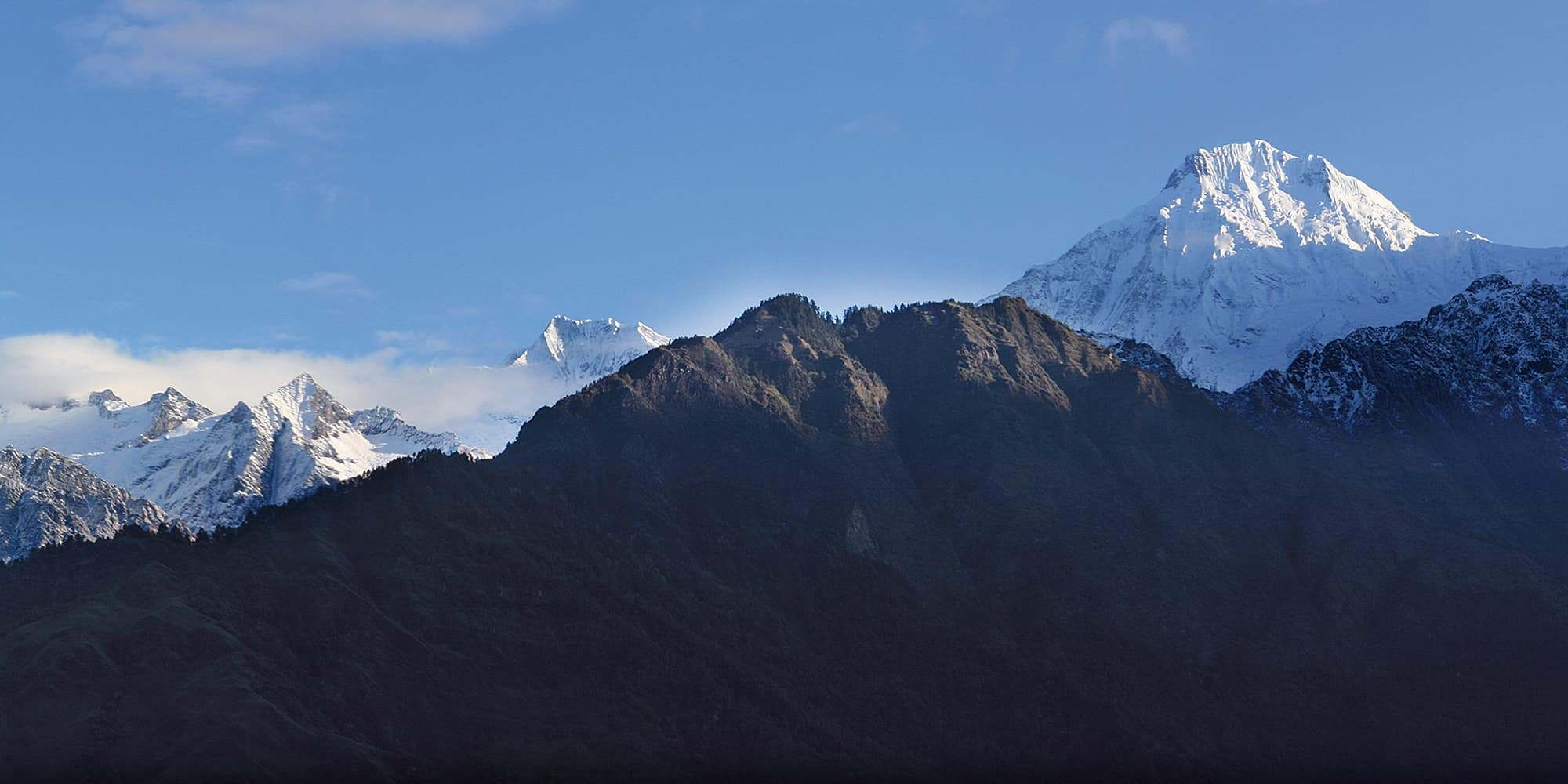
The Ruby Valley is a true gem of a trek in more ways than one! Some terrific views combine with authentic mountain hospitality to form one of the best low-altitude treks in Nepal. Add some intriguing history about a deserted gem mine and it’s time to go!

Is this tour for me?

Travel Style: Active with Guide in Teahouses

Hiking, trekking, adventure with a guide, and staying in teahouses.

Physical Rating: 3 - Energetic

Trail is sometimes on a rough track with obstacles and arduous sections with limited signage.

Service Level: Basic Teahouse

Comfy, family-owned teahouses with all meals provided along the trail.

Check Your Visa Requirements

Before booking, use our handy entry requirements tool so you know which documents you need to enter and travel through the countries on your trip.

Recommended Group Size

Small group experience; Max 12, Avg 2 to 8

Age requirement: 12+

All travellers under age 18 must be accompanied by an adult.

When to Trek Ruby Valley?

The Ruby Valley is one of the few year-round trails, but is at its best from mid-October to May. You should be careful of heavy snowfall during winter storms, especially in January and February, which can close passes for weeks at a time. However, the other, lower trails are all open over winter and offer some fantastic off-season trekking! General delays can occur in all seasons, so you should make sure you can adjust your itinerary if necessary.

Ruby Valley
From 8-10 days

Ruby Valley

Difficulty

days

Postive Impacts

GHG Footprint of 15kg CO2e per day

Social Impacts: 60% of trek expenses support local communities directly

Why you will love this Trek

Trekking Grade: Grade 3 Energetic Stunning mountain views Super friendly villages Beautiful forests Enchanting cultures Comfy teahouses
Tamang Heritage Trail Gatlang
Ruby Valley Ganesh Himal

Ruby Valley: Route Options

From Timure (the village before Rasuwa, to the north of Syabrubesi) there is a small trail to Dudh Kund on the northern slopes of Langtang Lirung. WH Tilman was the first European to trek in Nepal in 1949. This was the first place he tried to reach, but he couldn’t find it as the trails were bad; they’re not much better today!

Manaslu and Ganesh region map
Langtang Valley Map

How can your Ruby Valley Trek create positive impacts?

To help you budget and plan, we’ve made a comprehensive costing explanation on How Much Does the GHT Cost? But here’s a simplified breakdown.

Estimated Cost US$2,225

Trek cost per person (twin share)

Total GHGe per trekker

58kgCO2e

Total GHGe per trekker per day

6kgCO2e

Average per capita EU GHGe = 20kgCO2e per day (www.statistica.com)

Go Local equals positive impacts

What we do…

…make Positive Impacts

% of Trek Cost

Go Local Transport

Use Local Accommodation

Eat Local Meals

Waste Management

Highly Experienced Guide

Biodiversity

Locally supplied transport reduces drive times and fuel usage

Locally supplied accommodation reduces commissions

More nutritious, fresher ingredients, no packaging

Carry out ALL PLASTIC, avoid snacks and soda drinks

A knowledge bank for your peace and wellbeing

National Park entry fee for you and the team

Administrative and office costs

22%

38%


0%

20%

15.2%

4.8%

Do you have any questions about the trail, when to go or the costs? Please Get in Touch to ask an expert and for more details.

Bookings

Please note that www.greathimalayatrail.com does not handle bookings for treks. We are here to inform you about the trails and logistics, but you will need to book through a registered Local Operator LINK in Nepal. Get in Touch

Customisation is Normal

Want to do things a little differently? Maybe take some extra time, or go a bit faster? Or avoid the technical sections? Every GHT is different and that changes the impact and the price, but this it totally normal and your Local Operator will be able to adjust plans without problems. Get in Touch

Social and Environmental Impacts

The GHT has been designed around the principles of Responsible Sustainable Tourism and we do our very best to make sure that the GHT is good news for the locals and the environment along the trails. To walk the talk, we have pioneered the development of social impact assessment and Greenhouse Gas emissions, and environmental impacts like waste created for each trek. There is more information about how we calculate impacts at Impact of Your GHT Get in Touch

Itinerary

DAY 1: KATHMANDU – MACHHAKHOLA

After an early start, you should reach Machhakhola after lunchtime and have time to relax in the afternoon with views of the Budhi Gandaki river.

DAY 2: MACHHAKHOLA – JAGAT 6.5 HRS

We follow the dirt road north out of the village and soon reach Khorlabesi (970m, 1 hour) and then on to Tatopani (990m, 1 hour) where the waterspouts make a good washing stop. At the end of the village, cross a suspension bridge to the true left (east) bank and continue through sometimes dense forest to Dobhan (1070m, 1.5 hours), where there are teahouses.

Continue on a broad trail on the true left bank of the river to Yaruphant (1170m, 1 hour), where there are a few teashops on a broad grassy slope. From here, the trail climbs about 200m up what was once an enormous landslide that blocked the Budhi Gandaki. The trail descends a little from the top of the climb to the broad riverbed. In the trekking seasons, there are some temporary teashops (1.5 hours from Yaruphant) at the confluence of the Yara Khola.

Vertical cliffs rise on both sides of the valley as a spectacular trail continues on the true left (eastern) bank for 15 minutes to a bridge, which you cross to the true right bank and where the Budhi Gandaki has cut a narrow gorge. After a short climb and descent of 20 minutes, you reach a flat area where there is a teashop and two grassy campsites signposted ‘Jagat’. The village is 10 minutes further up the trail, behind a rocky spur. As you enter Jagat (1340m) on a good stone-paved trail, there is a community-owned campsite on your left and some teahouses before the Manaslu Conservation Area Project (MCAP) and police checkpost. Jagat is a common village name in the high mountains as it means ‘customs post’ and is the traditional tax collection point for trade to and from Tibet. 

DAY 3: JAGAT – DENG 6 HRS

Beyond the village is the Pangaur Khola, which is crossed using stepping stones and log bridges. The trail now climbs an easy gradient to a chautara (1 hour), where there are good views of Shringi Himal to the north. Descend to Sirdibas (1420m, 40 mins) and turn a sharp left turn at the end of the village to ascend a stream for about 50m before turning sharp right for the main trail. Continue to a suspension bridge, which you cross to the true left bank of the Budhi Gandaki (there is a police checkpost at the bridge), and then climb 200m to the village of Phillim (1570m, 40 minutes), another MCAP checkpost and teahouses.

This next section of trail is spectacular and well worth the effort of a long day’s walk. Ekla Bhatti (1650m) is about 45 minutes from Phillim, but take your time and admire the waterfalls on the west side of the valley. After the monsoon, there is a large waterfall beyond Ekla Bhatti, after which you enter a scrubby forest that gives way to large pine trees. Forty minutes from Ekla Bhatti you reach a trail junction, where you turn left (the right-hand trail goes to Tsum, see pp000-00). Descend (5 minutes) to and cross a bridge, where the trail begins a gradual climb as the valley turns westwards. After the initial climb away from the bridge there is a small trail junction where you turn right (the left trail climbs steeply to Nyak).
Another bridge across the Budhi Gandaki is reached in 45 minutes, which you cross to the true left (north) bank to avoid a steep cliff. In another 15 minutes, you cross back to the true right (south) bank using a suspension bridge. In 20 minutes, you will reach Pewa and the junction with the high trail from Nyak (this is where you join the Circuit trail from Rupina La). It’s a good campsite and teahouses at Deng (1860m), which is now 30 minutes away along a pleasant trail with good views of the narrow gorge cut by the Budhi Gandaki.

DAY 4: DENG – NAMRUNG 5 HRS

As the Manaslu Circuit trail turns westwards, the shape of the homes changes to squat, dry-stone structures to reflect the changing demands of climate and the architectural influences of Tibet. Mani walls, chorten, and kani are common along the trail. Rice and wheat are replaced by buckwheat, barley, and maize in the fields. The trail descends to a suspension bridge, which you cross to the true left (north) bank of the Budhi Gandaki and then climbs roughly 100m to Rana (1910m, 35 minutes).

The trail now climbs an easy gradient beneath the village of Umbaie (above which is Shringi Gompa) before winding through the Shringi Khola gorge to Bhi (1990m, 45 minutes). Follow an undulating trail through sparse pine trees and hamlets to a large kani (1½ hours) that marks the entry to the Prok and Ghap communities. The paintings and mani stones on this kani are in good condition. The fierce blue and red characters on the kani ceiling and walls are protectors who are meant to stop evil spirits from entering the villages beyond. There is a teahouse and campsite at Prok, only 10 minutes further on.

The trail now gradually swings back to the river, which you cross to the true right bank via a suspension bridge. It’s a slight climb to Ghap, where there are a couple of teashops. The valley narrows and you pass through fine broad-leaf forest to a spectacular canyon carved by the river (45 minutes), which you re-cross in another 15 minutes on a larger bridge.
Note: the Himal Chuli Base Camp trail veers left here and climbs the Sherang Khola valley.
From the second bridge, the trail climbs more steeply for almost an hour to Namrung (2630m), where there is a campsite and teahouses.

DAY 5: NAMRUNG – SAMA (RYO) 5.5 HRS

Leave Namrung by crossing Therang Khola along an easy trail that passes a waterfall on your left before entering the scattered village of Barchham (20 minutes). The trail now climbs a bit less than 300m on an easy gradient to Lihi (2920m, 50 minutes), where there is a campsite and teahouses. Descend and cross the Hinan Khola on the far side of the village and ascend an easy trail to Sho (2880m, 45 minutes). It is now an easy uphill gradient to Lho (3180m, 1 hour), where there is a campsite and teahouses, but take your time and enjoy the evolving mountain panorama around you.
Manaslu dominates the skyline at Lho and if you have the time explore the village’s mani walls, kani, and Ribang Gompa, which sits on a hill above the village. The trail descends to the Thusang Khola and then climbs a steady gradient for 300m to Shyala (80 minutes), a community of mainly log cabins where there is another campsite and teahouses. Next, the trail dips through the Numla Khola before descending slightly and then becoming flat to Sama (Ryo; 3520m, 70 minutes), where there are teahouses and campsites to choose from at the far end of the village.

DAY 6: SAMA (RYO) ALL DAY

It is a good idea to spend a day in Sama (Ryo) exploring the village and/or some of the surrounding viewpoints as part of an acclimatisation programme. One of the most popular places to visit is the Pung Gyen Gumba beneath the east face of Manaslu. To get there, backtrack on the Shyala trail to a junction before the Numla Khola, where you turn right and begin a long and sometimes steep climb for 2 hours and 20 minutes. Once you have crested the ridge above the river the gradient eases and ahead you will see the small gompa. You will be expected to provide a donation to the gompa if you visit it. Higher still is a cave gompa and hot springs, but relaxing in the grassy kharka near the gompa and enjoying the view of Manaslu is a popular pastime before returning to Sama in 1½ hours. Alternatively, explore the village and gompas of Sama, or take a local guide to Birendra Kund for reflections of Manaslu and its northern icefall. 

DAY 7: SAMA (RYO) – SAMDO 2.5 HRS

An easy day to Samdo can be combined with a side trip to Birendra Kund. Leave Sama on a broad trail that runs north from the village across grassy kharkas. Remain on the western side of the valley, following a trail that runs parallel to the Budhi Gandaki. After 45 minutes cross the outflow from Birendra Kund to the summer herding area of Kermo Kharka where there is an excellent view of Manaslu from the impressive mani wall.
The trail continues to climb an easy gradient for an hour before dropping to a bridge over the river. Climb to an impressive kani, which marks the entry to Samdo (3875m, 30 minutes). This is a Tibetan refugee settlement of about 40 homes, created after the Chinese occupation of Tibet. The border runs along the top of the hills above Samdo and makes an ideal side trip.

DAY 8: SAMDO – LARKYE LA DHARAMSALA 3 HRS

From Samdo the trail descends to a bridge across the Gyala Khola. Climb the trail on the far side to a large pile of mani stones (40 minutes), where you can look down on Larkye Bazaar, a trading ground (there are no buildings as such) where Tibetans sell large herds of goats before the Nepali festival of Dashain in October/November. The trail now climbs an easy gradient with views of Larkye Peak and the north face of Manaslu for 2 hours and 20 minutes to Larkye La Dharamsala (4460m), where there is a teahouse. Take some time to check that you are well prepared to cross the pass tomorrow.

DAY 9: LARKYE LA DHARAMSALA – LARKYE LA – BIMTANG 7 HRS

The longest and toughest section of the Manaslu Circuit now awaits, but also the most magnificent views – Himalayan majesty and grandeur all around. It is wise to start before sunrise and climb an ablation valley to view of Cho Danda. Although there are some prayer flags at the top of the Ablation Valley (4690m, 80 minutes) you are not at the top of the pass. The trail now crosses rough undulating moraines for 30 minutes to another dharamsala (4905m). From here the trail begins to climb more steeply to the top of Larkye La (5135m, 1¾ hours), where you will be greeted by magnificent views of the upper Bimtang valley and a roofless dharamsala. Views of Himlung and Cheo Himals, Gyagi Kang, Menjung, Kang Guru, and Annapurna II fill the horizon. Descend from the pass down a steep slope, which is often snow-covered and icy (and may require a handline), for 1½ hours. Beneath you are three glaciers spotted with numerous turquoise lakes; head for the ablation valley to the left of all the glaciers. An easy gradient then leads down to the campsite at Bimtang (3590m, 2 hours), which is serviced by four competing teashops staffed by pretty Gurung women.

DAY 10: BIMTANG – KHARCHE 5.5 HRS

Continue to follow the ablation valley south from Bimtang, which soon gives way to lateral moraine after 10 minutes. There are good views of the west face of Manaslu from here. Cross a branch of the glacial melt and then turn left, over some more moraine before crossing the main stream of glacial melt and then climbing a ridge of lateral moraine topped by some prayer flags (20 minutes).
The trail descends a little steeply through pine and rhododendron forest for 15 minutes before levelling to a gentle downhill gradient. As you descend towards the Dudh Khola through forest the trail passes through a few kharka. There is a lone teashop at Yak Kharka (aka Sangure Kharka, 3020m, 80 minutes) after a copse of mountain pepper trees. From here the trail can be a little difficult to follow across some large landslides and through scrubby forest to the scattered settlement of Kharche (1 hour).

DAY 11: KARCHE – DHARAPANI 4 HRS

The trail now climbs an imposing ridge that juts into the centre of the valley before a long descent to the many fields of Goa (2515m, 1.5 hours), where there are two teahouses. It is now a gentle downhill to the large Gurung village of Tilije (2300m, 50 minutes), where you cross a bridge pass a new school, and begin road-trekking again. After 20 minutes you come to a trail junction; turn right and descend to Thonje (1965m, 50 minutes), which you reach after crossing a long suspension bridge. Once at the village continue on the road to a T-junction in front of a teahouse. Turn left onto a dirt track and pass the school; after a short descent, cross a suspension bridge over the Marsyangdi river to Dharapani (1965m, 10 minutes), where there is a police checkpost and many comfortable teahouses. 

DAY 12: DHARAPANI – BESISAHAR – POKHARA/KATHMANDU

A road has been built from Besisahar to Manang, so you can take a jeep service from Dharapani and then you can transfer to a bus in Besisahar for services to Pokhara or Kathmandu. 

Trip Information

20-35 days

20-35 days

Tea – House Trekking with a Guide

Trekking with a Camping Crew

Make Sure You Include in Your Budget

Transportation

Private or Public Bus/Jeep,
plus walking conditions.

Accommodations

ask for GHT Check-In Point Teahouse
Lodges (6 nights).

Safety & Wellbeing

Does your guide have Wilderness First
Aid training?

Other things to consider:

  • Special care airport pickup
  • English or your preferred language speaking local guide for the trek and city tours
  • All necessary permits for trekking
  • Local porters could be included on the trek
  • All transport between destinations and to/from included activities

Choose Your Local Operator

  • Destination
  • Departure
    Kathmandu
  • Dress Code
    Low-altitude alpine clothing and camping equipment required
  • Included
    Ruby Valley
  • Grade
    Grade 3
  • Idea Date Range
    15/10/2021
  • Style of Trek
    Teahouse or camping
1
Day 1: Kathmandu–Syabru Besi 8hrs drive
The drive from Kathmandu offers good views of Manaslu, Ganesh and Langtang Himals as well as brief glimpses of village life in the Himalaya. The first section is a sealed road to Trisuli before the precipitous dirt road to Dhunche, where there is a National Park and police checkpost. Continue to Syabrubesi (1503m), where there are many teahouses and a campsite. As most of the day’s drive is on dirt roads, a light scarf to protect your face against dust may be useful.   Ruby Valley Locals in Somdang love to tell the story of why the road exists. They say that the Nepal Army built the road to supply a security post at Somdang. The post was established to protect a nearby mine, which many believe mined precious gem stones including rubies. Others say it was a lead mine and the ensuing debate is always fun to watch! However, there is some truth to the story. A seam of zinc and lead ore that runs through the Ganesh Himal (between 4000 and 5000m) was identified in 1981. A disused research mining facility sits beneath Paldor Peak at the head of the Somdang valley. The ore has traces of silver and some garnets and there are many stories of locals finding good-quality rubies in secret locations throughout the region. It is said that some of the jewels worn by the kings of Nepal came from here.
2
Day 2: Syabru Besi–Gatlang 5¾hrs
There are two trails to Gatlang (2300m) from Syabrubesi: the first option follows the new valley road to the Chilime Khola valley into which you turn west (left) and follow a good trail to Thambuchet and then to Gatlang (see Tamang Heritage Trail, day 8, p000). The second, faster option from Syabrubesi is to climb a trail that begins beside Buddha Guest House. This is a direct route to the Rongga Bhanjyang (2187m, 2hrs) above Syabrubesi, and also sometimes coincides with the route of an old road to Somdang. From the pass it is an easy 2 hours and 20 minutes along the road to Gatlang (2238m).
3
Day 3: Gatlang–Somdang 6hrs
From Gatlang the road is rarely used by motor traffic as landslides and fallen trees often block it. Follow a large track from Gatlang school up to Parvati Kund (45 mins). From the lake the trail intermittently cuts across the road as it winds through pine and rhododendron forest. At 3100m (1¾hrs) you come to a large kharka where you can camp. Not far above you re-join the road and follow it as it traverses a steep rocky hillside to another, smaller, kharka where the road does a U-turn. Here you take a small trail that climbs up and right, away from the road, into a gully filled with rhododendron to the Khurpu Dada Pass (3710m, 2hrs; Finaid: Somdan, sheet: 2885 13, ref: 194 171). For location reference, note a line of old powerlines (now only poles) that crosses the Khurpu Dada, small chautara and trail junction. To the north, along the ridge, is a small trail, which leads to Jaisuli Kund (Jageshwar Kund on the Finaid map, 3hrs), from where you could head to Paldor Peak Base Camp. Instead, head west and descend quickly, cutting across the road a few times, before following it again as it gradually descends to Somdang (3258m, 1½hrs), where there are some campsites and teashops.
4
Day 4: Somdang–Tipling 6¾hrs
From Somdang, the trail climbs up through forest and occasionally follows road construction, which is expected to reach Tipling and be finished in early 2020. In 2¾ hours you should reach a small pass at 3780m, where the trail begins traversing steep, rocky hillside. If there has been recent snowfall care should be taken to avoid small avalanches along this section of track. The trail traverses above a large kharka before arriving at the Pansan Pass (3830m, 1hr; Finaid: Somdan, sheet: 2885 13, ref: 153 165) where locals have built a small gompa and a small teahouse. Descend through rhododendron forest for 1¾ hours, passing through a couple of kharkas, which are potential campsites. However, it is best to continue to the terraced fields of Lawadun or Tipling village (1890m, 1¼hrs), where there is a small teahouse in the centre of the village and camping is possible in the school. Nearly all the locals in this region of the Ganesh Himal are friendly Gurung Christians, who have decided to ban all alcohol from their communities.
5
Day 5: Tipling–Lapagaon 6¾hrs
From Tipling follow the main trail to Sertun (1920m, 100 mins) and on to Boran (1560m, 2½hrs). As you enter Boran there is a stone house on the right-hand side of the trail. Next to this house is a stone staircase that cuts down through the northern edge of the village to the Akhu Khola below. Either camp in the school grounds at the centre of the village, or descend to the river, cross a suspension bridge and camp in a small grassy field beside the Lapa Khola (1285m, 30 mins; Finaid: Somdan, sheet: 2885 13, ref: 030 168). If you choose to camp by the river you will need to post a night guard on your camp as local thieves are not uncommon. Note: it is possible to descend to the Dhading Besi roadhead in 3 days from Boran by following the main trail to the south. From just beyond the riverside campsite, cross another suspension bridge to the true right bank and begin the long climb to Lapagaon (1850m, 2hrs), a large Tamang village, where there is a small teahouse towards the top of the village and the school grounds can make a good campsite. Unless someone in your group knows the trail ahead it is wise to employ a local guide from this village.
6
Day 6: Lapagaon–Nauban Kharka 6½hrs
A new, steep trail climbs a hillside to the west of the village to a chautara with views back down the valley (2200m, 50 mins). You now enter a section of mixed forest with many trails. After 70 minutes you reach a kharka with a dharamsala (GPS: 2441m, N 28° 10.246’ E 084° 59.077’). The trail heads north-west up a gully with a rocky spur to the north. The gully steepens as it nears a ridge and the barely distinct Mangro Pass (2936m, 1¼hrs, GPS: 2782m, N 28° 10.102’ E 084° 58.726’), which leads to the first of a series of shallow basins that make the next few hours tricky to navigate. Descend into and then climb out of the first basin to another minor forested ridge in 45 minutes (GPS: 2728m, N 28° 09.908’ E 084° 58.354’). The trail now heads north-west, first through forest and then across an exposed hillside to the large Myangmal Kharka (50 mins, GPS: 2936m, N 28° 09.468’ E 084° 57.656’), where there is a dharamsala. However, rather than camp here, ascend an easy trail to a final forested ridge marked with a chorten (2975m, 10 mins, GPS: 2975m, N 28° 09.475’ E 084° 57.506’), which the locals call Myangmal Bhanjyang. Descend a good trail through forest for 25 minutes to Nauban Kharka (GPS: 2750m, N 28° 09.732’ E 084° 56.900’), which makes a better campsite.
7
Day 7: Nauban Kharka–Machhakhola 7½hrs
The trail continues to descend, sometimes steeply, through dense forest for 140 minutes to a bridge over the Richel Khola (GPS: 1555m, N 28° 10.729’ E 084° 55.522’) from where it is less than an hour to Yarsa village (GPS: 1877m, N 28° 10.857’ E 084° 54.773’). As you leave the village, the trail swings north-west into the large Budhi Gandaki valley and in 30 minutes you reach a trail junction, right is to Kashigaon, but turn left and descend to the river. Do not go to Kashigaon. In 3 hours reach a bridge to Machhakhola (870m) and the main Manaslu Circuit trail, see pp000-00. Note: If you miss the descent to the Budhi Gandaki before Kashigaon you will probably have to continue to Kerauja/Rumchet and then make a very difficult descent to another bridge across the river to Tatopani. This route involves rock scrambling and should not be attempted with loaded porters. You should also consider taking a local guide from Rumchet for this section.
8
Day 8: Machhakhola–Arughat–Kathmandu 7½hrs
The main trail south following the true right bank of the Budhi Gandaki feels like a super-highway compared the trails of the previous days! It is a short and easy walk to the road-head at Soti Khola (700m, 3hrs), where there are jeeps. The main bus station for Kathmandu and Pokhara is at Arughat (508m, 4½hrs).

GHT India Short Treks

GHT Bhutan Short Treks

GHT Immerse Mustang

GHT Immerse Dolpo

GHT High Bhutan

GHT High India Himalaya

GHT Alpine High Route

GHT High Nepal Traverse

Rolwaling and Tashi Labsta

Upper Dolpo Circuit

Book Now

For more information. Please complete this form.

Ask Expert

For more information. Please complete this form.