0
  • No products in the cart.
Top
 

Limi Valley Circuit

In the furthest corner of Nepal is a trekking gem!

Limi Valley Circuit

$2725 per person

Limi Valley Circuit

In the furthest corner of Nepal is a trekking gem!

Limi Valley Circuit

The Limi Valley Circuit is a fabulous little trek. Boasting fascinating local history and cultures, dramatic trans-Himalayan scenery, the ancient Rinchenling Gompa at Halji, it all combines to make this a unique, great Himalayan trek.

The far west of Nepal is like going back in time, trekking is as it was some twenty or more years ago. Communities are very poor but open-hearted and extremely friendly. Please take care to leave a positive impression and only footprints wherever you go. And if you can, add a little extra time to linger and get to know the locals, you will never forget the experience!

Is this tour for me?

Travel Style: Active with Guide in Teahouses

Hiking, trekking, adventure with a guide, and staying in teahouses.

Physical Rating: 3 - Energetic

Trail is sometimes on a rough track with obstacles and arduous sections with limited signage.

Service Level: Basic Teahouse

Comfy, family-owned teahouses with all meals provided along the trail.

Check Your Visa Requirements

Before booking, use our handy entry requirements tool so you know which documents you need to enter and travel through the countries on your trip.

Recommended Group Size

Small group experience; Max 12, Avg 2 to 8

Age requirement: 12+

All travellers under age 18 must be accompanied by an adult.

When to Trek the Limi Valley Circuit?

Most trekkers visit Humla and the Limi Valley Circuit trek during the monsoon period as part of a visit to the holy Mt Kailash. But good weather continues from April to the end of November. Away from the warm summer months (June-Sep) you are unlikely to see many (if any) trekkers on the trail.

Logistics can be problematic in the summer months when local porters ask for high rates of pay. This is because they assume they will only be employed to Hilsa (Yulsa), as most Mt Kailash treks then exit via Lhasa back to Kathmandu.

Purchasing rations and fuel can be expensive in Simikot (daily flights in the morning). You might want to take more valuable items with you from Nepalgunj. However, you will have to balance the cost of excess baggage with the potential saving of buying local produce.

Limi Valley Circuit
From 15-25 days

Limi Valley Circuit

Difficulty

days

Postive Impacts

GHG Footprint of 15kg CO2e per day

Social Impacts: 60% of trek expenses support local communities directly

Why you will love this Trek

Trekking Grade: Grade 3 Energetic Stunning mountain views Super friendly villages Beautiful forests Enchanting cultures Comfy teahouses
Limi Valley Circuit
Limi Valley Circuit

Limi Valley Circuit: Route Options

Much of the Limi Valley Circuit trek follows ancient trade routes that connect Tibet, Nepal and India. A constant flow of mule, dzo and goat trains ply the route and a newly completed road (Simikot to Hilsa) is aimed at increasing prosperity in one of Nepal’s poorest districts. Another road is under construction through the Salli Ghad valley to the Limi Valley.

Much of this trek follows roads as the old trails take the only feasible route through what would otherwise be impassable terrain. But following the road doesn’t reduce the surrounding beauty, nor the fascinating local history and cultures, the highlight of which is Halji’s magnificent gompa. There are some alternative routes, but all require camping equipment.

There are no protected areas in Humla, but you do need a controlled area permit to trek anywhere in the district. This trek can be combined with Rara Lake to Simikot.

Far West Nepal

How can your limi valley circuit Trek create positive impacts?

To help you budget and plan, we’ve made a comprehensive costing explanation on How Much Does the GHT Cost? But here’s a simplified breakdown.

Estimated Cost US$4,250

Trek cost per person (twin share)

Total GHGe per trekker

590kgCO2e

Total GHGe per trekker per day

24kgCO2e

Average per capita EU GHGe = 20kgCO2e per day (www.statistica.com)

Go Local equals positive impacts

What we do…

…make Positive Impacts

% of Trek Cost

Go Local Transport

Use Local Accommodation

Eat Local Meals

Waste Management

Highly Experienced Guide

Biodiversity

Locally supplied transport reduces drive times and fuel usage

Locally supplied accommodation reduces commissions

More nutritious, fresher ingredients, no packaging

Carry out ALL PLASTIC, avoid snacks and soda drinks

A knowledge bank for your peace and wellbeing

National Park entry fee for you and the team

Administrative and office costs

22%

38%


0%

20%

15.2%

4.8%

Do you have any questions about the trail, when to go or the costs? Please Get in Touch to ask an expert and for more details.

Bookings

Please note that www.greathimalayatrail.com does not handle bookings for treks. We are here to inform you about the trails and logistics, but you will need to book through a registered Local Operator LINK in Nepal. Get in Touch

Customisation is Normal

Want to do things a little differently? Maybe take some extra time, or go a bit faster? Or avoid the technical sections? Every GHT is different and that changes the impact and the price, but this it totally normal and your Local Operator will be able to adjust plans without problems. Get in Touch

Social and Environmental Impacts

The GHT has been designed around the principles of Responsible Sustainable Tourism and we do our very best to make sure that the GHT is good news for the locals and the environment along the trails. To walk the talk, we have pioneered the development of social impact assessment and Greenhouse Gas emissions, and environmental impacts like waste created for each trek. There is more information about how we calculate impacts at Impact of Your GHT Get in Touch

Itinerary

DAY 1: KATHMANDU – MACHHAKHOLA

After an early start, you should reach Machhakhola after lunchtime and have time to relax in the afternoon with views of the Budhi Gandaki river.

DAY 2: MACHHAKHOLA – JAGAT 6.5 HRS

We follow the dirt road north out of the village and soon reach Khorlabesi (970m, 1 hour) and then on to Tatopani (990m, 1 hour) where the waterspouts make a good washing stop. At the end of the village, cross a suspension bridge to the true left (east) bank and continue through sometimes dense forest to Dobhan (1070m, 1.5 hours), where there are teahouses.

Continue on a broad trail on the true left bank of the river to Yaruphant (1170m, 1 hour), where there are a few teashops on a broad grassy slope. From here, the trail climbs about 200m up what was once an enormous landslide that blocked the Budhi Gandaki. The trail descends a little from the top of the climb to the broad riverbed. In the trekking seasons, there are some temporary teashops (1.5 hours from Yaruphant) at the confluence of the Yara Khola.

Vertical cliffs rise on both sides of the valley as a spectacular trail continues on the true left (eastern) bank for 15 minutes to a bridge, which you cross to the true right bank and where the Budhi Gandaki has cut a narrow gorge. After a short climb and descent of 20 minutes, you reach a flat area where there is a teashop and two grassy campsites signposted ‘Jagat’. The village is 10 minutes further up the trail, behind a rocky spur. As you enter Jagat (1340m) on a good stone-paved trail, there is a community-owned campsite on your left and some teahouses before the Manaslu Conservation Area Project (MCAP) and police checkpost. Jagat is a common village name in the high mountains as it means ‘customs post’ and is the traditional tax collection point for trade to and from Tibet. 

DAY 3: JAGAT – DENG 6 HRS

Beyond the village is the Pangaur Khola, which is crossed using stepping stones and log bridges. The trail now climbs an easy gradient to a chautara (1 hour), where there are good views of Shringi Himal to the north. Descend to Sirdibas (1420m, 40 mins) and turn a sharp left turn at the end of the village to ascend a stream for about 50m before turning sharp right for the main trail. Continue to a suspension bridge, which you cross to the true left bank of the Budhi Gandaki (there is a police checkpost at the bridge), and then climb 200m to the village of Phillim (1570m, 40 minutes), another MCAP checkpost and teahouses.

This next section of trail is spectacular and well worth the effort of a long day’s walk. Ekla Bhatti (1650m) is about 45 minutes from Phillim, but take your time and admire the waterfalls on the west side of the valley. After the monsoon, there is a large waterfall beyond Ekla Bhatti, after which you enter a scrubby forest that gives way to large pine trees. Forty minutes from Ekla Bhatti you reach a trail junction, where you turn left (the right-hand trail goes to Tsum, see pp000-00). Descend (5 minutes) to and cross a bridge, where the trail begins a gradual climb as the valley turns westwards. After the initial climb away from the bridge there is a small trail junction where you turn right (the left trail climbs steeply to Nyak).
Another bridge across the Budhi Gandaki is reached in 45 minutes, which you cross to the true left (north) bank to avoid a steep cliff. In another 15 minutes, you cross back to the true right (south) bank using a suspension bridge. In 20 minutes, you will reach Pewa and the junction with the high trail from Nyak (this is where you join the Circuit trail from Rupina La). It’s a good campsite and teahouses at Deng (1860m), which is now 30 minutes away along a pleasant trail with good views of the narrow gorge cut by the Budhi Gandaki.

DAY 4: DENG – NAMRUNG 5 HRS

As the Manaslu Circuit trail turns westwards, the shape of the homes changes to squat, dry-stone structures to reflect the changing demands of climate and the architectural influences of Tibet. Mani walls, chorten, and kani are common along the trail. Rice and wheat are replaced by buckwheat, barley, and maize in the fields. The trail descends to a suspension bridge, which you cross to the true left (north) bank of the Budhi Gandaki and then climbs roughly 100m to Rana (1910m, 35 minutes).

The trail now climbs an easy gradient beneath the village of Umbaie (above which is Shringi Gompa) before winding through the Shringi Khola gorge to Bhi (1990m, 45 minutes). Follow an undulating trail through sparse pine trees and hamlets to a large kani (1½ hours) that marks the entry to the Prok and Ghap communities. The paintings and mani stones on this kani are in good condition. The fierce blue and red characters on the kani ceiling and walls are protectors who are meant to stop evil spirits from entering the villages beyond. There is a teahouse and campsite at Prok, only 10 minutes further on.

The trail now gradually swings back to the river, which you cross to the true right bank via a suspension bridge. It’s a slight climb to Ghap, where there are a couple of teashops. The valley narrows and you pass through fine broad-leaf forest to a spectacular canyon carved by the river (45 minutes), which you re-cross in another 15 minutes on a larger bridge.
Note: the Himal Chuli Base Camp trail veers left here and climbs the Sherang Khola valley.
From the second bridge, the trail climbs more steeply for almost an hour to Namrung (2630m), where there is a campsite and teahouses.

DAY 5: NAMRUNG – SAMA (RYO) 5.5 HRS

Leave Namrung by crossing Therang Khola along an easy trail that passes a waterfall on your left before entering the scattered village of Barchham (20 minutes). The trail now climbs a bit less than 300m on an easy gradient to Lihi (2920m, 50 minutes), where there is a campsite and teahouses. Descend and cross the Hinan Khola on the far side of the village and ascend an easy trail to Sho (2880m, 45 minutes). It is now an easy uphill gradient to Lho (3180m, 1 hour), where there is a campsite and teahouses, but take your time and enjoy the evolving mountain panorama around you.
Manaslu dominates the skyline at Lho and if you have the time explore the village’s mani walls, kani, and Ribang Gompa, which sits on a hill above the village. The trail descends to the Thusang Khola and then climbs a steady gradient for 300m to Shyala (80 minutes), a community of mainly log cabins where there is another campsite and teahouses. Next, the trail dips through the Numla Khola before descending slightly and then becoming flat to Sama (Ryo; 3520m, 70 minutes), where there are teahouses and campsites to choose from at the far end of the village.

DAY 6: SAMA (RYO) ALL DAY

It is a good idea to spend a day in Sama (Ryo) exploring the village and/or some of the surrounding viewpoints as part of an acclimatisation programme. One of the most popular places to visit is the Pung Gyen Gumba beneath the east face of Manaslu. To get there, backtrack on the Shyala trail to a junction before the Numla Khola, where you turn right and begin a long and sometimes steep climb for 2 hours and 20 minutes. Once you have crested the ridge above the river the gradient eases and ahead you will see the small gompa. You will be expected to provide a donation to the gompa if you visit it. Higher still is a cave gompa and hot springs, but relaxing in the grassy kharka near the gompa and enjoying the view of Manaslu is a popular pastime before returning to Sama in 1½ hours. Alternatively, explore the village and gompas of Sama, or take a local guide to Birendra Kund for reflections of Manaslu and its northern icefall. 

DAY 7: SAMA (RYO) – SAMDO 2.5 HRS

An easy day to Samdo can be combined with a side trip to Birendra Kund. Leave Sama on a broad trail that runs north from the village across grassy kharkas. Remain on the western side of the valley, following a trail that runs parallel to the Budhi Gandaki. After 45 minutes cross the outflow from Birendra Kund to the summer herding area of Kermo Kharka where there is an excellent view of Manaslu from the impressive mani wall.
The trail continues to climb an easy gradient for an hour before dropping to a bridge over the river. Climb to an impressive kani, which marks the entry to Samdo (3875m, 30 minutes). This is a Tibetan refugee settlement of about 40 homes, created after the Chinese occupation of Tibet. The border runs along the top of the hills above Samdo and makes an ideal side trip.

DAY 8: SAMDO – LARKYE LA DHARAMSALA 3 HRS

From Samdo the trail descends to a bridge across the Gyala Khola. Climb the trail on the far side to a large pile of mani stones (40 minutes), where you can look down on Larkye Bazaar, a trading ground (there are no buildings as such) where Tibetans sell large herds of goats before the Nepali festival of Dashain in October/November. The trail now climbs an easy gradient with views of Larkye Peak and the north face of Manaslu for 2 hours and 20 minutes to Larkye La Dharamsala (4460m), where there is a teahouse. Take some time to check that you are well prepared to cross the pass tomorrow.

DAY 9: LARKYE LA DHARAMSALA – LARKYE LA – BIMTANG 7 HRS

The longest and toughest section of the Manaslu Circuit now awaits, but also the most magnificent views – Himalayan majesty and grandeur all around. It is wise to start before sunrise and climb an ablation valley to view of Cho Danda. Although there are some prayer flags at the top of the Ablation Valley (4690m, 80 minutes) you are not at the top of the pass. The trail now crosses rough undulating moraines for 30 minutes to another dharamsala (4905m). From here the trail begins to climb more steeply to the top of Larkye La (5135m, 1¾ hours), where you will be greeted by magnificent views of the upper Bimtang valley and a roofless dharamsala. Views of Himlung and Cheo Himals, Gyagi Kang, Menjung, Kang Guru, and Annapurna II fill the horizon. Descend from the pass down a steep slope, which is often snow-covered and icy (and may require a handline), for 1½ hours. Beneath you are three glaciers spotted with numerous turquoise lakes; head for the ablation valley to the left of all the glaciers. An easy gradient then leads down to the campsite at Bimtang (3590m, 2 hours), which is serviced by four competing teashops staffed by pretty Gurung women.

DAY 10: BIMTANG – KHARCHE 5.5 HRS

Continue to follow the ablation valley south from Bimtang, which soon gives way to lateral moraine after 10 minutes. There are good views of the west face of Manaslu from here. Cross a branch of the glacial melt and then turn left, over some more moraine before crossing the main stream of glacial melt and then climbing a ridge of lateral moraine topped by some prayer flags (20 minutes).
The trail descends a little steeply through pine and rhododendron forest for 15 minutes before levelling to a gentle downhill gradient. As you descend towards the Dudh Khola through forest the trail passes through a few kharka. There is a lone teashop at Yak Kharka (aka Sangure Kharka, 3020m, 80 minutes) after a copse of mountain pepper trees. From here the trail can be a little difficult to follow across some large landslides and through scrubby forest to the scattered settlement of Kharche (1 hour).

DAY 11: KARCHE – DHARAPANI 4 HRS

The trail now climbs an imposing ridge that juts into the centre of the valley before a long descent to the many fields of Goa (2515m, 1.5 hours), where there are two teahouses. It is now a gentle downhill to the large Gurung village of Tilije (2300m, 50 minutes), where you cross a bridge pass a new school, and begin road-trekking again. After 20 minutes you come to a trail junction; turn right and descend to Thonje (1965m, 50 minutes), which you reach after crossing a long suspension bridge. Once at the village continue on the road to a T-junction in front of a teahouse. Turn left onto a dirt track and pass the school; after a short descent, cross a suspension bridge over the Marsyangdi river to Dharapani (1965m, 10 minutes), where there is a police checkpost and many comfortable teahouses. 

DAY 12: DHARAPANI – BESISAHAR – POKHARA/KATHMANDU

A road has been built from Besisahar to Manang, so you can take a jeep service from Dharapani and then you can transfer to a bus in Besisahar for services to Pokhara or Kathmandu. 

  • Trekking Grade: Grade 3 Energetic
  • Duration & distance: About 17 days total
  • Gradient: Short steep sections
  • Quality of path: Formed and rough tracks, some obstacles
  • Quality of markings: Signposted at beginning, end and major intersections
  • Experience required: Strenuous mountain walking experience required
  • Walking times: Less than 6 hours per day
  • Steps: Occasional steps on some days
  • Highest point: 5001m 
  • Best season: Apr-May/Sep-Nov  
  • Accommodation: Camping
  • Recommended Guide Book: Nepal Trekking and the Great Himalaya Trail, Trailblazer, 2020
  • Recommended map: NP110 GHT Series Far-West Nepal Himalayan Map House, 2017

20-35 days

20-35 days

Tea – House Trekking with a Guide

Trekking with a Camping Crew

Make Sure You Include in Your Budget

Transportation

Private or Public Bus/Jeep,
plus walking conditions.

Accommodations

ask for GHT Check-In Point Teahouse
Lodges (6 nights).

Safety & Wellbeing

Does your guide have Wilderness First
Aid training?

Other things to consider:

  • Special care airport pickup
  • English or your preferred language speaking local guide for the trek and city tours
  • All necessary permits for trekking
  • Local porters could be included on the trek
  • All transport between destinations and to/from included activities

Choose Your Local Operator

  • Destination
  • Departure
    Kathmandu
  • Dress Code
    Mid-altitude alpine clothing and camping equipment required
  • Included
    Limi Valley Circuit
  • Grade
    Grade 3
  • Idea Date Range
    15/10/2021
  • Style of Trek
    Camping with some teahouses
1
Day 1: Kathmandu–Nepalgunj All Day
As the flight from Nepalgunj (150m) to Simikot (2985m) leaves before any flights from Kathmandu arrive, you will have to overnight in Nepalgunj. There are some hotels in town and a few, more basic places to stay near the airport. Whichever option you choose it is advisable to book in advance, as they are frequently busy. There isn’t much to see or do in Nepalgunj so most airlines recommend that you book a mid-afternoon flight.
2
Day 2: Nepaljung–Simikot All Day
The flight to Simikot (2985m) offers some great views of the Kanjiroba and Saipal Himals as you follow the Karnali valley north. The airstrip in Simikot has a new surface so the landing is not as bumpy as it used to be. Many groups decide to spend a night in Simikot both to aid acclimatisation and to organise supplies and/or crew. There are many teahouses in and around the town and an extensive bazaar area that attracts locals from all over the region.
3
Day 3: Simikot–Dharapori 4½hrs
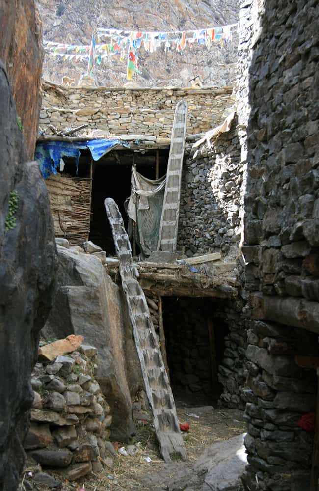
A substantial trail winds westwards uphill and away from the village centre. It’s an easy climb for about 300m (3270m, 1hr from the airstrip) to the top where there are a couple of teashops. Then steep switchbacks down through pine forest and then more open hillside as you pass a few homes and another teashop (1hr). From here continue down but do not go all the way to Dharaphaya, which you can see below. From above the village the main trail heads up the Humla Karnali valley on the true left bank and continues to descend towards the river. In an hour pass through Manjgaon, where there is a teashop and where the trail levels out somewhat about 150m above the Karnali. A final short descent to the campsites at Dharapori (2360m) is in another 1½ hours. There is a small campsite beside the trail as you pass a grove of walnut trees, and two larger, grassy sites after you cross a small bridge over the Hepka Khola. The main village is less than 10 minutes further along the trail.
4
Day 4: Dharapori–Sangrak Kermi 4¾hrs
Follow the main trail passing Dharapori village and in about 40 minutes come to a few large rocks at a trail junction, take the left fork where the route descends a little into a gorge section of valley. The Humla Karnali valley turns left into a steep-sided gorge where there is a series of waterfalls called Chaya Chahara (2hrs), which is a popular lunch spot. From here climb some switchbacks to Dhar Kermi (aka Dhad Kermi, 1hr) and then an easier gradient all the way to Sangrak Kermi (2860m). There are some good trailside campsites beneath the village of Sangrak Kermi which is about 1 hour above the main trail. In the narrow valley beside the village is a hot spring (30 mins from campsites) that fills a knee-deep concrete pool. There is a short-cut trail which is best used on your return to camp as it is a little confusing in dense scrub at a few points. The main route to the hot springs goes through the village.   Humla Bhotia 
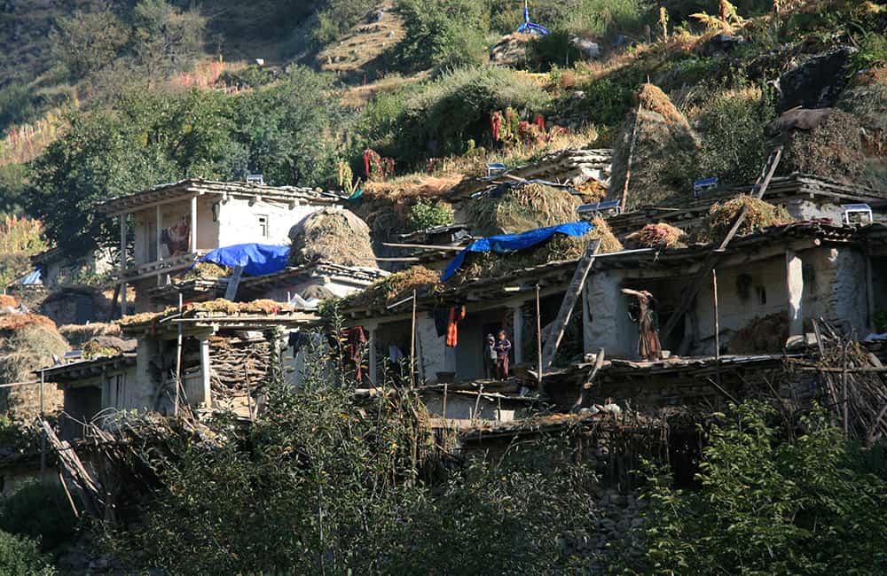
The lower valley areas throughout Humla are inhabited by a mix of Khas, Newar and Chhetri people. The higher regions, however, are home to people who are an amalgam of traders, horse and yak breeders and farmers who have arrived in successive waves of migrations from central and western Tibet over the last 12-1400 years. The largest communities are Baragaon and the villages of the Limi valley who all refer to themselves as Bhotia (people from Tibet). These two regions inter-marry and they believe they share a similar ancestry. Polyandry is practiced, though becoming less common, and weddings are formal agreements that may be made when the children are very young or at birth. The ceremony generally takes two to three days and is attended by everyone in the village. Trade is a vital income with many men going to India during the winter months to purchase metal items, wood to make high quality and sough after bowls, and it is alleged, animal parts especially rare species. Salt and general goods are bought from Tibet during the summer months using mule, dzo and large herds of goats as pack animals. Losar, the New Year festival, is celebrated for 15 days but the community is separated into groups – men for the first 3 days, women over 40 for the next 3 days, younger women for the 3 days after that, then school children for the next 3 days, and the final 3 days is for monks and gompa attendants. Saga Dawa, a festival to celebrate Buddha Enlightenment, is a large feast at which all of the 36 gompa lamas plus a guest lama must be present. If only one is missing then the host (each year a household) must pay a large fine to the village and gompa. Rimche, the main village festival includes lama dancing and is celebrated on the Feb-Mar full moon for 3 days (day 1 is preparation and cleansing). The festival celebrates the victory of Buddhism over minor faiths and features a victorious Padmasambhava mask dance.
5
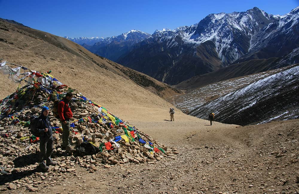
Day 5: Sangrak Kermi–Taplun (Yalwang) 4½hrs
Begin with a long easy ascent on a trail with little shade for an hour to Okharthala, then patchy pine forest for another hour to Salli Kudh (3143m), a minor pass with prayer flags and views back down the valley. The pass is atop a peninsula around which massive cliffs rise from the turquoise Humla Karnali. Descend for 30 minutes (en route pass a flat area with an unreliable water supply) to the Salli Khola, which you cross on a long suspension bridge to a flat area that makes a good lunch spot. Follow the road/trail to a large flat area beside the river – a popular halt for mule trains – in another hour. Then it is a gradual climb to Taplun (Yalwang, 3060m, 1hr), a scattered community on a large south-facing hillside. On the far side of the village is a gompa and school where you can camp in the grounds.
6
Day 6: Taplun–Tumkot 5hrs
The trail winds around a rocky ridge before descending to Yalbang village (30 mins), a pretty Buddhist settlement at the entrance to another gorge section of the Humla Karnali. Sheer rock walls rise from the rushing turquoise river that is said to pre-date the Himalaya. Occasional glimpses of snow-capped mountains dwarf the minor ups and downs as the trail undulates to avoid rocky bluffs. In 1¾ hours from Yalbang reach a small copse near the end of the gorge section. In another 30 minutes cross a wooden bridge to the true right (south) bank then it’s a gradual climb to Muchu village (30 mins) where the valley is considerably wider. Cross a small watercourse to Chhuigan village and then descend gradually to Tumkot Khola and a good campsite (3073m, 45 mins). On the pointy hill above is a Sakya gompa, ask locals if the key holder is around before going.
7
Day 7: Tumkot–Yarig (Yari) 4¼hrs
From the end of the campsite, the trail enters a small gorge and climbs switchbacks for about 400m (3467m, 1½hrs) to a minor pass marked by a cairn and prayer flags called Pathalna by locals. Here the gradient eases and continues to follow the under-construction road to Palbang (3472m, 1hr) where there are a couple of shabby teashops. Then a gradual ascent to the Yari valley where the trail flattens to a cluster of homes (3663m, 1¾hrs) where there are normally fallow fields to camp on. Note the old village is in the valley below (10 mins) but campsites are very limited. NOTE: The route via Nim (aka Nyam) to Kit (via Sarpe La) is now closed as it was a smuggling route. The trail is closed 1km before Kit and any pack animals must be accompanied by a Nepali with a passport as they have to take a trail on the Chinese side of the border – the trail on the Nepal side is only for humans and not accessible for pack animals. Chinese patrol the entire border region and are discouraging locals from yarsagungha hunting and grazing. NOTE: There is a potential high route from Ustan/Nim to Saipal Khola, which locals say is open from May to September. For more information, contact Changchok Lama (from Ustan) who takes yaks to Saipal to trade. He says there are 3 route options over Saipal Dada depending on snow conditions. The first pass (main ridge) is very steep on the Saipal side, cut across the headwaters of the Thado Khola, then easy ascent and descent direct to Saipal Khola. It is important to note that crossing to Tinkar from Saipal not allowed by Chinese who patrol the area as it has a disputed border with India.
8
Day 8: Yarig (Yari)–Hilsa (Yulsa) 6hrs
The trail descends a little past the main Yari village area (10 mins) before beginning the climb up an easy gradient to Jogi Odar (4052m, 1½hrs) where there is a series of tent platforms carved beside the new road route and a couple of teashops. 
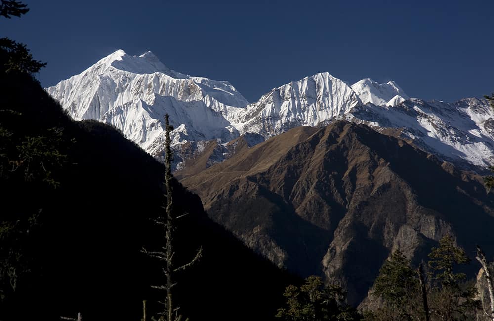
The gradient steepens a little before entering a shallow valley called Shiv Shiv (aka Sip Sip) and has a couple of disused kharka and a potential campsite full of broken bottles. The last section is a steep ascent to Nara La (4560m, 2hrs) with views of Saipal and Muztagh Ata ranges. Descend crossing the road a few times before following it on a long gradual descent across barren hillside. Come to a point where the main trail descends rapidly down scree or you can continue on the longer road route. If you take the scree shortcut, you will arrive in Hilsa (Yulsa) (3647m) in 2½ hours from the pass; the road route takes another 45 minutes. There are no good campsites in Hilsa (Yulsa), but there are two local teahouses and another new one is being built. The sealed road to Taklakot and the Chinese border post are on the far side of the river, so don’t be surprised if you see the occasional Chinese tourists in town!
9
Day 9: Hilsa (Yulsa)–Manepeme 4½hrs
Cross the squeaky suspension bridge, but avoid the border area and climb the scree slope on the far bank for about 320m (1½hrs) to the main trail from Taklakot to Halji. Locals in Hilsa (Yulsa) ask for donations from tourists, saying they want to spend the money to improve the almost non-existent trail up the scree slope. Once on the main trail turn right (east) and continue to climb more gradually for an hour to a high point marked by prayer flags. From here the trail undulates between 3950m and 4080m for 2½ hours to a short descent on switchbacks soon followed by the campsite at Manepeme (3950m) so called because of a large boulder engraved with the Buddhist prayer, Om Mani Padmi Hum.   Day 10: Manepeme–Tiljung (Til Khola) 5½hrs Take your time along the easy trail and see if you can spot Himalayan Griffon and Lammergeyer cruising on thermals first thing in the morning. It will take about an hour to reach the beginning of today’s climb at a point where the cliffs rise 2000m from the distant rumbling of the Karnali below. You don’t have to climb to the top of them as the trail traverses across rocky bluffs and it makes for some great views throughout the day. After 1½ hours you come to a slight basin (4050m) where the main donkey trail climbs switchbacks and another ‘human’ trail traverses right, around cliffs. It is actually not very exposed but those with vertigo should avoid this route. In 30 minutes round a rocky bluff high above the confluence of the Limi Khola and Karnali, and find the remains of a hermitage. There are the remains of a few buildings, some chorten and frescoes nestled against an immense cliff-face, called Chay Gompa. This is a great lunch spot. After a short traverse away from the hermitage, climb switchbacks to a minor pass, Jhonbo La (4230m, 30 mins). In another 20 minutes you join the main trail, which becomes an undulating route to the Til valley. The main ridge into the valley is marked by some chorten, mani stones, yak skulls and horns with Om Mani Padme Hum carved on them. Descend easy switchbacks to some terraces and more chorten where you then turn right and descend to the Til Khola to where it joins the main Limi Khola. There is a large dusty campsite called Tiljung (3577m, 100 mins) at the confluence.
10
Day 11: Tiljung–Halji 2hrs
Cross the upstream bridge, which you can see a little upstream from the campsite, to the true left (south) bank of the Limi Khola and follow an easy trail. Reach another campsite (3627m, 40 mins) surrounded by a wall at the base of vertical canyon walls. The easy trail continues for another hour to a bridge back to the true right (north) bank of the Limi Khola and the outskirts of Halji village (3741m, 20 mins from bridge). The campsite is on the far side of terraced fields away from the village, near the health post.    Til’s Yeti Long ago a woman went to light candles in Til gompa. On the way she was chased by a yeti and only just made it to the gompa. As the yeti was almost upon her she accidentally spilt yak butter on herself and as she tried to rub it off the yeti started mimicking her. As the yeti smeared butter on its face the woman quickly lit a match and set light to the yeti’s hair, which sent it screaming to the hills never to be seen again.   Rincheling Gompa 
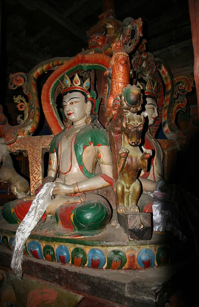
Rinchenling Gompa in the centre of the village belongs to the Drepung Kagyupa Sect, which is linked to gompas in Ladakh. The first building contains a large prayer wheel and statues of Avolkishwara, Sakyatua, Chenrisig and Guru Rinpoche (Padmasambhava). In the ground floor of the west room is a 4m high wooden statue of the four cardinal point Buddhas surrounded by twelve more Buddhas. All are wooden and said to be 1050 years old. Locals believe they were created at the time when the Ladakhi-based Lama Lotsarinchen Sanu Polanamo, the “Great Translator”, consecrated this and 107 other gompas that he built in his lifetime. The shrine room above contains many masks for the Rimche Festival and two statues of Chesuda (one seated on horse and one standing).   Ghost riders Long ago Lama Palme (maybe this is the local name of Lotsarinchen Sanu Polanamo?) arrived in the Limi valley at Takchhe. At the time the residents were fighting each other (there is a long history of feuding in the Limi valley) and the community at Takchhe was the largest and most violent. The locals killed all the Lama’s pack animals and in fear of his life he retreated to a meditation cave. He chanted and threw his prayer beads into the air. As they hit the ground all the locals who had committed crimes died. The Lama led the remaining faithful down to Halji where they were haunted by ghost riders each night. As the ghosts would not leave the residents alone the Lama chanted in a sunny place above the village (some chorten mark the spot below a cliff line) and impeached Chesuda to protect them and the ghost riders went away. To this day it is believed that every family must pray to Chesuda each day otherwise the ghost riders will return. Even villagers who now live in Kathmandu or overseas still pay their respects to Chesuda.
11
Day 12: Halji–Tholing   6hrs
The trail out of the eastern side of the village winds up a rocky valley with occasional grazing areas for 2 hours, before you reach Sunkarni, where a new police post is being built. The craggy canyon continues for another 2 hours to Dzang (aka Jang, 3990m) where there is a large gompa and pretty houses. Immediately after the village the trail climbs and in 30 minutes you reach new road construction and a large alpine valley where there is a small hot springs at 4063m. Continue along the impressive flat-bottomed valley for 1½ hours to a couple of buildings called Tholing (4152m), which is a convenient and comfortable campsite.
12
Day 13: Tholing–Talun (Limi) Khola 5½hrs
The valley broadens before Takchhe where there is another hot spring bubbling beside the river; however, it is not possible to bathe here. There are many deserted buildings in this section of the valley, which was the first settlement in the region. The surrounding hills and large moraine deposits make this feel like a dead end, but to your south what may look like patches of snow on moraine is in fact a massive sand dune over which you must climb to a large shallow lake (1½hrs). If the lake waters have receded, head straight for a trail that climbs above the eastern shoreline. Otherwise it is quite a long walk around boggy ground to meet the trail. The trail doesn’t climb much above the shoreline and eventually descends at the far end of the lake to some scattered kharka (4173m, 1½hrs). Ahead, the Talun Khola valley rises in a series of moraine steps created by intersecting glaciers, which have long gone. Each is an easy climb to a flat section of valley and in 2 hours you reach some rocks painted with ‘Limi Campsite’ but, if you have the energy and time available, continue for another 30 minutes to a slightly higher camp at 4380m.
13
Day 14: Talun (Limi) Khola–Salli Khola 4hrs
Get an early start for the short walk to the bottom of a long series of switchbacks that climbs to a cairn (4834m, 1¾hrs) where there are great views of the Talun valley and Lubuchela Himal. Here the gradient eases as you wind through some lumpy moraine to the base of the final climb to Nyalu La (5001m, 45 mins). Descend past the Selima Dada, a pretty turquoise lake, to a small moraine lip at its southern end (4565m, 45 mins). A steep and rocky descent into a large flat-bottomed valley and potential campsite (4100m) takes 45 minutes. If you want to catch good views of the Saipal Himal, it’s best to camp here rather than continuing down the valley.
14
Day 15: Salli Khola–Sangrak Kermi 5½hrs
Follow a section of road that heads down the true left (east) side of the valley floor before descending through pine forest to another potential campsite beside the Salli Khola (3811m, 1hr). It is now a delightful descent through silver birch and pine forest with views of the Saipal Himal to your south. After 1½ hours, pass another potential campsite (3387m) beside the trail. From here there are occasional steeper sections as the valley gradually narrows. At 3109m (45 mins) cross a wooden bridge to the true right (west) bank and descend a little further before climbing to the Salli Khad pass (3144m, 35 mins), which you crossed on day 5 of this trek and where you rejoin the main trail to Simikot. It is an easy 1½-hour descent to the campsites at Sangrak Kermi (2860m).
15
Day 16: Sangrak Kermi–Simikot 6½hrs
You may choose to break today into two short sections but if you have the energy it is not too far to get to Simikot by the afternoon. Follow the main trail as you descend past the waterfalls at Chaya Chahara (1¾hrs) and then on to Dharapori (1hr). From here it’s all up to the minor pass above Simikot (3hrs) before the final 30-minute downhill to the teahouses and airstrip.
16
Day 17: Simikot–Nepalgunj–Kathmandu All Day
There are daily flights from Simikot to Nepalgunj and you should try to book seats on the first flight so that you can connect easily to Kathmandu the same day.

GHT India Short Treks

GHT Bhutan Short Treks

GHT Immerse Mustang

GHT Immerse Dolpo

GHT High Bhutan

GHT High India Himalaya

GHT Alpine High Route

GHT High Nepal Traverse

Rolwaling and Tashi Labsta

Upper Dolpo Circuit

Book Now

For more information. Please complete this form.

Ask Expert

For more information. Please complete this form.