1
Day 1: Kathmandu–The Last Resort 4hrs
The drive from Kathmandu up the Arniko Highway is best done early in the morning before the traffic becomes too heavy. If you reach Barhabise within 3 hours you have had a fast trip: the public bus can take much longer. If you are going to stay in the Eco-Himal lodges you will need to alight at Barhabise and trek to Karthali where Mr Sunil Rokka runs a teahouse and can organise a local guide for you.
However, if you are planning to follow the route described, continue to The Last Resort (1170m, famous for the highest bungee jump in Asia), about an hour from Barhabise.
2
Day 2: The Last Resort–Kaymarle Kharka 5½hrs
There are many confusing forest trails from the Marmin Danda to Tinsang La, so you should organise a local guide at The Last Resort. From The Last Resort, cross the bridge and climb stone steps to Tyanthali village (1390m, 30 mins). At an old service road, turn right and continue past the village school. About 400m beyond the school take a trail that turns up hill (left) and slowly climbs as it traverses to Sakhuwa village (1480m, 40mins).
After passing through some scrubby forest the trail swings around a corner to some broad terraced fields belonging to Kati village (1520m, 20 mins). Stay close to the base of the steep hillside above, which will involve stepping up from terrace to terrace. Do not enter the village. Continue on a trail that heads across a small stream on the northern side of the village and then climbs into scrubby forest that covers the hillside above. You will now climb a well-worn switchback trail to Mandre (2180m, 2½hrs).
From above Mandre village, take a major trail that turns south-east (right) where you will find the gradient eases as it traverses the south-facing slope of a prominent hill. In another 1½ hours you will reach a natural saddle between the Khagdal Khola and Gulche valleys. Camp on the terraces or saddle (2285m; Finaid: Barhabise, sheet: 2785 04, ref: 925 811), there is a permanent water source on the north side (Gulche village side) where there are a couple of houses.
3
Day 3: Kaymarle Kharka–Sano Jyandan 5½hrs
Today you leave the villages behind and head up to a large forested ridge, which ultimately leads to Tinsang La. Take your time and enjoy the views; if you begin early each day there is a good chance of seeing red panda. Follow a trail to the east that heads up from the kharka along an obvious ridge. As you climb, the forest becomes thicker and after about 400m of ascent (1¾hrs) the trail veers away from the ridge and onto the northern slopes of the Nambarjun Danda.
After 40 minutes you reach a dry watercourse which you should climb to another saddle and potential campsite at Sindurche Kharka (2780m, 1hr). The trail from the kharka continues east, back up onto the forested ridge. The trail sometimes butts up against the precipitous edge of the ridge, with views down to the Khagdal Khola 700m below. As you continue along the ridge the trail rises and falls for short sections and there are small seasonal shelters used by locals when they take their cattle to the high pastures during the monsoon months. Do not take any cross trails, stick to the obvious track as close to the top of the ridge as possible.
After about 2 hours you will arrive at a kharka with two stone shelters in a large saddle, Sano Jyandan (3127m), where there is permanent water in the rhododendron-forested gully to the north of the campsite.
4
Day 4: Sano Jyandan–Tinsang Kewa 4hrs
Head due east on a trail that traverses beneath a forested hill to a very large kharka with many stone shelters called Palati Jyandan (3210m, 30 mins).
Note: camping is not advisable here as water is scarce during the trekking seasons.
Continue to the far side of the kharka and re-enter the forest. You soon come to the head of a dry watercourse (25 mins) which you should follow as it winds down between two hills and away from the ridge. A further 30 minutes from the kharka, the trail swings east (right) and away from the watercourse and into an old-growth rhododendron forest. Continue on a good trail, which in 20 minutes from the watercourse brings you to Marmin Jyandan (3250m), where there are a few stone shelters but not permanent water. From this kharka the trail heads out across a steep rocky hillside. You should check the weather before beginning, as rain will make sections more difficult.
Climb back onto the ridge for 30 minutes before the trail slowly climbs and traverses a steep rock- and grass-covered hillside. In 45 minutes, you will connect with a long north–south ridge, which leads to Tinsang La. You should be able to see the motor road leading up to the pass about 2km away.
Once you join the main ridge you are back in rhododendron forest, but do not descend all the way to the pass. Instead follow a large trail that swings east, away from the ridge, and in 20 minutes you drop down to a series of plateaus that lead to a campsite at Tinsang Kewa (3266m, 15 mins).
5
Day 5: Tinsang Kewa–Bigu Gompa 4½hrs
You will frequently cross the road as you descend via multiple short cuts through the forest. In 2¾ hours you will reach the hamlet of Rupthan (2400m) where you cross a small bridge. From here the trail begins to climb back into the forest on an easy gradient. A local guide is useful to pick the right combination of short-cut trails up to the broad plateau of Bigu Gompa (2516m, 1¾hrs), and the Eco-Himal teahouse and campsite.
Bigu Gompa is a nunnery dedicated to the thousand-armed Buddha, Avalokitesh-wara (Compassion of all Buddhas), who is the all-seeing, all-knowing remover of obstacles. The nuns are happy for visitors to attend morning prayers; a donation is appropriate for even brief visits.
6
Day 6: Bigu Gompa–Loting 4hrs
From the Sherpa village of Bigu, there are two routes to Loting, the main trail descends to the Pegu (Amatol) Khola (1700m, 2½hrs), which it crosses and then climbs a little before descending to a bridge over the Sangu Khola and then climbing to the Gurung village of Loting (1768m, 80 mins) where there is an Eco-Himal teahouse and campsite.
Alternatively, head east and gradually descend to the village of Alampu, which covers the south-east-facing hillside above the Kotheli Khola. A steep trail descends through the village to a bridge (1732m, 2hrs), which you should cross to a small hamlet. Follow the river downstream for about 30 minutes to just before the confluence with the Sangu Khola and veer left to climb about 200m through scrubby forest. In an hour you round the hillside and enter Loting.
7
Day 7: Loting–Laduk 6hrs
A trail leads around the edge of some terraced fields before descending slightly to the Dorun Khola to the south-east of Loting. Climb the far bank past a large chautara and continue ascending a gradual gradient around a hillside, which is steeper on its southern flanks.
There are many trails around the hill and you should try to stick to the highest obvious track. Descend to and then cross a seasonal watercourse before climbing easy trails to Chilingkha (1839m, 2hrs), where there is an Eco-Himal campsite but no teahouse facility.
Climb through the village to another scrub-covered hillside, which has recovered from a large bushfire at the beginning of 2009. The trail traverses around the hillside to the small village of Chyasarpa (2020m, 80 mins), where you descend to another watercourse. From here the trail becomes broader as it passes through a small forest and then climbs an easy gradient all the way to the Eco-Himal teahouse and campsite at Laduk (2050m, 2½hrs).
Note: from Laduk it is possible to descend to the road at Singati and return to Kathmandu within 7-8 hours.
8
Day 8: Laduk–Orangdanda 4hrs
A broad trail climbs an easy gradient from Laduk through pine forest that covers most of the hillside above. In 80 minutes, you will reach a ridge above Bulung where you might be lucky and catch your first views of the Gaurishankar Himal. Descend to the village (1890m, 15 mins), where there is a community-owned campsite.
A trail winds around the top of the village to a chautara with two chorten where you join another trail from the valley below. Take the left fork, which heads north and descends to a stream before climbing an easy gradient across a grassy hillside to the small village of Yarsa (2020m, 45 mins). The trail descends to a small dry watercourse on the northern side of the village, which you have to climb for about 40 metres to a track that swings right and climbs to terraced fields.
In about 50 minutes you enter the ridge-top village of Orangdanda (2029m) where there is another Eco-Himal teahouse and campsite. There are great morning views of the Gaurishankar Himal from this teahouse, which is the last one along the Rolwaling trail. From here you can descend to the road in the valley below (about 700m down, 3hrs) where you can return to Kathmandu.
Note: To continue towards the Rolwaling Khola from this point requires camping equipment.
9
Day 9: Orangdanda–River Camp 4¾hrs
Looking north from the Eco-Himal teahouse you will notice that the homes have changed from the previous days as you are now entering Tamang communities. From the entrance to the lodge, the trail contours around a broad, terraced hillside to a large landslide. There is a good trail across the very top of the landslide, do not cross lower down. Once on the far side, descend terraces to a stream, and then climb a little to the village of Deulang (1900m, 1¼hrs). You soon reach the top of the large village of Thare where you should follow the main trail that descends through the centre of the village. As you reach a cluster of homes towards the bottom of the village (1820m, 45 mins) the trail swings north and descends an easier gradient to a small Sherpa village above Gongar (1430m, 1¾hrs), which is in the valley below. Stone steps lead down to the road, which you will need to follow for about an hour to a bridge at Chetchet (1377m). Cross the Tama Kosi to a campsite on the far bank. If you are feeling strong and have enough time, you could combine today with tomorrow’s trek.
10
Day 10: River Camp–Simigaon 3½hrs
From the campsite a stone staircase climbs up and around a rocky spur that juts into the river valley. Climb steps which switchback for about 400m to the lower homes of Simigaon village (2hrs). Once you reach the first terraces the gradient eases as the trail winds between homes. It will take another 1½ hours to reach the few teahouses and campsite (2036m) on the ridge above the village, where a new gompa is being built.
11
Day 11: Simigaon–Dokhang 6hrs
From the gompa you can see the trail winding around the hillside to the north-east to a minor ridge (30 mins) where the trail descends through forest to a small kharka about 30m above the Rolwaling Khola (2060m, 40 mins).
Note: if you are doing this route in reverse there is a trail junction about 10 minutes into the forest from the kharka – you must take the left fork and climb from here, do not descend to the river.
From the kharka the trail begins a long and sometimes steep climb through forest. After 2 hours you should reach a large waterfall, which has a cool pool of water to soak your feet in if it’s a hot day. Continue to climb for another 2 hours to Gyalche Kharka (2832m) where there is a small shop and campsite. It is now an easy descent through forest and then beside a small stream to the spacious campsite at Dokhang (2791m, 40 mins).
12
Day 12: Dokhang–Beding 5¼hrs
After the steep climbs of yesterday, the trail gradient is now much easier as it winds a course along the south bank of the Rolwaling Khola. Rhododendron, pine and juniper shade wildflowers in mossy glades, and the river cascades beside the trail. There are a few small landslides to cross, which make ideal places to spot birds catching insects above the river.
In 2 hours, you should reach a bridge to the true right (north) bank of the river, and in another 15 minutes you will reach a bridge over the Themlung Khola, which is surrounded by cairns. If you stand in the middle of the bridge and look up the steep ravine to the north you will see Gaurishankar looming overhead.
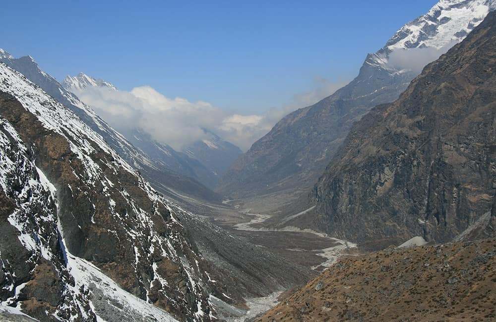
From the bridge the trail climbs a few hundred metres away from the V-shaped river valley and towards the U-shaped glacial valleys above. As you reach the top of the climb you will notice that juniper and fir trees become more common, and the snow and ice-covered bulk of Tsoboje peak fills the end of the valley ahead.
The gradient eases once again and you should reach the village of Nyamare (3550m) in another 2 hours. Beding (3740m), where there are teahouses and a campsite, is now less than an hour away.
13
Day 13: Beding–Na 4¾hrs
Today is a relatively short and easy trekking day, so take a little time to visit the gompa in the village. It is said that a Buddhist monk came and lived in a cave behind the gompa before the village was established. To mark the site, a chorten was built and to offer a khadag to the chorten is considered to bestow good luck on the giver for as long as the scarf remains attached. Please offer a donation to the gompa if you want to admire the wood-panel frescoes inside.
The trail climbs an easy gradient away from Beding through miniature fir trees along a sometimes rocky trail. After 2½ hours you should notice that the valley is becoming broader and flatter and some large boulders dot the landscape. One of the boulders has been carved with the Buddhist prayer, Om Mani Padmi Hum, and must be the largest single mani stone anywhere. Just beyond is another boulder with a large painting of Padmasambhava (aka Guru Rinpoche, the Lotus Born, who first took Buddhism to Tibet in the 8th century) and a small shrine.
Na (4180m, 2¼hrs) is a scattered village on a broad alluvial fan where there are many camping options and teahouses.
14
Day 14: Na all day
It is a good idea to take a day to acclimatise in Na, and there are a couple of good day trip options.
The most popular day trip is to head up valley to a small kharka and then turn right on a small trail to Yalung Peak base camp (5hrs’ return trip). Alternatively, climb to the end of Tsho Rolpa lake for views of Kang Nachago above Na (4hrs’ return trip).
15
Day 15: Na–Kabug 5hrs
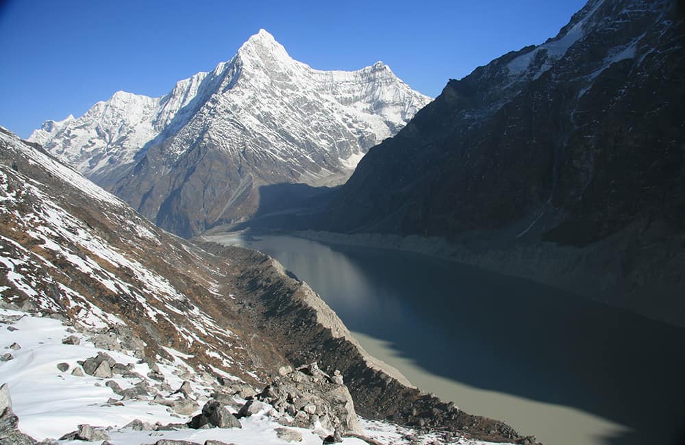
The trail above Na climbs a slight gradient to a bridge over the Tsho Rolpa outflow. From here you have two options: the main trail ascends an ablation valley to the south, alternatively, climb the terminal moraine wall that acts as a dam for the lake. Once at the lake, the trail winds around and descends slightly to the ablation valley to the south.
About halfway along the side of the lake, at Chhukyima there are a couple of small teashops run by locals from Na and a good campsite (4580m, 3hrs). Continue to the end of the valley and climb a steep hillside for 250m (1½hrs) to a viewpoint of the lake and surrounding peaks. It is now a short descent to the broad sandy plateau of Kabug campsite (4820m, 30 mins).
16
Day 16: Kabug–Glacier Snout 6½hrs
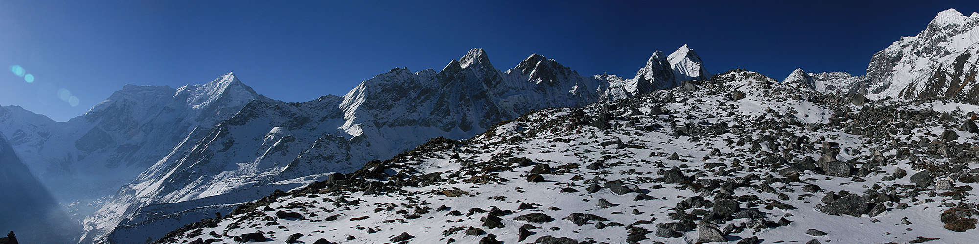
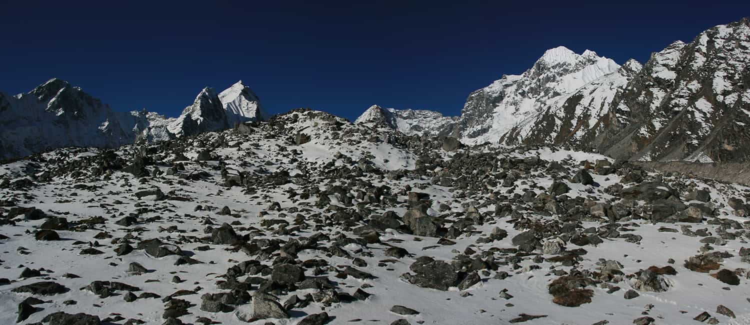
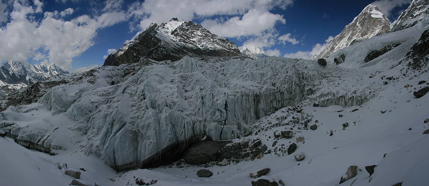
Before you begin today it is worth having a good look at the Trakarding Glacier below and try to identify potential routes across it – groups often get separated here and finding each other can waste a lot of time. Cross the plateau to the furthest eastern corner above the glacier and then descend a loose earth trail to the southern edge of Trakarding Glacier (4735m, 40 mins). From here there are a number of routes that cross the glacier. If you have started early in the morning, the most obvious trail crosses almost immediately to a trail that then ascends the northern side of the glacier. However, this route is extremely prone to rockfall from mid-morning onwards. Alternative routes begin in about 30 minutes and again in an hour up the south side of the glacier. As with all glacier crossings care should be taken at all times, and your party should remain together throughout the crossing. Once on the north side of the glacier, follow a trail that leads to the snout of Drolambu Glacier. There is a large campsite at place called Noisy Knob Camp (4880m, 3½hrs). If you have time, continue to the far side of the glacier snout to where a rock scramble (use a hand line for porter safety) brings you to another campsite beneath ice cliffs (5085m, 2hrs 20 mins).
Note: many maps show a rocky route up the western side of the Drolambu Glacier snout, this route is rarely used due to rockfall danger.
17
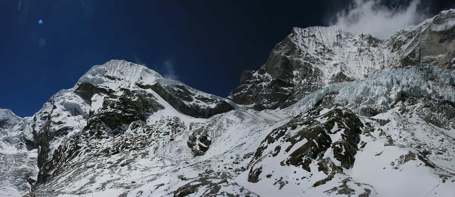
Day 17: Glacier Snout–Tashi Labsta Camp 6½hrs
On the true left side of Drolambu Glacier (east) a stream has carved a rocky trail, climb this to access a glacial ablation valley (5350m, 1hr). Stay in the bottom of the ablation valley all the way to the base of the glacier flowing down from Pachermo (5435m, 2½hrs). The snout of this glacier has receded and you might need to put in a hand line for porter safety. Once onto the glacier, climb a natural ramp that leads all the way to the summit of Tashi Labsta (5760m, 3hrs) – be careful of crevasses! The pass is a rocky ridge, which is normally reached by climbing an icy slope on the lower flanks of Pachermo. From the top of the pass the high camp is beneath an overhanging rock-face about 100m down from the summit.
Note: close to the base of the overhang is safe from rockfall, whereas camping on the glacier below is dangerous.
If there is already a group camped here, head a little higher on the northern flank of Pachermo to a snowy plateau that is often used as a base camp for groups climbing Pachermo. The strong social and economic links between the Rolwaling and Thame valleys mean that you could even meet a wedding party camped up here during the summer months!
18
Day 18: Tashi Labsta Camp–Lake Camp/Thyangbo Kharka 5-6½hrs
From the high camp a trail traverses due east along the base of south-facing rock-face of Agole Peak. In less than an hour you should reach a broad notch in the cliff-face below, you will probably need to set a safety line for porters. The descent is about 70m to an obvious trail down rocky slopes to the campsite at Ngole (5130m, 2hrs 20 mins).
A steep trail leads down moraine from the camp to a shallow basin where there is a trail junction. The fastest route down to Thyangbo Kharka climbs the smaller moraine wall on the far side (true left) of the basin and descends around a black cliff-face before winding down the true left (northern) side of the valley to Thyangbo Kharka (4320m, 3hrs). Alternatively, turn right in the basin and head down to a series of three lakes where you can camp beside the largest, Parchemuche Tsho (4780m, 1½hrs).
19
Day 19: Lake Camp/Thyangbo Kharka–Thame 2-4hrs
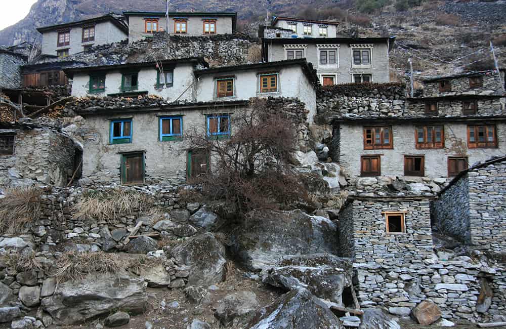
The trail down to Thyangbo Kharka (4320m, 2hrs) is along the true left (northern) side of the valley and provides good views of a series of pinnacle-like peaks to the south. From the Kharka, where there is a teahouse and good campsite, it is an easy 2 hours, passing the famous gompa, down to Thame (3820m).
20
Day 20: Thame–Namche 2½hrs
The trail from Thame descends to the Bhote Kosi and crosses a bridge at the end of a canyon section carved by the river. The locals believe this is an auspicious place and have painted the rock-face above the bridge with Buddhas and prayers. The trail now climbs a little before settling into an easy downhill gradient to Thamo (3480m, 1hr). Cross the Thesbu Khola and continue on a broad trail through pine forest all the way to Namche (3440m, 1½hrs) where you will arrive next to the new helipad and many painted mani stones on the hill above the western side of the town.
21
Day 21: Namche–Phakding 4hrs
The trail from Namche leaves the southern entry to the town and descends almost 800m to the Bhote Kosi below (2hrs). The trail then winds down the river valley first to Monjo (2840m, 1hr, the Sagarmatha National Park entry post), then Benkar (45 mins) and then to Phakding (2610m, 1hr), where there are numerous teahouses.
22
Days 22-23: Phakding–Lukla– Kathmandu 4hrs
An easy undulating trail leads to Ghat (2590m, 1hr) where there are some fine painted mani boulders. It is then an easy climb to Lukla (2840m, 3hrs) where there are many teahouses and the famous airstrip with regular flights to Kathmandu. See Everest Base Camp, Cho La and Renjo La, pp000-00 for more information about the trail from Thame to Lukla.