1
Darchula - Dar - Urting 2hr drive + 3.5hrs trek camp 2323m
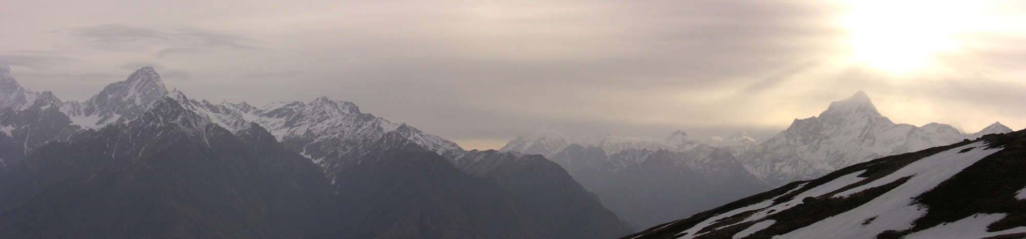
After organising your permit in Pithoragarh, Darchula or Didihat you might have enough time to drive up to the ITBP post at Sobla (1 hour and 30 minutes) where you need to register, continue to the roadhead at Dar (20 minutes) and then hit the trail. As there is no campsite at Dar (2100m) you have to start trekking, but in an emergency there are a few concrete rooms you could rent for the night. Dar is also a spot to hire local porters but don’t expect them to carry more than 20kg. From Dar, continue along the road for about 1km to a small mandir at a point where the road becomes a chiseled trail across an enormous cliff. Follow the trail and beyond the cliff and begin enjoying views of snowy peaks above cascading tributaries. The first village, Bongaling (2241m, 1 hour and 30 minutes) is above the trail and you only know you’re there as you pass a couple of small shops (one offers lunch). Locals say it is possible to camp near the village above. A small trail-side mandir in another 1 hour has an interesting story: Many years ago (or guide said 20) a group of ITBP officers were riding down the trail when one of them fell into the river and drowned. In a fit of anger towards the God of the mandir one of the dead mans’ companions fired his gun at the mandir and put a hole in the largest bell. You can clearly see the bullet hole. It is said that he also died the same day. An easy undulating trail through patches of mixed forest (look for red rhododendron flowers) includes some sections chiseled from cliff faces before reaching an impressive waterfall in 1 hour and 30 minutes. Climb for 30 minutes (130m) to the dhabas and campsite of Urting (2323m).
2
Baling 5hrs camp 3135m Alt Var 810m
The trail remains on the true right side of the river for the next two days and passes through mixed forest with plenty of rhododendron (red and pink flowers). You will need to register at the ITBP post beneath Sela (2489m, 40 minutes) but do not cross the bridge to the village. From here the trail begins some up and downs on a sometimes rocky trail. Look for small shrines to departed loved ones beside the trail. Yosung Kharak is a pasture where some steep tributaries make the valley wider and a potential campsite (2655m, 50 minutes). Continue along many small up and downs through pine, oak and rhododendron forest above the river before once again descending to its bank and another bridge (to Chal). Do not cross the bridge but begin an easy, sustained climb to a large campsite and then more steeply up to Nangling (2870m, 1 hour and 30 minutes). Note that the peak at the head of the valley to your west is called Nangling, whence the village receives its name. There are some dhabas and a level (but dirty) area at the top of the climb. It is also possible to camp in the small school grounds. The trail is ascends slightly before a climb up and around an ancient forested moraine wall beyond which is Baling (3135m, 2 hours). The village is in two halves spilt by a shallow gully. The main part, including the ITBP post (register here) is on the far side of the gully. There is also a concrete community hall where visitors can stay, or there are many potential campsites around the tightly packed village.
3
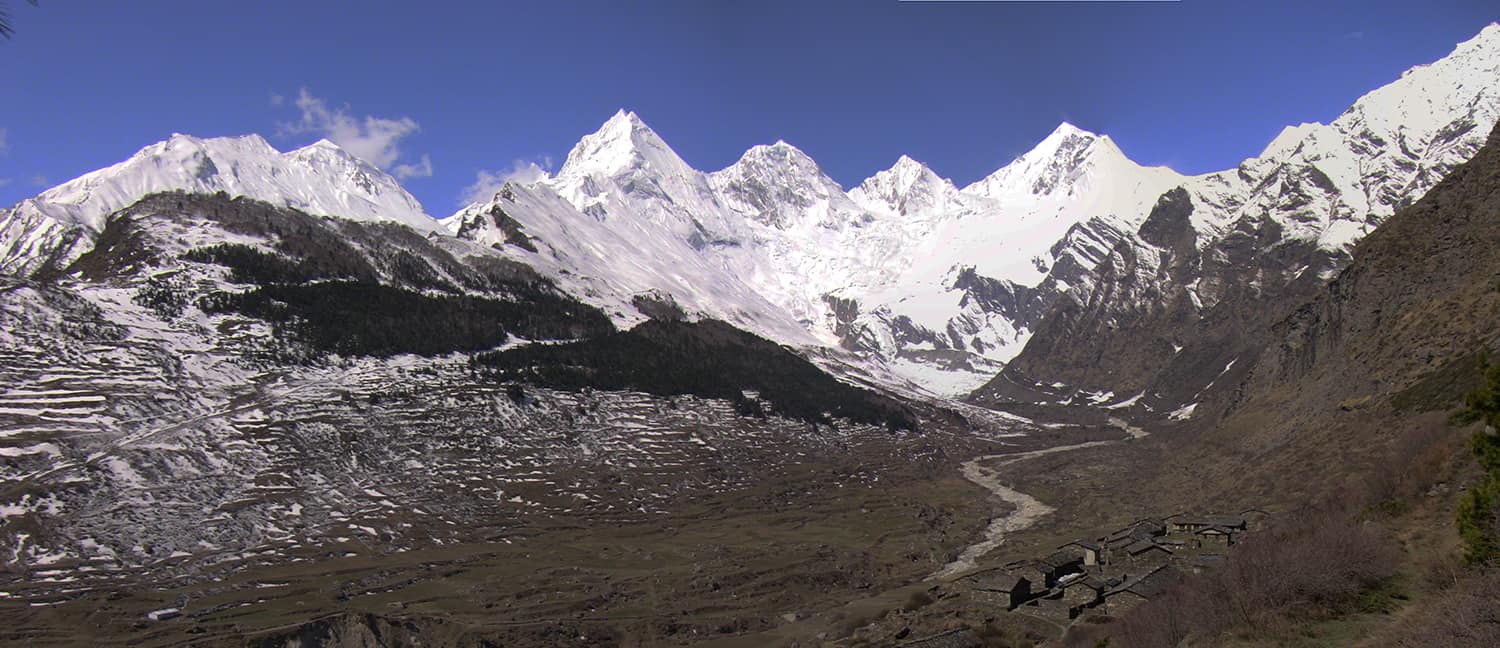
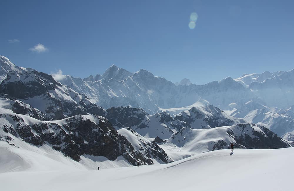
Marcha / Sipu 5hrs camp 3383m Alt Var 250m
You are now in a large alpine U-shaped valley and the trail gradually ascends the true right hillside – the trail can easily be seen from Baling heading up valley. After crossing the hillside section you cross a large flat area where some new tourist shelters are being built. The summit of one of the Panchchuli range can bee seen up a steep valley to your left. A moraine ridge forms the northern boundary of the flat area and on top is Song (aka Son) village, which you do not need to climb to! There is a trail that contours around the end of the moraine into a large basin gauged by a receded glacier. On the southern side of the basin is Tuktung (3258m, 3 hours and 15 minutes) and opposite is the larger village of Tungtu (20 minutes) – towering above both at the head of the valley is the very impressive Panchchuli massif. The view is enough to probably make you want to stop and camp in this valley and explore the many madirs and viewpoints. The Panchchuli HimalThe five Panchchuli mountains range from 6312m to 6904m and get their name from the Hindu epic, the Mahabharatra. The story says that the five Pandava brothers stopped to cook their last meal here (panch-chuli means five-stoves) while on their way to heaven. No wonder it’s a popular pilgrimage place during the August full moon when a large mela is held. Beyond Tungtu is a section of pine and fir forest and the stone paved trail up to a collection of mandirs above. There are good views of four of the Panchchuli group from here. A slight descent through the forest brings you to a broad open valley, ahead can be seen another ancient moraine wall stretching across the valley. On the south-facing slope is Dokar village and above, on the ridge is another ITBP post. You might be lucky and the sentries may come down to inspect your papers. If not you’ll have to go up there and register. We were told at this point, ‘Do not photograph any villages or the valley bottom, but you can snap the mountains and snowplaces’! On the northern flank of the moraine ridge is Tidang village where the only campsite is the school grounds. If you do not have permission you cannot go beyond Dokar. Before entering Tidang village follow the trail that crosses the river and then climbs slightly to Marcha (3383m, 1 hour and 15 minutes). This is a pretty little village with a camping area on your right before you pass the first collection of homes. An easy trail heads up valley and in 40 minutes cross back over the Darmaganga and climb to Sipu (3390m, 20 minutes). You cannot proceed to the next ITBP post at Kharsa without special security clearance and an inner line permit (ILP) but you can trek up to the entry of the Ralam Dhura valley, which is only 1 hour away. Otherwise retrace your steps to Dar (6 hours to Nangling, then 5.5 hours to Dar) where this itinerary begins again.
4
Darchula – Sumdum 4hrs camp 2417m Alt Var 600m
Cut down through the village to the dirt road below rather than following the dusty road switchbacks. Continue down the road to where it winds between a large boulder and hillside (note small mandir next to the boulder) and just before a bridge turn sharp right onto trail and begin a steep switchback climb for about 100m passing a few small homes. Above the houses is a small disused concrete canal channel for a hydro scheme that never seems to have been finished. It takes a little balance now and then but follow the outer wall (not the hillside wall) as it traverses steep hillside. The canal has many pools of water fed from streams above so it has become a mini ecosystem with flowers and dragonflies. It’s a pleasant walk watching nature gradually reclaiming man’s efforts all the way to Tejam (1964m, 1 hour and 30 minutes, ref: N30º03’54.7”, E80º34’16.0”). There is an army and forest department post here but you do not need to register, instead pass through the village to a broad flat-bottomed valley which is easy to cross in dry season. If you are here during monsoon there is a high trail around the edge of the valley. Where the valley begins to narrow the trail climbs up to the main hillside route that offers shade in pretty mixed forest. The valley swings north and you pass the small hamlet of lower Kartha (1 hour) before a short climb and descent over a rocky bluff. Once back beside the river you’ll come to a trail junction where you turn left (20minutes, note that the right hand trail goes to Gam). The next forest section is alive with birds including magpies, tree-creepers, woodpeckers, many colourful finches and if you are lucky a kingfisher or two. The trail is good and recently improved in many areas by the friendly villagers of Sumdum (2430m, 1 hour and 20 minutes, ref: N30º03’55.7”, E80º31’28.8”).
5
High Camp 3.5hrs camp 3347m Alt Var 930m
The trail heads through the centre of the village to a cluster of homes at the edge of the cultivated land. From here you pass through the last couple of fields and then enter rhododendron forest (many shades of pink and red flowers) and you soon reach a trail junction. Head right and begin climbing switchbacks. After roughly 250m of ascent you leave the forest and ascend steep grassy hillside. There are a few sections of switchbacks with short traverses inbetween before arriving in a shallow basin where herders have some huts. On the far side of the basin is a stand of oak trees that you climb through to a minor ridge and another more substantial hut (roughly 3000m, 2 hours). The trail climbs the ridge briefly before making easy progress traversing beneath the rapidly climbing ridge and then suddenly you emerge from forest to the large grassy pasture of Bihangling (3038m, 30 minutes, ref: N30º03’40.5”, E80º29’47.7”). This is by far the best campsite along the trail although there are two others before the pass you may choose to stay here. The trail heads out the far western side of the pasture into forest and traverses to a stream in a few minutes. Cross the stream and climb a steep scrubby switchback section that leads to an impressive area of pine forest and an easier gradient. Beyond the forest is more open hillside although sloping it does offer some campsites (3347m, 1 hour, ref: N30º03’45.3”, E80º29’21.1”).
6
Kulka Ghad 7.25hrs camp 3400m Alt Var 2350m
From the high end of the pasture the trail traverses for about 15 minutes before a slight descent to a stream that flows down from the pass ridge above. After crossing the stream ascend a steep grassy slope and then through rhododendron forest on an easier gradient and in about 45 minutes you reach open grassy hillside. The sometimes steep trail leads up and slightly left (southwest) to the main ridge which is broken up with rocky outcrops. The Balsi Khal (3903m, 1 hour and 30 minutes from treeline, ref: N30º03’02.1”, E80º28’25.2”) is marked by two square cairns, some tridents and scraps of red material. Head down a steep gully on the far side of the pass where the trail has largely been washed out by runoff. As you reach the valley floor the trail heads a little downstream and then rounds the end of an extensive rhododendron area before heading upstream. At some point you need to cross the river to reach a small and slightly sloping campsite (3434m, 1 hour and 30 minutes, ref: N30º03’37.6”, E80º27’46.7”). After crossing a small water gully ascend steep grassy hillside for 45 minutes when the gradient gets much easier on the approach to the pass ridge. It is not possible to see the pass from below as you must first wind up and across undulating hilltop to finally reach a natural saddle on the Guin Dhar (4031m, 1 hour and 15 minutes, ref: N30º03’46.8”, E80º26’58.7”). Descend another steep gully on the far side of the pass and as you get about half way down to the valley floor you should be notice a collection of herder’s shelters to your left where you should camp (roughly 3400m, 1 hour and 15 minutes).
7
Bona – Munsyari 8hrs + 2hr drive camp 2200m Alt Var 1580m
A difficult to find trail descends through forest to the Kulka Ghad, which you cross and then ascend a little to the sloping pasture of Daharti Kharak (3098m, 1 hour and 30 minutes, ref: N30º03’52.3”, E80º25’39.0”) and the beginning of a much better trail. After a short climb across the pasture you enter a steep-sided gully cut by a stream. Cross the stream and ascend switchbacks for about 200m to the top of a spur when the gradient eases. You now cross the top of more spurs to reach Daharti Khal (3440m, 1 hour and 15 minutes, ref: N30º03’23.6”, E80º24’41.7”). A deep valley lies below and the first part of the descent has some treacherous sections; loose landslides, some rock scrambles and exposed trail. After roughly 500m of descent enter mixed forest where the gradient eases but still has some short steep sections. A large saddle is a popular shepherd’s rest in 1 hour and 15 minutes. In another 45 minutes you reach the outskirts of Bona (2100m) and the main Paina Ghad valley trail. Once you meet the main trail head downstream (left) through the village, where there is a small lodge and campsite. As you leave Bona the trail descends through a steep gully and then climbs again to traverse (do not descend to the river) until you reach the confluence with the Jinba Ghad near the village of Golpha (2 hours and 30 minutes). The trail now descends about 500m to the valley floor where there is a teashop before a suspension bridge. Cross the bridge and walk about 15 minutes downstream to the service road of a hydro project. If you haven’t pre-organised a jeep you may to wait for a few hours for one to arrive. Alternatively, walk another 4km down the service road to the main road to catch a bus or jeep to Munsyari (2 hour drive, 36km further).
8
Munsyari to Rur Khan Tal 4.25hrs camp 3470m Alt Var 1230m
It's a 15 minute drive (Rs350 for a jeep) up to Balati Bend (2700m) where the trailhead is marked by a forestry sign. Follow a good stone paved trail through oak and rhododendron (pale pink to crimson flowers) forest. The state government tourist lodge (3231m, 1 hour and 45 minutes) is partially under construction but offers fantastic views of Panchchuli on a clear afternoon (best in October to December).Khaliato Pass (3467m) is another 35 minutes above on a broad, grassy ridge that is an even better viewpoint than the government lodge below. Once on the ridge (marked by a cairn) head north (right) where some sections of trail are marked out for construction. Head up to and the across a small saddle to a high point of 3702m in 1 hour (ref: N30º03'46.3", E80º11'18.3). Ahead the ridge curves away a little to your left and a small lake, Rur Khan Tal (3470m, 1 hour) lies surrounded by rhododendron shrubs below to your north. This is a great place to camp for morning views from the pass as the next campsite on the other side of the pass is about 1 hour further.
9
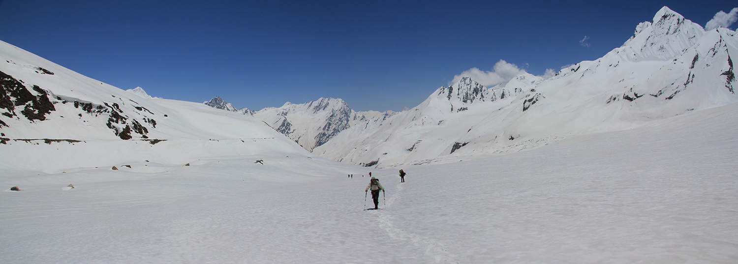
(above) Namik 5.5hrs camp 2945m Alt Var 1800m
You will have to wait for quite a while for the Panchchuli range to come out of silhouette but the early morning views of the Nanda Devi range are great from the ridge above camp (3515m, 20 minutes). The 'pass' is in a small saddle along the ridge (3456m, 10 minutes, ref: N30º04'54.7", E80º10'19.9") and marked by a cairn decorated with red cloth and a trident. The descent is through rhododendron forest and across large grassy pastures that gradually gives way to mixed forest. There is a pasture with good water (3190m) after 40 minutes and another at 2853m in another 45 minutes. Cross a bridge (2552m, 45 minutes, ref: N30º05'20.8", E80º08'55.3") and immediately begin climbing switchbacks on a rocky slope to a spur (2841m, 20 minutes) where you can see the road near Birthi. A short section of easy undulating forest trail (20 minutes) leads to another climb in a stream gully (2689m, 50 minutes) at the top of which is a flat area and the main stone-paved trail from Birthi to Namik. Turn right (uphill route) onto this trail and climb about 300m to Sursongri Pass (3138m, 50 minutes, ref: N30º04'44.8", E80º07'23.7"), which is marked by a small shrine, bells and tridents. Almost immediately after the pass is a grassy flat area where the trail forks. For the trail to Kagudi Bhel turn right towards the large pasture you can see to your north. For Namik, turn left and descend through large rhododendron shrubs. If in flower this is one of the best rhododendron displays in India with pink, white, scarlet and blood red blooms. In 45 minutes reach a pasture where an old temple sits among some large pine trees on your left. In monsoon (August) the water tank fills and locals hold a mele to honour the mountain Gods that are believed to feed the Ram Ganga river below. The bulk of Nanda Kot peak dominates the end of the valley... it's hard not to stop and camp (2946m, 45 minutes from the pass, ref: N30º06'50.1", E80º06'50.1").
10
(before) Bhaisan Kharak 6hrs camp 2511m Alt Var 2150m
As you continue to follow the main trail the alternating rhododendron display and grassy pastures are so lovely they seem manicured. You could almost believe you were in an English country estate! The descent is easy to Namik (2140m, 2 hours, ref: N30º05'55.2", E80º05'25.8"), a village of white adobe walls, grey slate or golden thatched roofs. There is a small shop in the centre of the village that sells basics and cups of tea. You may need to get a guide here to find the short cut to the bridge as the main suspension bridge is a couple of hours away downstream. The route to the 'temporary' bridge winds down through the village, past the school and then steep down through dense forest. Logs over the Ram Ganga link some boulders at 1870m (45 minutes, ref: N30º06'20.1", E80º04'56.1"). Then an equally steep up in dense forest to the main trail (2032m, 30 minutes) that then leads to Geemu village (2330m, 45 minutes). Climb diagonally up through the village towards an open ridge above the school, where it is possible to camp (2330m, ref: N30º05'32.0", E80º04'27.0"). From the ridge you can see the nearby road head at Yeti, about 2 hours away. Follow the crest of the ridge up to some grazing areas and sparse forest. The trail leads to a collection of herder's huts (2650m, 1 hour) where it then crosses into a small valley and traverses through thicker mixed forest. Then descend, sometimes steeply, to a small river (2462m, 30 minutes, ref: N30º05'04.9", E80º03'01.6") which you do not cross straight away. Ascend an easy grassy slope beside the river and look for a break in the stone wall to your left and at that point cross the river. A short climb brings you to the first of a series of large pastures beside which are some pretty streams. We camped in the first pasture (2511m, 20 minutes) but there are other good sites within the next 20 minutes.
11
Patiyasar / Bageshwar 5hrs + 2hr drive camp 970m Alt Var 1650m
A good trail leads up across the pastures and into rhododendron and oak forest. In about 30 minutes the trail enters a steep gully, which you climb on loose switchbacks. At the top of the gully is a large, slightly sloping pasture but do not cross it! The trail stays just on the edge of the forest to your right (northwest) and then climbs a short steep rocky gully to Bhaisan Kharak pass (3040m, 1 hour and 45 minutes, ref: N30º04'56.9", E80º01'39.5"), which is marked by a small shrine and some cairns. Beyond the pass the trail descends to a very large sloping pasture, which is actually Bhaisan Kharak and the pass has taken the same name by default. Descend, passing a substantial herder's hut but bear a little to your left following a watercourse. The trail is a little confused with animal tracks but it soon obviously crosses the stream and traverses around hillside on the far bank to another series of pastures and huts. An easy descent takes you close to village on a minor spur but do not enter it. Instead head down into the steep-sided gully to your right (the stream you crossed earlier) on a large trail. This gully has some very inviting pools that will be tempting on a hot day. Reach the Sorju Nala (1900m, ref: N30º05'38.7", E79º59'12.8") in 2 hours and 15 minutes and cross a rigid metal bridge to a large mandir on the far bank and a little downstream. It is possible to camp in the compound beyond the mandir. The trail climbs a little beyond the mandir and at a trail junction take the left, lower fork. NOTE: the right fork is another route to Gwara village and thence to Khati. Continue for 45 minutes to Patiyasar (1935m, ref: N30º04'48.6", E79º58'38.6") on an easy trail and at each junction take the 'straight ahead down valley' option. There are regular jeeps from here to Bageshwar (970m, 2 hours drive) via Loharkhet. Note: Bageshwar hotel option - Hotel Narendra Palace, t: +91 (0)5963 220166, Dbl w/b Rs400 to Rs2000
12
Wan / Lohajang - hrs camp 2461m Alt Var -m
The drive from Bageshwar to Gwaldam takes 1.5 hours, and then from Gwaldam to Lohajang (aka Lohjang) is 2.5 hours. There are two basic guest houses in Lohajang (Roopkund Tourist Lodge, +91 (0)9412 038781 and Mundoli Tourist Rest House +91 (0)9559 354029) with double rooms or dorm beds. The 10km or so drive to Wan (2461m) takes 1 hour on a rough dirt road. A forestry official will probably be waiting by the roadhead to process your permit. If you are just heading to Kuari Pass via the Kukin Khal then camp above the village (10 minutes) or stay in one a few basic guest houses.
13
Rup (aka Roop) Kund Side Trip
From the road head in Wan, head up to a ridge-top shrine in deodar trees. This is a sacred spot as the villagers believe a mountain spirit called La-tu lives here. The campsite trail winds further up to the top of a minor ridge above a collection of homes called Entali (2752m, 45 minutes, N30º11'49.0", E79º38'03.1"). Atop a higher ridge across the valley is the extensive pasture of Ali Bugyal (aka Bedni Bugyal) where there is a dharamasla and teashop in the main season (3355m, 5 hours, N30º11'19.4", E79º39'45.8"). If you are acclimatized and fit you can reach Rup (aka Roop) Kund (4775m, 8 hours and 30 minutes, N30º15'44.51", E79º43'52.27") and return in a long day from here, but most groups add another camp en route near to a stone shelter at Bhogubhasa (roughly 4100m). You can then wind around the ridge to your west on a small trail that leads directly to Kukin Khal (5.5 hours), or you can return to Wan (much longer route) and head up valley.
14
Nandakini River camp near Sutol 4.25hrs camp 1945m Alt Var 1800m
A broad stony trail leads straight up the valley from Wan village and then into open mixed forest. As you climb towards the pass the forest becomes thicker and then opens up to a broad grassy saddle, Kukin Khal (3126m, 2 hours, N30º13’39.9”, E79º36’55.4”). As a reward for the climb there are some good views of distant peaks from here, and if you are early enough you'll hear local women signing in the forest as they collect dried leaves and firewood. From the pass onwards keep watching for some magnificent views of Trisul (7120m) at the head of the valley. Broad, easy switchbacks lead down to a shallow valley and a popular campsite (2757m, 45 minutes, N30º14’34.0”, E79º36’31.6”) for groups taking it slowly but expect many flies. Bear left from the valley (do not continue straight downhill through the campsite) to descend through Kanol. Open pine, spruce, oak and cedar forest provides some shade as you traverse to a long spur that you follow all the way down to the Nandakini River (1941m, 1 hour and 30 minutes, N30º16’21.6”, E79º34’14.2”), note that it gets steeper for the final descent to the river. There are campsites on both sides of the river but be careful when moving stones and old logs as this is ideal scorpion habitat. If you have a fishing line and hook try your luck in the river - our cook caught four good fish for dinner! Note that you do not reach Sutol village, which is higher up on the south (true left) bank of the river valley.
15
Semkharka (aka Semkharak) 7hrs camp 2653m Alt Var 2100m
Cross the river using a temporary log bridge to the trail on the far bank. Then climb a short way to round a spur before descending slightly to Geri, a small village nestled in a gully. You will be walking on the new dirt road as you approach the village and at the metal bridge turn right - do not cross the bridge! Follow a good trail used by mule trains that leads up a narrow valley, ahead is a pretty waterfall. The trail climbs above the waterfall to a village called Seekh (roughly 2500m, 2 hours), where the people a very friendly and the children don't beg. Climb through the village and then a switchback back trail to pine and spruce forest where the gradient eases. Traverse around forested hillside into a basin where there are many herders huts. Beyond the village the trail is hard to find as it climbs up through forest into a small stream gully, which leads all the way to Doldhari Pass (3343m, 3 hours from Seekh, N30º19’27.1”, E79º33’54.1”). There are good views from the open grassy area right on top of the pass and away to your left you should be able to identify Ramni Pass on the main trail. Descend from the pass on a trail that winds between rhododendron, pine and oak forest to a large sloping kharka. Below and slightly to your right you should be able to see an open grassy saddle on a ridge, which is an excellent campsite (2653m, N30º20’34.9”, E79º33’44.4”) that you should reach in 2 hours from the pass. Note that you join the main Ramni-Panna trail just before the camp.
16
Sutoli Kharak or after 7hrs camp 2918m Alt Var 2200m
The main trail is partially stone paved and is easy to follow as it switchbacks down through mixed forest to Jhinji (2180m, 1 hour, N30º21’24.8”, E79º34’26.9”) where there is a basic guest house at the top of the village. Head down through the village into dense forest. Almost at the valley bottom is an open grassy area that could be a good campsite after monsoon (water course is dry before). Just beyond is a metal suspension bridge over the Birehi Ganga (1884m, 50 minutes, N30º21’52.4”, E79º34’12.7”). Steep switchbacks climb a gully on the far bank to rhododendron and oak forest (roughly 500m ascent, 1 hour and 30 minutes) where the gradient eases. Traverse around into a broad basin and in 1 hour and 10 minutes pass the popular campsite of Kalighat (aka Kaliaghat) beyond which is a trail junction in another 30 minutes. The left fork leads down to Panna village, but you should turn right and begin climbing towards a forested ridge to your northwest. There are another couple of potential campsites above Panna and before the forest thickens but water sources are dry pre-monsoon. The main ridge top is marked by a cairn (3100m, 1 hour and 30 minutes, N30º23’55.5”, E79º32’38.7”) and rhododendron forest obscures most views but Nanda Ghunti (6309m) can be spotted at the head of the valley. The trail slightly descends to the large grassy pasture of Sutoli (30 minutes, 2930m) where water quality is unpredictable. If it is poor then you can continue to one of two much smaller campsites in forest, each a further 15 minutes away (both roughly 2920m).
17
Chitraganta (Kuari Pass camp) 5hrs camp 3729m Alt Var 1700m
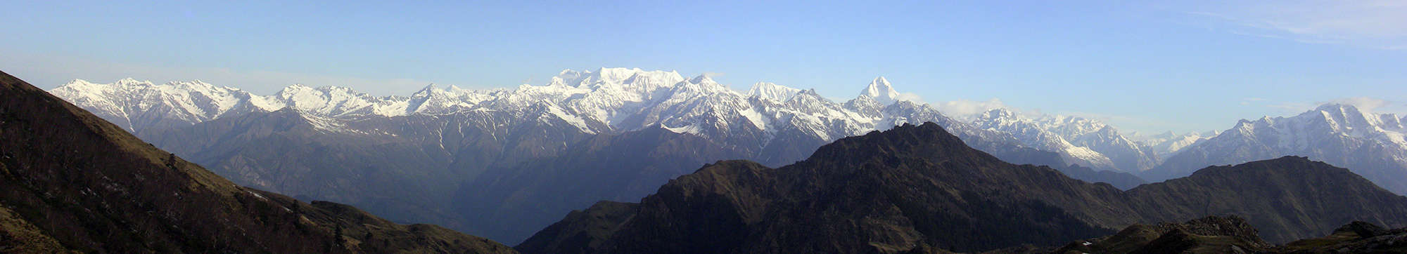
The trail traverses through forest for about 20 minutes before a steep switchbacks descent into a river gully. A new bridge is being built here so you might have a little scramble up and down banks (2592m, 30 minutes, N30º25’16.9”, E79º33’33.9”). Climb steep switchbacks for roughly 300m before the gradient eases in rhododendron forest. Wind around to another stream and bridge construction site where the trail climbs easier switchbacks to Dhakwani (aka Dhakauni, 3350m, 1 hour and 45 minutes from 1st bridge, N30º26’30.1”, E79º33’41.6”), which is a popular campsite. Switchbacks climb a stream gully beyond Dhakwani to Kuari Khal (Pass, 3718m, 1 hour, N30º26’52.3”, E79º33’59.4”), but be careful not to follow the old route in the stream bed as it gets very steep and loose. The pass is marked by large cairns and has good views, but not as good as those you'll see in another 30 minutes! The trail sightly climbs as pit traverses hillside to your northeast to a high point marked by a small cairn (3839m, 30 minutes, N30º26’42.8”, E79º34’32.0”) - this is where the panoramas begin to take shape. There is a good campsite in the shallow basin after the highpoint (3729m, 20 minutes) and just beyond is a ridge that offers some great views. Most groups descend to Tal (aka Tali, see info below), a campsite in forest near to a small lake rather than staying high but then they miss the amazing sunrise views. If you have a spare day you can walk along the narrow ridge that leads northwest from camp to Gurson Bugyal, where the views are at their best and then camp at Tal for sunset views on the Nanda Devi sanctuary peaks. The panorama includes (major peaks looking left to right): the Garwhal Himalaya starting with the massive bulk of Chaukhamba (7138m), Mandani Parbat (6193m), a distant Kedarnath (6940m), and the tooth-like Nilkanth (6596m). To the north the Alaknanda river valley marks the edge of the Nanda Devi Biosphere and the peaks of Nilgiri Parbat (6474m), Ghori Parbat (6708m), Hathi Parbat (6727m), then the dramatic spire of Dunagiri (7066m) to your east, and beyond, the summit tip of Nanda Devi (7816m).
18
Kuari Pass - Auli / Josimath 3.5hrs camp 1974m Alt Var 700m
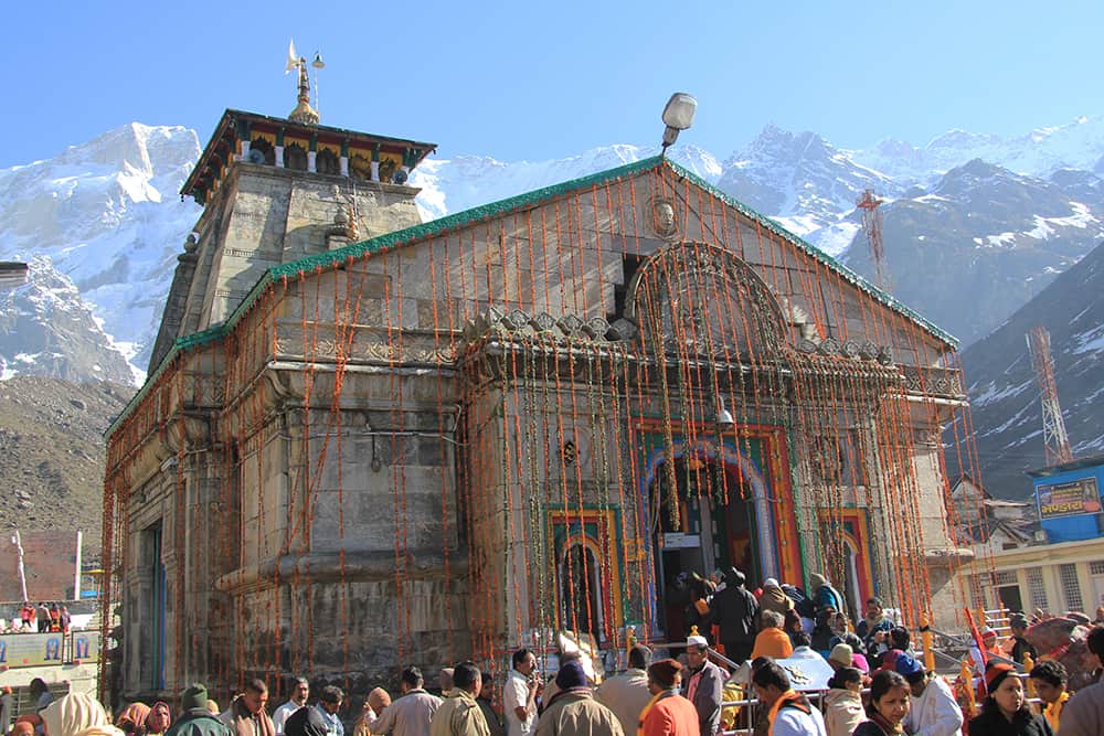
From the high point camp walk along the narrow ridge to a small Shiva shrine, do not descend on the large trail to Tapovan (aka Tapoban) if you want to enjoy views! After roughly 1 hour of walking the trail turns right off the ridge and descends into forest and in a shallow basin is a good campsite (3319m, 20 minutes, N30º28’26.0”, E79º34’21.5”). Continue through rhododendron and oak forest to the Tal campsite beside a muddy lake and the edge of open grassy hillside. The trail then climbs a little as it traverses steep hillside - note that some sections feel quite exposed. In 40 minutes you have wound around the steep section and begin crossing rolling, grassy hillside. The trail continues descending to the north and eventually enters forest near a Shiva temple (3217m, 1 hour, N30º30’53.9”, E79º33’40.8”) and an abandoned ITBP post. Then it's an easy down to the ski resort of Auli (3042m, 30 minutes) where there are some teashops and road head to Josimath (1974m, 30 minute drive). The pilgrimage site of Badrinath is a 2 hour drive from Josimath, and the picturesque village of Mana another 15 minutes beyond. After Mana you require an Inner Line Perit, this is also the route to Kalindi Khal. The Four AbodesThis is the most sacred of the 'Chota Char Dham' (Four Abodes), which include Yamnotri (source of the Yammuna river), Gangotri (source of the Ganges), Kedarnath and Badrinath. Over hundreds of years the Chota Char Dham yatra (the ‘small circuit of four abodes’ pilgrimage) has drawn countless pilgrims from across the world. Mentioned in the Mahabharata as a place where the Pandava brothers passed through on their ascent to heaven (said to be from Mana, further up the road), Badrinath has many legends attached to it. Badri refers to the berry of the Jujube tree, which is believed to have once grown here and nath means 'lord of'. The temple is dedicated to Lord Vishnu who is manifest in the Badrinarayan statue in the temple.
19
Rampur / Gaurikund / Kedarnath 5.5hrs camp 3528m Alt Var 1400m
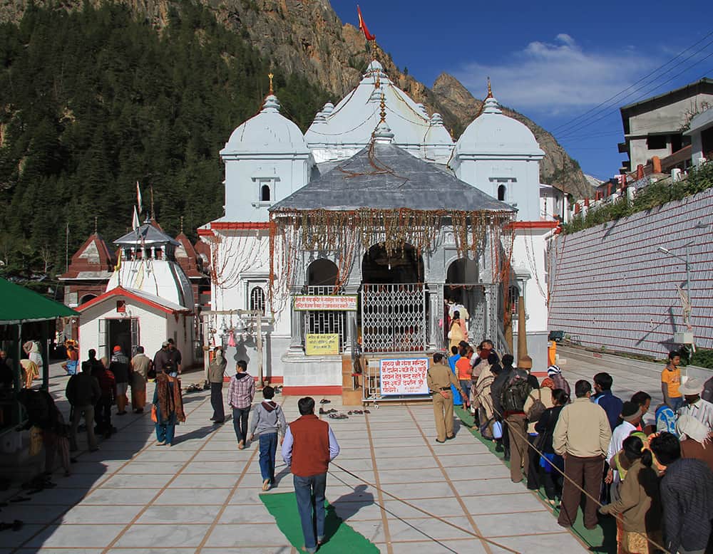
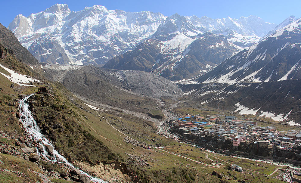
It's a 71km drive from Rudrapryag to the Gaurikund road head but most people now stop for night at Rampur, about 6km before. The hotels here are far better than anything in the noisy and congested road head. If you do stop at Rampur, make sure you get a very early start the following morning as the narrow road is jammed from 5am! Note: Rampur hotel - Hotel J.P.G. Palace, t: +91 (0)1364 262195, m: +91 (0)9412 364789, Dbl w/b Rs300 to Rs1000 Once in Gaurikund you'll have to unpack your vehicle quickly as there is no parking facility. The trail begins from the far side of the turn-around area, up some steps and into a narrow alleyway. The concrete-paved alley climbs a little as it winds between tacky souvenir shops, grotty hotels and dhabas. As you emerge from the cluster of buildings you enter the chaos of the 'horse stand'. Hundreds of mules, donkeys and horses are crammed into a small basin along with nande (basket seat carried by 1 porter) and dande (stretcher seat carried by 4 porters) carriers and haggling pilgrims. Sweepers attempt to remove the bulk of the effluent but in warm sunshine expect an olfactory overload! The prices for all pilgrim services are fixed but that doesn't prevent negotiations. Arguments abound among jostling animals so be careful as you follow the concrete trail up the true right side of the valley. Horses are tethered for at least 1km so you'll have to breath in the smell at some point! The trail is a little narrow for the amount of traffic in the lower sections so be aware of who is coming both up and down the trail. Barging is commonplace. Climb constantly on easy switchbacks with many rest stops and tea stands. In 2 hours and 30 minutes you reach Rambaran (roughly 2700m), a sprawling shanty of dhabas and rest stops that marks the half way point in distance, however, the next 7km will take a little longer due to altitude. The trail broadens from Rambaran, which makes progress a little easier. Continue climbing easy switchbacks in to an open alpine valley dominated by the massive bulk of Kedarnath peak. The Kedarnath Temple (3526m, 3 hours) and surrounding collection of hotels and dhabas lies beyond the heliport (multiple flights per days from near Rampur) but you might want to consider camping a little away from the hubbub and pick a spot up the grassy hillside (3529m) on the true right side of valley. Be careful of human excrement when you walk behind the dhabas! Kedarnath TempleThis is one of the most sacred Hindu pilgrimage sites in India and one of the 'Chota Char Dham' (Four Abodes), which include Yamnotri (source of the Yammuna river), Gangotri (source of the Ganges), Kedarnath and Badrinath. Over hundreds of years the Chota Char Dham yatra (the ‘small circuit of four abodes’ pilgrimage) has drawn countless Hindu pilgrims from across the world. Kedarnath is mentioned in the Hindu epic, the Mahabharata, whine the five Pandava brothers came here to do penance to Lord Shiva. The temple is named are a mythical King Kedar who had a Demi-God daughter. She was the partial incarnation of Lakshmi (Goddess of wealth and prosperity) and performed austerities to the Gods for 60,000 years. No wonder it's considered good luck to come here!
20
Vasuki Tal 5.25hrs camp 4240m Alt Var 1250m
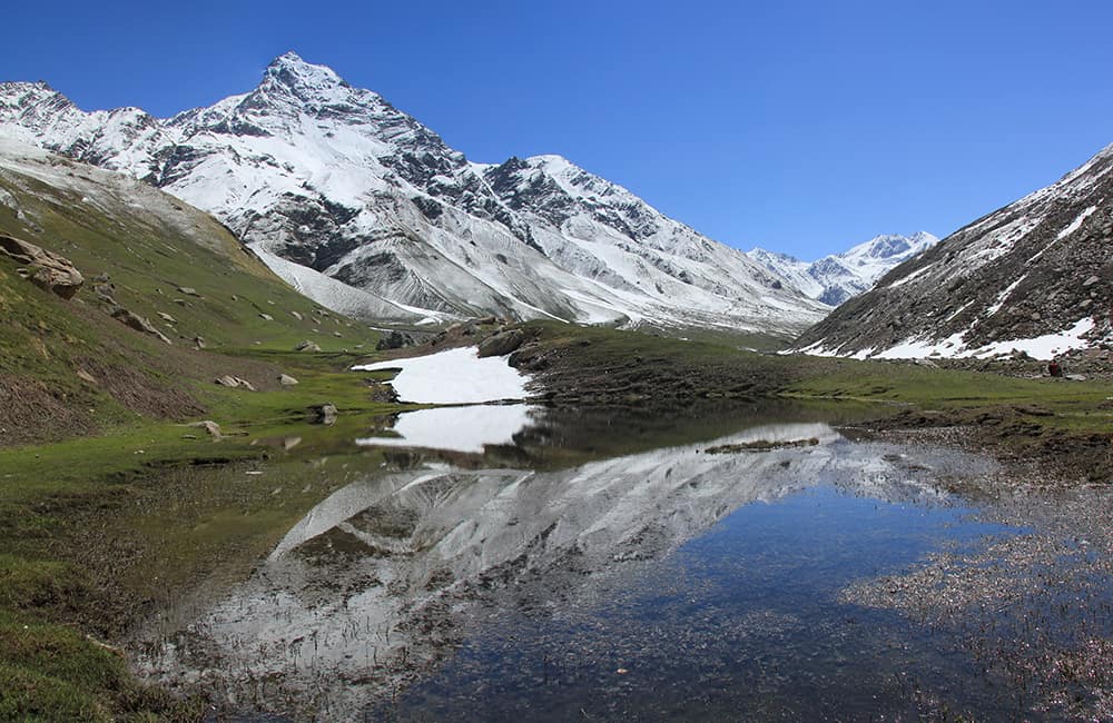
To the northwest of Kedarnath temple is small trail that switchbacks up a steep grassy hillside. Do not follow the concrete path that heads north to the glacial valley at the base of Kedarnath! In 1 hour you will reach the lip of a hanging valley (3959m, N30º 43’54.1”, E79º 03’25.3”) with good views over the temple and of Kedarnath peak. A steep spur to your west (left) climbs to a high ridge line, if there is hard snow or ice here you may want to forge a route a little further up the valley to the main ridge (it is fairly easy to cross at any low point) as the main route is exposed in places and a slip would mean a long fall. The Matialdoni ridge (roughly 4500m depending on where you cross) is 2 hours and 30 minutes from the hanging valley lip. Once in top of the ridge it is an easy descent to Vasuki Tal (4240m, 45 minutes, N30º43’29.8”, E79º02’22.0”) where there are campsites at either end of the lake.
21
Myali Pass high camp 3.5hrs camp 4700m Alt Var 460m
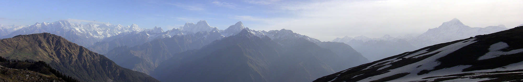
The approach to the pass follows the second tributary valley to your northwest, not the first that leads directly to the lake. It is important that you identify the right valley in clear conditions! Cross the outflow of the lake to the true right bank and then climb an easy gradient as it traverses hillside. Wind around to your right into the approach valley. Once in the valley the trail climbs up through it's centre on easy to moderate slopes to a shallow, higher basin where you can see the pass ridge above. This is an ideal camp (4700m, 3 hours and 30 minutes, N30º44’07.1”, E79º00’23.1”).
22
Myali Pass - Chauki 5.5hrs camp 3695m Alt Var 1600m
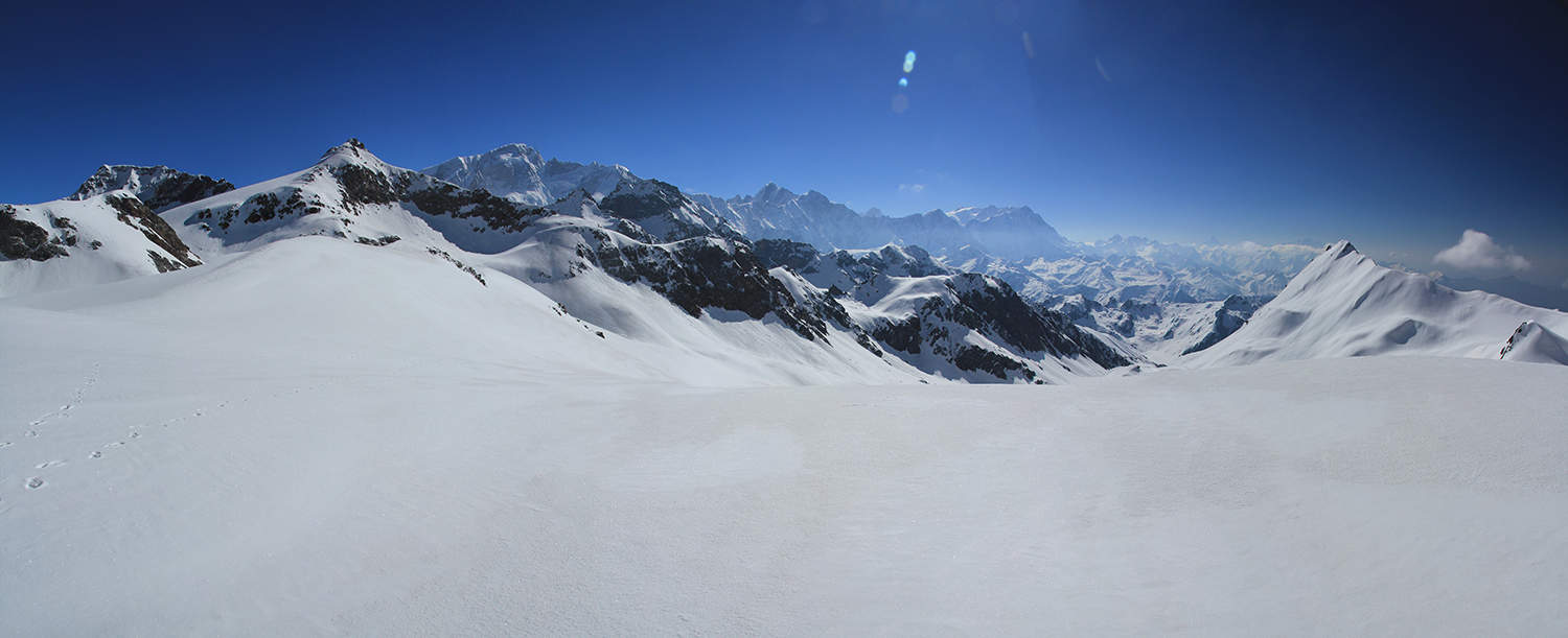
Climb to the main ridge above and then a short traverse to an obvious saddle, the Myali Pass (4981m, 1 hour and 30 minutes, N30º44’07.7”, E78º59’42.9”). Due to substantial peaks on either side of Myali, the view east is best before the pass (when you reach the main ridge) and the views west are best just after the pass. From the western side, you can spot the glaciated approach to Auden's Col, but the actual pass is not visible. The panorama to the east: the entire Kedarnath - Chaukhamba range including (left to right), Kedarnath (6940m), Kharchakund (6612m), Sumeru Parbat (6331m), a distant unnamed peak, Mandani Parbat (6193m), and the huge Chaukhamba massif (7138m). Further away is Nanda Ghunti (6309m), Nanda Kot (6861m) and the Nanda Devi (7816m) group. To the west is Jaonli (6632m) and Bhetiara ka Danda (5748m) obscure further peaks. From the pass head down into a broad flat-bottom valley, which is mostly saturated ground and shallow lake. Stay on the true left (west) bank, about 80m above the valley floor. A small trail traverses hillside and then turns left (away from the lake) to a small saddle (4805m, 1 hour and 30 minutes, N30º44’51.8”, E78º58’52.7”) on a ridge that overlooks another lake filled hanging valley. A steep descent to the end of the lower valley is followed by more steep ground with some easier sections down to the main Dudhganga valley. There is a grassy campsite about 80m above the valley floor (3695m, 2 hours and 45 minutes, N30º46’14.2”, E78º57’15.8”). Note that Chauki camp is about 30 minutes further on the far side of the valley, but it is a windy spot.
23
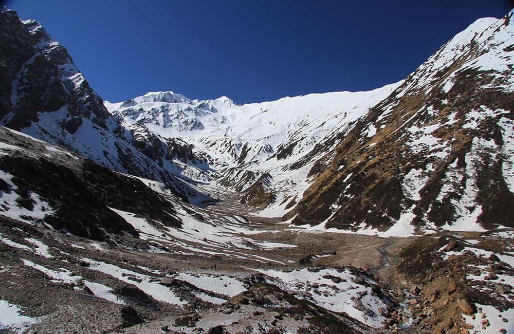
Moraine Camp 5.5hrs camp 4100m Alt Var 550m
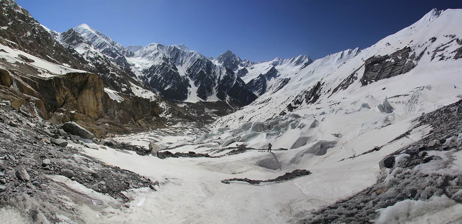
Decent to the valley floor and wade across the river to Chauki camp. An obvious trail leads up to an ancient medial moraine ahead, from the top of which (3650m, 1 hour, N30º46’47.8”, E78º57’15.5”) you can see Katling pastures below. Do not descend to them! Instead, continue along the moraine ridge for about 45 minutes when the trail drops into the Katling valley. Cross a tributary that flows down from the Phating Glacier on your right. While looking for a crossing point, make sure you stop and enjoy the impressive spire-like peaks of Phating Pithwara (6904m) that tower above. The trail then crosses the main valley and you'll need to search for a way to cross the Katling river. On the far bank (true right) the trail climbs steadily to Patargrian pasture (3715m, 2 hours, N30º48’20.3”, E78º56’59.2”), which is a popular campsite for herders in monsoon. Ahead is a cliff-lined bend in the valley, stay on the true right hillside, and just around the corner is the black snout of the lower Katling Glacier (roughly 3900m, 30 minutes). Beside the snout, on your left (true right) is a steep gully, which you climb. About half way (roughly 150m) up it is possible to climb over the edge of the gully onto steep grass and boulder-covered hillside. There are some small campsites (roughly 4085m, 1 hour and 30 minutes, N30º49’13.4”, 78º56’16.4”) on this hillside but water is scarce. You might be able to scratch out a spot, otherwise continue to the base of the first, and largest ice step (4100m, another 45 minutes).
24
Auden's High Camp 4hrs camp 4880m Alt Var 800m
Cross to a large moraine rib on the true left side of the valley but do not get close to the large cliff face beyond. Note the unstable hanging glacier above and once the sun arrives debris rains down on the unwary. Climb the rib towards some ominous-looking ice cliffs above and reach a plateau in 2 hours and 30 minutes (4506m, N30º49’44.3”, E78º55’02.9”) where it possible to camp. Remain on the right (true left) side of the glacier and climb a projecting spur of moraine that marks where the valley turns north. Once around 'the corner' come to another plateau that is crevasses but small groups can camp here (4776m, 1 hour and 15 minutes, N30º50’12.0”, E78º54’25.4”). There is another, slightly less crevassed area in 40 minutes (4880m) from where you can see the approach to the pass.
25
Auden's Col - Tal (lake) camp 5hrs camp 4778m Alt Var 1300m
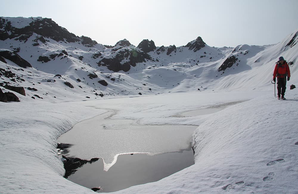
The glacier rises gradually towards the pass, which makes the going easy and gives you a chance to really enjoy the great views of surrounding peaks. Avoid the final series of ice cliffs and glaciers on the true left side of the glacier by crossing another plateau (5156m, 1 hour). Stay close to rock walls on the true left but stay far enough away to avoid rockfall and ascend to a steep-sided basin (5382m, 1 hour, N30º52’17.6, E78º53’27.0”). Ahead can be seen two rock spires on the ridge, which a popularly called the 'rabbit ears'. A steep snow sloe leads up to the right (east) side of the spires, you may need about 70m of rope as a handling for this section. The ridge just behind the spires is Auden's Col (5460m, 50 minutes, N30º52’22.0”, E78º53’31.7”). To the north of the pass the Jaonli - Sri Kanta range dominates to your left, and the Jogin group of peaks to your right. Views to the south are largely obscured by the twin spires. Descend directly down steep slopes to a broad glaciated basin , remaining on the true left side of the valley at all times. Beware of crevasses on what looks like solid open ground to your right, and rockfall from cliffs on your left. Towards the bottom of the valley remain on a moraine rib and when you can see around a large rocky spur continue to head left to a glacial lake, Tal (4778m, 2 hours, N30º54’21.5”, E78º54’05.3”), where there is a small campsite at the southern end.
26
Gangotri 6hrs camp 3042m Alt Var 1800m
An easy traversing climb ascends the moraine wall on the far side (true left) of the lake. Where the trail meets to top is marked by cairns. You then descend, cross a shallow basin and climb another moraine wall three more times to eventually arrive at a broad grassy area that would make a great campsite (4645m, 1 hour and 15 minutes) and then another beyond a small water course (4605m, 15 minutes, N30º55’25.8”, E78º53’56.6”). Wind around another couple of moraine valleys to a small grassy area and herders shelter (4515m, 1 hour, N30º56’21.6”, E78º54’04.5”). The trail now descends steep switchbacks on a grassy slope to a stream gully on your left, which you cross and then traverse to a very large sloping pasture. Descend across the pasture to another couple of potential campsites but note that there is no reliable water source for much of the year. The best of the campsites is at 4042m, before you descend to Rudugaira Gad (river), where there is a small rough campsite often used by ascending groups (3784m, 30 minutes, N30º57’41.6”, E78º54’46.9”). Remain on the true left (west) bank of the river, crossing many small landslides. You soon come to some pretty silver birch forest as the trail leaves the riverside. Below is an impressive gorge. In 1 hour and 30 minutes reach a small open area and descend a short way to a log bridge, which you cross (3331m, N30º59’08.6”, E78º55’24.2”). The trail traverses and climbs about 60m to exit the valley and then switchbacks down thru pine forest. Reach a flat area in sparse pine trees where you can see the Gangotri road across the valley in 30 minutes. The trail then traverses upstream (true left bank) through sometimes scrubby pine forest to a concreted scenic trail that soon leads to Gangotri (3042m, 30 minutes, N30º59’40.2”, E78º56’13.1”). You enter the most picturesque of the Chota Char Dham sites passing the GMVN (Garwhal government) rest house. Follow the path past the splendid waterfall and cascade at the lower end of the town and cross a couple of bridges to many guest houses and the Gangotri Temple, dedicated to the Goddess Ganga. The river here is called the Bhagiratha and only becomes the famous 'Ganga' when it joins the Alaknanda near Harsil. The trekking route to the true source of the Ganga, at Gaumukh, is 19km up valley. To limit the impact of trekkers and pilgrims, there is a limit of 150 people per day allowed beyond Gangotri. Permits are best booked in advance during the main season through a local trekking agent. Gangotri TempleThis is one of the most sacred Hindu pilgrimage sites in India and one of the 'Chota Char Dham' (Four Abodes), which include Yamnotri (source of the Yammuna river), Gangotri (source of the Ganges), Kedarnath and Badrinath. Over hundreds of years the Chota Char Dham yatra (the ‘small circuit of four abodes’ pilgrimage) has drawn countless Hindu pilgrims from across the world. The Gangotri Temple, dedicated to the Goddess Ganga, was built in the 18th century by a Nepalese General, Amar Singh Thapa, when Kumaon and Garhwal were part of the Prithvi Narayan Shah Empire. The actual source of the Ganges river is at Gaumukh, about 19 kilometres up valley – you will need to obtain a permit to go there as there is a daily limit of 150 trekkers.
27
Camp Caravan – Sian Ghad valley 1 – 2 hrs camp 2482m
From Camp Caravan walk north along the Gangotri road towards Harsil until you come to a bridge across the Bhagirathi river (1hr) although you might be able to get a lift from one of the many passing vehicles. Once over the river, head straight through the village on a concrete path, passing a small shop about half way. On the farside of the village turn left (downstream, on the true right bank) and follow and easy trail beside and a little above the river. After about 1 hour you enter the mouth of the Sian Ghad valley and there are many areas near some tall fir trees to camp (2482m, N31º02’18.2”, E78º42’59.0”). NOTE: In monsoon this valley is full of water and no camping here.
28
Jangua 3 hrs camp 3233m Alt Var 750m
Keep going upstream on the true left of the valley from the fir trees until you can see a trail climbing the hillside. NOTE: If you are in monsoon you will not have been able to walk along the valley floor, instead there is a high route winding across the steep slopes that joins this lower trail about 100m above. Climb the trail which switchbacks a little for about 250m when the gradient begins to ease. A slight descent brings you to a gully popular with shepherds (45 minutes) where you could pitch a couple of tents. From here the gradient is easy with a few minor landslide crossings to scrubby camp in 1 hour and 15 minutes. Continuing up valley, pass and do not cross, a log bridge in 40 minutes before rounding a small spur and crossing a tributary that flows down from your right. Groups sometimes camp here but there is a much better site called Jangua in a silver birch glade a bit further (15 minutes from bridge, 3233m, ref: N31°04’18.5”, E78°40’51.5”). Many wild herbs grow in the glade as well as nettles so brew up a healthy and tasty soup for lunch!
29
Gangtraro 3.25hrs camp 3760m Alt Var 430m
From the end of the glade climb grassy hillside towards a minor cliffline (can be seen from camp) about 100m above and then follow an easy traversing trail. Cross a few minor landslide areas and slowly the trail converges again with the river. Once back at the river the trail heads up a short grassy slope where I spotted a mother and cub Himalayan Brown Bear a short distance away. If you do come across bears in this valley remain completely still and silent to get the best view. Also plenty of Monal in the forest on the far bank. It is possible to camp here but the sloping gradient isn’t ideal (1 hour and 15 minutes). The trail continues on the true left bank with a few short climbs and a couple of boulder-filled gullys created by tributaries flowing down on your right. Reach the extensive pasture of Kiarkoti, 3626m (ref: N31°05’49.6”, E78°38’53.5”), in another 1 hour and 15 minutes. Beyond here the valley has patches of pasture among many boulders and small copses of twisted and knarled silver birch called Gangtraro (3760m) which starts in about 45 minutes and continues for another 30 minutes. Camp wherever you feel comfy.
30
Ratia 4.5hrs camp 4567m Alt Var 800m
The trail undulates through boulders and crossing many small streams as it heads up valley. Climb a small, old moraine to another potential camp (3972m, between 30 minutes and 1 hour depending on where you camped yesterday). From here you can see a large tributary valley to the south (on the farside if the river) that leads to the pass. Ascend across boulders to the mouth of the ‘pass valley’, crossing the Sian Ghad in 45 minutes to another potential campsite (4093m, ref: N31°06’02.1”, E78°36’22.5”). Ascend the true left of the valley on a trail that is never steep but sustains a good gradient until you reach a broad basin. The centre, level area, Ratia (4567m, ref: N31°04’29.0”, E78°35’53.8”) is reached in 2 hours and 30 minutes. NOTE: There is a high camp above here that is worth trying to get to make tomorrow shorter – continue on true left and do not descend to flat valley floor. Gradually climb rolling moraine for 1 hour (4770m, ref: N31°04’11.9”, E78°35’27.9”) to the mouth of a branch valley heading west – good camp here.
31
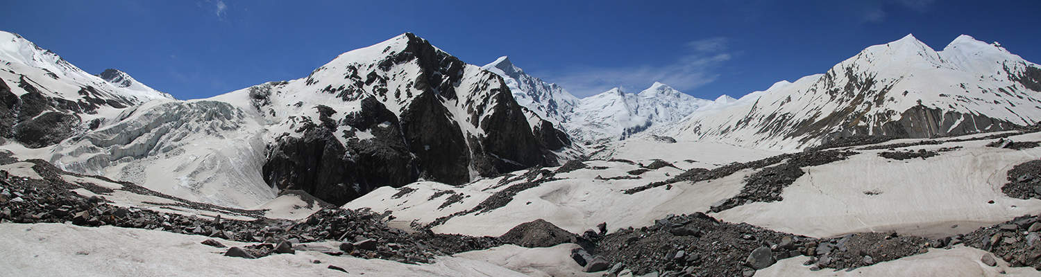
Dhumdhar Kanti – Glacier 6.75hrs camp 4940m AltVar 1150m
Head up to the higher camp from Ratia, ahead can be see the pass beside two small rocky notches on a ridge (to it’s west) and the long sloping ridge up to Black Peak (to it’s east). Coming down from the pass is a gully with loose moraine on both sides. Traverse around the base of the moraine into the gully and switchback-climb to a sloping basin at the top (2 hours and 15minutes from Ratia, roughly 5200m). To reach the pass now climb the steep slope that forms the north side of the ridge. Note that directly under the pass is near vertical so you may have to bear left (east) about 50m before traversing to the Dhumdhar Kanti (1 hour, 5313m, ref: N31°03’21.7”, E78°34’32.7”). It’s a narrow ridge on top so we quickly moved on in strong winds. On the far side we discovered hard ice beneath a couple of inches of snow, so we fixed a hand line with used prussiks and cut steps. After 60m or so of descent the snow was deep and good enough not to need the rope but then we began post-holing in avalanche debris (1 hour and 30 minutes includes rope setup, about 5150m). Do not walk out onto the glacier, instead follow the easy moraine down the true right side of the glacier and in 1 hour reach a series of shallow depressions that make good campsites (4940m). The multiple spires of Swargarhini (6252m) rise directly from the valley floor to your right (north) and Bhandarpunch (6316m) is still visible at the head of the valley.
32
Kharka 4.5hrs camp 4205m Alt Var 900m
The old trail down the true right side of the valley to some broad grassy areas is now cut by major landslide and impassable. Once nearing the glacier snout (4940m, ref: N31°03’51.4”, E78°33’39.7”) you will have to choose between descending the steep ice slopes on the glacier (beware of crevasses) or down climbing an icy and loose shist gully. Neither option is very nice and will take some time to setup and get crew thru to the lower glacier section (roughly 4500m, 2 hours or more). The lower glacier is benign in comparison and it is an easy march down the centre to flat-ish moraine beyond. On the true right is a steep moraine wall which you need to climb (about 150m and be careful!) at some point. Above the wall is a long grassy ablation valley and many camping options, we stopped at 4205m, 2 hours and 30 minutes (ref: N31°04’30.8”, E78°30’49.4”) from snout.
33
Seema 6.5hrs camp 2855m Alt Var 1540m
Continue down the ablation valley to where a steep hillside cuts across (roughly 3950m, 45 minutes), which you then climb. The trail is sometimes scrambling beneath rocky bluffs to a high point, 4025m (30 minutes, ref: N31°04’18.7”, E78°29’14.4”) before descending grassy slopes that eventually lead to Ruinsara Tal (more a pond than a lake) and two small, dirty and heavily graffitied huts (3626m, 1 hour, ref: N31°04’54.1”, E78°27’20.0”). Enter silver birch forest and cross some strong flowing streams that flow down from gullies on your true right. Continue down stream always on the true right of the valley and crossing many minor streams as well as ducking through one that pours on your head! A pilgrims rest shelter looks out of place at 3088m (2 hours and 15 minutes) and in another 30 minutes reach a new bridge (2948m) over the main river. Cross and climb through mixed forest to a wildflower meadow (3039m, 15 minutes) where Indian tourist groups like to camp. Between here and Seema (2 hour and 30 minutes away) are a few good campsites, but most groups continue to Seema where there is a Garhwal Mandal Vikas Nigam (GMVN, see
www.gmvnl.com for details) and some small shops.
34
Sankri 6hrs + 1hr drive camp
The trail undulated along the true left (south) bank of the Tons valley all the way to Sankri, mainly through mixed forest and open cultivation. In 1 hour and 30 minutes pass the campsite at Gangar (2355m, N31°06’21.67”, E78°18’50.52”), where the picturesque village is on the far bank. Another 2 hours and 30 minutes brings you to Beda camp (2053m, N31°05’10.15”, E78°16’05.0”) where Datmir village is a few hundred metres above.
NOTE: trails from Datmir head south (to Baradsar) and southeast (to Yamnotri) The final 1 hour of trekking brings you to the roadhead at Taluka (2110m, N31°04’42.45”, E78°14’44.98”) where there are a few shops and a GMVN rest house. A regular jeep service plies the route to Sankri (1 hour drive, 1940m, N31°04’40.87”, E78°11’03.44”) where there is are some shops, a couple of dhabas, a meat shop and a convenient barber's shop if you’ve been on the trail for a while! There is also a GMVN resthouse and the Swargarohini Guest House run by Chain Singh Rawat who also runs Harkidun Protection and Mountaineering and Mountaineering Association (
www.harkidun.com). From Sankri it is a 45 minute drive to Naitwar and the Govind National Park office.