GHT Nepal Treks
The Nepal Himalaya is an amazing place. Somewhere you can immerse yourself in authentic cultures and be inspired by the greatest mountain scenery on the planet. GHT Nepal Treks offers you the chance to explore unhindered trails at your own pace.
The three main trekking regions, Everest, Annapurna and Langtang, attract tens of thousands of trekkers every year. Facilities have never been better and easily rival those found in Europe or elsewhere. There are even some luxury lodges in the Everest and Annapurna should you want a touch of comfort! Trails are well maintained and safe, and the locals will welcome you with genuine friendliness that will make your heart melt.
The other two-thirds of Nepal’s mountain terrain is normally considered ‘off-the-beaten-track’ and counts visitors in mere hundreds. From the lush rhododendron forests of the east to the dense woodlands in the west, the Nepal Himalaya is predominantly wilderness dotted with remote communities. In these regions, a small trekking group can make a real difference to lives that are barely subsistence.


Although the mountains are beyond compare, it is the people you meet along the trail that linger in your memory.

You can’t help but admire their indefatigable boldness and energy, their independence, strength and resilience, and their fun, openhearted, generous nature towards strangers who may never return. It’s impossible to make a comparison, but surely the people of the high himalaya are the very best of mankind?
For many years, one of the great trekking ‘holy grails’ is the route through the remotest peaks of the entire Himalaya, the Great Himalaya Trail. The GHT Nepal High Route can take 90 to 150 days of walking, so for convenience it is broken into sections. Each section has easy access and lower route alternatives through the pahar (mid-hills).
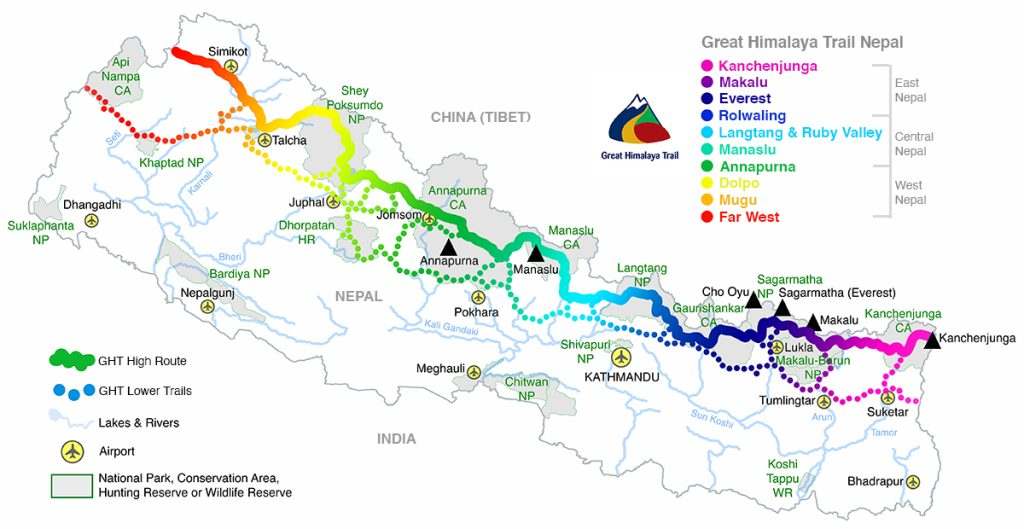
GHT NEPAL ROUTE MAP
The Great Himalaya Trail is a personal challenge along a trail system that allows you to develop your own route priorities and set your own goals
The Great Himalaya Trail is a personal challenge along a trail system that allows you to develop your own route priorities and set your own goals. Treks can be as short as just 5 or 6 days at low elevation through to extreme journeys of months at high altitude.
For some, the ultimate Great Himalaya Trail challenge follows a trail network that links the ‘highest feasible route’ along the length of the various himals – the GHT Nepal High Route. However, weather and time restrictions mean that trekkers often choose sections that by-pass technical passes or navigation problem areas. So, linking lower village-to-village trails with higher routes has become the accepted norm when designing itineraries. The GHT has become a way to immerse yourself in Himalayan cultures and challenge your boundaries – there truly is a trail for everyone!
GHT Nepal Popular Treks Comparison
|
|
Nepal High Route | GHT Challenge | GHT Low Route* | East Nepal | Central Nepal | West Nepal |
| # of days |
120 |
45 | 90 | 50 | 44 |
40 |
| Ave daily distance |
15km |
41km | 18km | 15km | 15km |
15km |
| Highest point |
6190m |
6190m | 5419m | 6190m | 5415m |
5563m |
| Can you go solo? |
About 50% |
Yes** | Yes*** | About 65% | About 75% |
No |
|
Best season |
Mar-Jul | Oct-Nov | Oct-Apr | Oct-Nov | Oct-Nov |
Mar-Jul |
* the low route is constantly changing due to extensive road building across Nepal
** the GHT Challenge accepts individual entries
*** solo trekking is route dependent and not possible in some areas
GHT Nepal Route Options
The Great Himalaya Range stretches 2400km, forming a natural barrier between India and China, with Nepal covering the central third (865km). The eastern third of the Nepali GHT includes the highest mountains in the world and connects Kanchenjunga with Makalu, Solu-Khumbu (Everest) and Rolwaling regions. A central section joins Rolwaling to the Langtang valley, then on through the Ganesh Himal before ending in Manaslu. The western section links the Annapurnas to Mustang, Dolpo, Mugu and ends on the banks of the Mahakali Nadi or in the north-west region of Humla.
For many, Kanchenjunga Base Camp is the beginning of their GHT

GHT East Nepal – Kanchenjunga to the Last Resort
- Higher Trails – In the far northeast corner of Nepal is the Jhinsang La, an extremely remote and dangerous pass on the north side of Kanchenjunga. So, the accepted start of the GHT Nepal High Route is the nearby Kanchenjunga Base Camp. The trail heads down to Ghunsa, and then westwards over the Nango La to Olangchun Gola. Head northwest up and over the remote Lumbha Sambha, down through Thudam and along the Arun Nadi to Hongon. Climb back to the Tibetan border towards Popti La, and then head west before the pass to the Saldim Khola and over to the Barun Nadi. Pass through Makalu Base Camp and over the Sherpani Col, West Col and Amphu Labsta to the Solu-Khumbu (Everest region), where you cross the Cho La and the Renjo La to Thame. Cross the Tashi Labsta and descend through the Rolwaling to the Last Resort.
- Lower Trails – From the Singalilla National Park viewpoint of Phalut, head cross-country to Taplejung and then over the Milke Danda following an ancient trade route to Khadbari. Then choose from some fantastic community and wilderness trails that cross the Makalu Barun Buffer Zone towards the upper and lower Solu-Khumbu.
View from Chogormogor Kharka of Dorje and Kangja Himals and a distant Gosainkund

GHT Central Nepal – The Last Resort to Kagbeni
- Higher Trails – From the Last Resort, climb to Chogormogor Kharka, near to Bhairav Kund. Then cross the Balephi Khola and climb to Panch Pokhari before crossing some tricky navigation to Tilman Pass and on to the Langtang valley before descending to Sybru Besi. There are alternative routes to Syabru Besi via the Kangja La or Laurabina La, both of which are reached by trekking through Helambu. From Syabru Besi, continue to Gatlang and then across the Ganesh Himal foothills to the Manaslu Circuit. Continue around to Dharapani via the Larkye La, and then around the Annapurna Circuit to Kagbeni via the Thorong La or Tilicho Lake.
- Lower Trails – There are dozens of intriguing cultural trails throughout the lower Solu Khumbu that will either lead you to Jiri or directly to Kathmandu. From Jiri, head north and visit the lower Rolwaling, especially Bigu Gompa, before heading across to the sites of Helambu. Panch Pokhari and/or Gosainkund are worth including as part of a cultural route to the Ganesh Himal, and then to the ancient capital of Gorkha and the comforts of Pokhara.
The Kagbeni Valley with Thorong La visible on the distant ridge line to the left

GHT West Nepal – Kagbeni to Hilsa or Darchula
- Higher Trails – From Kagbeni head northwest into Upper Dolpo via Chharka Bhot and then pick one of two routes; westwards to Dho Tarap and Ringmo and then north to Pho, or, head northwest from Chharka Bhot to Shimengaon and then head west to Pho. From Pho there are two routes to the Mugu Karnali Nadi valley and both descend to Gamgadhi. After visiting Rara Lake, a trans-Himalayan route along the Karnali corridor brings you to Simikot and the last section of trail up to the border post at Hilsa.
- Lower Trails – From Pokhara, cross the Dhorpatan Hunting Reserve to Dunai and follow an ancient trade route through Lower Dolpo to Jumla and Rara Lake. An extensive network of trails heads west connecting some of the least visited regions of the entire Himalaya and all are worth the effort to explore! Eventually you arrive at Darchula on the banks of the Mahakali Nadi and the border with India.
The most Westerly of Nepal’s Himals – Api and Saipal

Please Trek Responsibly
The GHT actively researches new trekking routes and updates current trail information for trekkers. Through the introduction of new trekking routes in remote communities we encourage locals to develop micro-tourism businesses in places that are too remote for intensive infrastructure development. By creating value in regions that previously had little to offer for tourism, it is hoped that the relevant government departments will further expand the network of National Parks and Conservation Areas to form a continuous corridor for animal migration, which could reduce illegal hunting and help save many endangered species.
The Impact of Your Trek in Nepal
Nepal is a poor country, so the money you spend in the country is vital to livelihoods and economic prosperity. But where and how you spend the money is just as important as the amount you spend.
Paying locals directly for produce and services rather than going through guides or middle-men avoids the chance of commissions and excessive negotiation, which will reduce the amount paid. Paying direct also gives you the ‘right of choice’ for what you are paying for, which gives you a chance to promote more sustainable practices.
Unfortunately, responsible tourism isn’t a high priority among Nepali guides and trekking companies, who often prefer the cheapest option or an imported product, rather than the most sustainable. For example, when selecting things to eat, you might prefer the freshest vegetables that have been grown locally, rather than those bought in from afar. Or, if you have to purchase some clothing for your trek, locally made in Kathmandu can be just as good as products imported from overseas.
You will see that for each trek, we calculate the social and environmental impacts of GHT Treks – and also consider the Trade Off between impacts.
The Trade Off
Here are some typical decisions trekkers need to address that involve trade-offs:
- How much support do you need? – Independent GHT Treks mean carrying between 16kg and 25kg per person throughout the whole trek. Whereas, Supported GHT Treks mean that you carry less than 8kg all the time.
- Health and Safety? How much Nepali do you speak? Are you skilled in mountain first aid?
- Navigation and Skills? Have you already trekked some of the trails? How good are you at navigation in remote wilderness areas? Do you have technical mountaineering skills to set abseils, cross glaciers, etc.
For a thorough review of all the research and planning issues you need to address, see the GHT Guide Book – Nepal Trekking and the Great Himalaya Trail.
See the Impact of Your Trek page for more information about impacts and how to manage them.
The snow-covered crown of Asia may then become one of its greatest assets, so please walk softly, leave only smiles and take only happiness.
Planning & Logistics on the GHT Nepal Treks
The remote sections of the GHT require full camping equipment, but for many of the trails in the main trekking areas or lower routes it is possible to rely on teahouses or local lodges for accommodation. Logistical issues, fitness and weather all combine to make trekking long sections a major challenge for even the most experienced and well-equipped hikers.
For some remote sections, campsites and trails are very hard to locate, requiring local guides to help you find your way. For any route in Nepal, it is advisable to purchase large-scale topographic maps to assist route-finding; a GPS and a satellite phone are handy too. Groups should carry the minimum possible and rely on the least number of tents (ideally not more than ten), as most places to camp are very small. Villages will probably not be able to sell you much food, so expect to be self-sufficient for most of the time.
The highest routes involve crossing many high passes, some requiring ropes and climbing equipment, so groups should have alpine climbing and rescue experience. Plans and contingencies for emergencies should be taken seriously; rescue from many areas along the trail could be very difficult. However, the experience of exploring remote regions, meeting the challenges of route-finding, crossing passes, and sharing in the life of communities who are always surprised and pleased to see you, is simply amazing. There is no ‘tourist trail’ that can duplicate the joy and sense of achievement of the Great Himalaya Trail.
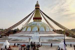
While in Kathmandu, walk around Boudha three times (a kora) for good luck before beginning your trek
Warning
All outdoor activities involve an element of risk, which could endanger you and those with you. It is impossible for any guide to alert you to every possible danger or hazard, or to anticipate the limitations of your party. The descriptions of trails, passes, routes, geographical features on this website are therefore not in any way a guarantee that they will be safe for you or your party. When you follow the advice and/or route information on this website you do so at your own risk and assume responsibility for your own safety.
Ensuring that you are aware of all relevant factors and exercising good field-craft combined with common sense is the best way to enjoy the mountains. If you feel unsure about your skill level, experience or knowledge base then you should not assume responsibility for yourself or a party.
The political situation in Nepal will change and could affect your plans. It is wise to keep abreast of all developments and check government and relevant agency websites for your own safety. You assume the risk of your travels and the responsibility for those with you. Be safe, be prepared, be informed.
Tsarang in Mustang is not on the direct GHT Nepal High Route but is worth the side trip

