1
Day 11 Tangbe to Chochomey, 4.25hrs, 550m
The roadhead for the next section of trail (Snowman Trek) is Menchugaon, a scruffy place where road-workers live. If you walk from Tangbe it will take 2.5hrs, or it’s a 30 minute drive.
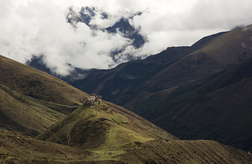
Cross the bridge beyond the roadhead and follow riverside trails on the west (left) bank. Do not follow the new road to Dur village. The trail passes through some pleasant grassy areas, which used to be used as campsites before the road was extended to Menchugaon. If you walk from Tangbe, this could be a good place to stop if you require time for resupplies to arrive. After walking for 1 hour and 30 minutes (roughly 2800m) the trail begins a switchback climb to Ghoresum (3100m, 1 hour), which is another campsite. The gradient eases but the trail becomes muddier and muddier from here as you climb through bamboo forest to Chochomey (3245m, 1 hour and 45 minutes) where there is a simple herder’s shelter.
2
Day 12 Chochomey to Kurpang, 6hrs, 700m
Yesterday’s trail will give you a good idea of how much mud there might be today, and certainly expect conditions to be much worse. If locals have been taking their animals up to the high pastures then this will make things even muddier. If the trail is in good condition then you will be able to continue through to Tshochenchen and extend the amount of time you can spend at the hot springs!
From Chochomey the trail heads into dense forest as it gradually descends to a bridge over the Dur Chu (3080m, 1 to 3hrs depending on trail condition) where you then climb the east (right) side of the valley to a large grassy area (3245m, 1 hour) before passing through a short forest section and coming to an even larger grassy area in 15 minutes. A brief pretty forested section gives way to a very muddy trail as you climb steep hillside, which also has some loose landslides. In 2 hours and 30 minutes you come to Kurpang (3568m), a grassy riverside campsite that’s popular with herders. If the trail has been tough going you may want to rest here.
3
Day 13 Kurpang to Djule Tsho, 6.75hrs, 1260m
The trail heads through some fine rhododendron and pine forest which although has some muddy sections is generally a joy to walk on. In 1 hour and 40 minutes reach a bridge (3916m) over a tributary of the Dur Chu. After crossing the bridge there is a short section of switchbacks before the gradient eases in dense rhododendron forest and you enter a pretty alpine valley. A few herder’s huts in the far side of the valley and a trail-side campsite are called Tshochenchen (3954m, 30 minutes from bridge) and is a popular campsite for those lucky enough to have had no mud!!
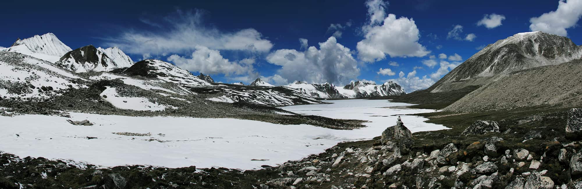
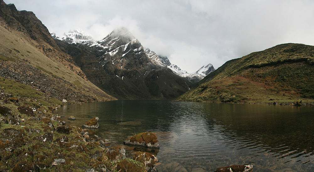
Continue up the valley on the east (right) bank of the now infant Dur Chu. In 30 minutes the valley turns west (left) at about 4080m and the trail starts to climb the north (right) hillside to a small tributary valley. It takes about 1 hour and 30 minutes to complete the climb to a herder’s hut, which has some large stone slabs as a windbreak (4373m). Ahead there are two waterfalls. The left hand waterfall cascades over dark rocks and it is these that you now climb to first pass Animo Tsho (4540m) and then on to the Djule La (4685m, 1 hour and 20 minutes from hut). The trail is a little steep and rocky towards the pass, which is marked by cairns, chorten and prayer flags. From the top of the pass you can see the large Djule Tsho below, to get there descend northwesterly to a small flat area (30 minutes) where a melt-water streambed forms the trail down to the main valley. There is a herder’s hut and campsite (20 minutes) on the eastern side of the lake but if you have time continue around the northern bank of the lake to a herder’s hut at the very western end of the lake (4339m, 30 minutes) where there are views of the Mangdu Chu valley and reflections of craggy peaks in the lake.
4
Day 14 Djule Tsho to Dur Tshachu, 3hrs, 1100m
A trail climbs north-northwest from the herder’s hut around a couple of spurs and then to the Kutong La (aka Gongto La, 4391m, 30 minutes). A steep switchback descent across open hillside brings you to another herder’s hut in a small valley (4177m, 30 minutes) and back to the treeline. Some sections of trail now traverse through pine, birch and rhododendron forest but it is pretty well all down to the hot springs at Dur Tsachu (3393m, 2 hours).
All of the spring waters are collected in wood-lined ‘tubs’, the hottest ones becoming heavily calcified. The highest springs are the hottest at 52.3C, the middle section of tubs are around 42-43C (some have a green algae that needs to be cleaned out) and those beside the Mangdu Chu are around 38-40C. A long soak while watching clouds in an azure sky float by overhead, the swaying pine trees and numerous birds flitting back and forth is just about the best possible reward for making the effort to get here. Each pool has specific therapeutic properties, except for the hottest pools, which are said to be good for all round health. Lie back and enjoy a sense of tranquility that only Bhutan can offer!
5
Day 15 Dur Tsachu to Warthang, 5.75hrs, 1300m
The trail heads upstream on the east (right) bank of the Mangdu Chu for 30 minutes to a bridge, which if it hasn’t been recently repaired (post-monsoon 2010) then your horse driver may refuse to take his animals across. We unpacked the horses and took them across one by one. The bridge is not very stable and when it swings or bounces the horses get spooked, some of the wooden planks are rotten as well. Once on the west (left) bank the trail climbs a little through forest before coming to what looks like a landslide or small GLOF (Glacial Lake Outburst Flow). Beyond is a herder’s hut and potential campsite (3475m, 45 minutes) but this is not the trekking route. The trail has been damaged by whatever has caused the damage to the stream before the camp. Climb the rocky debris for about 100m and you’ll find the trail to the north (right) side of the stream. It’s now a long switchback climb to clear the treeline and then across some shallow alpine valleys to the Nephu La (aka Napthang La, 4603m, 4 hours). A large alpine valley is on the far side of the pass where there are a few herder’s huts. Camp beside one which is unused (there are frequently locals here) and you’ll probably find that this is where you change your horses for yaks. The entire valley is called Warthang (aka Uruthang, 4534m, 30 minutes from pass).
6
Day 16 Warthang to Minchugang, 5.5hrs, 1400m
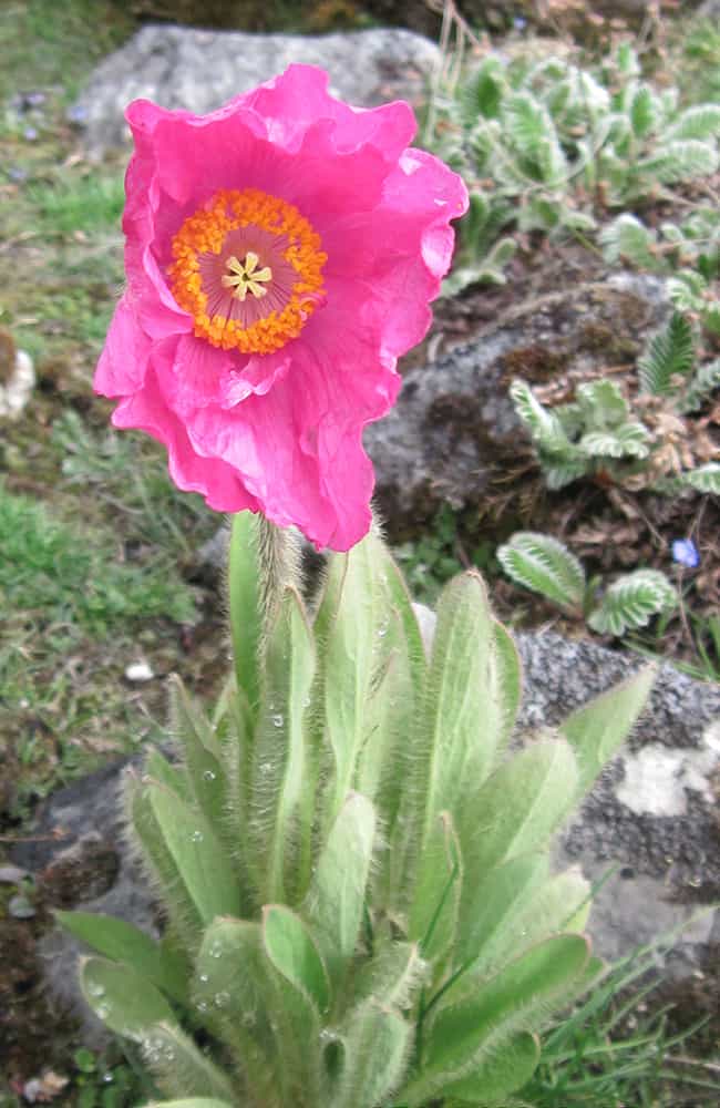
Passing a large rocky mound in the centre of the Warthang valley head north following a watercourse to what looks like a dead-end (30 minutes). A stream cascades down rocks to your north-northwest and the trail climbs to the right of it, steeply at first, but once on top of the rock section the gradient eases to the Warthang La (4779m, 1 hour). Traverse above a small lake before descending to another slightly larger lake (4728m, 15 minutes) – do not descend any further! Instead, head northwest over grassy mounds passing a herder’s hut before beginning to climb again. The gradient quickly becomes steep as you climb grassy slopes, which become muddy switchbacks and then a rocky trail as you reach the Sake La (aka Saga La, 4982m, 1 hour and 15 minutes). Care should be taken on the steep descent as ice often underlies loose earth making for some skiddy sections. In 30 minutes reach the side of a pretty turquoise lake where the trail becomes sandy on a gradual descent to herder’s huts at roughly 4700m in another 20 minutes. Then climb to a ridge with chorten and some prayer flags called the Bragdi La (4751m, 30 minutes from lake) where you look down into the large Gangkar Pheunsum Chu (aka Sasha Chu) valley. A large, steep grassy hillside lies beneath your feet and there are a number of routes to choose from. Probably the easiest is to traverse right above the grassy slope towards a craggy ridge before which you descend steeply. Alternatively, cut diagonally across the hillside heading down to the bottom of the craggy ridge, but this route involves following animal trails and threading through dwarf rhododendron at times. Do not descend to the river! On either route you will come across a trail that heads across the bottom of the slope about 100m above the valley bottom. Follow this trail up valley heading northwest (right) and in 1 hour and 20 minutes descend slightly to a grassy area next to the river called Minchugang (4294m). From mid-May you might be lucky and find blue, pink and yellow poppies near the camp.
7
Day 17 Minchugang to Zanum, 5.5hrs, 750m
Today offers some wonderful trekking as you gradually climb towards Bhutan’s highest peak at the end of a spectacular alpine valley. If you are here in late spring or the summer months the valley is a carpet of flowers, including the rare blue, pink and yellow poppy.
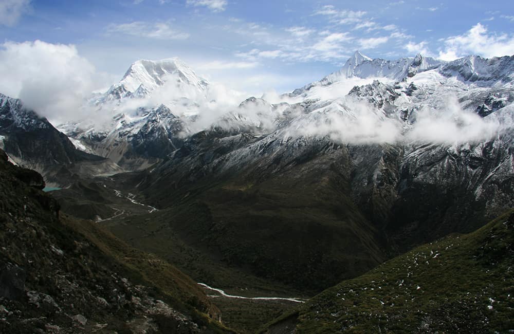
The trail remains on the east (right) bank of the river as you ascend what feel like giant terraces from one section of alpine U-shaped valley to another. The lower broad valley areas both are called Gechey, the first is Gechey Woma (4477m, 1 hour and 30 minutes), which continues for another 50 minutes to some more herders huts (4613m) before the trail climbs again. The second, in another 1 hour, is Gechey Koma (roughly 4740m) where the herder’s build temporary shelters when moving yaks up and down the valleys. From here large hills of ancient moraine narrow the valley before the last broad valley section, Zanum (5046m, 2 hours) where you can camp at the base of the branch valley that leads to tomorrows pass. This section of valley is worth exploring a little as there are plenty of mountain views to enjoy. At the head of the valley is the Gangkar Pheunsum massif (7541m).
The Bhutanese don’t have a strong tradition of naming peaks so one name often refers to a number of mountains within a range. Certainly the spire-like peaks that form the north end of the Gangkar Pheunsum range are stunning in the afternoon light.
8
Day 18 Zanum to Tshorim, 4.5hrs, 570m
From the main Zanum valley walk into a smaller side valley surrounded by moraine, which heads west. There are a number of routes into the valley, but there is a ‘main trail’ that stays on the southern (left) moraine hillside. Gradually climb to the top of the moraine to your south (left) where you can see a chain of craggy peaks to the south and between them and you is a glacial lake (roughly 45 minutes from camp). At first it seems like you are heading for a long flat ridge to your northwest (right) but this is not the case. Behind you are some great views of Gangkar Pheunsum. Continue climbing up and down a long moraine ridge heading west while keeping well above the glacial lakes (a second soon comes into view) to your south. After 1 hour and 20 minutes the trail enters a narrow ablation valley, which you climb to the end and then you get the first view of the cairns and chorten on the pass ahead. However, to get there you have to cross a shallow valley with another two glacial lakes. A scrambly trail heads around the northern (right) bank of the larger lake, the animal route crosses a narrow piece of moraine that separates the two lakes before a slight climb to the Gohpu La (5466m, 45 minutes). The pass is broad with numerous cairns, chorten, prayer flags and some walls that act as windbreaks that are welcome as you relax and enjoy some great views! The pass is highly decorated as it marks the Bumthang-Lunana district boundary.
The descent from the pass is on an easy trail that passes a couple of small lakes, you should stay on the north (right) side of the valley. In 1 hour you come to Tshorim (5344m), which means ‘long water’ where there is a campsite. If you continue to the end of the lake and second a little more there is a much more sheltered spot to camp, also referred to as Tshorim (5315m, 50 minutes).
9
Day 19 Tshorim to Thanza, 5hrs, 1200m
The mountain views around you and along the trail are great today!
Stay on the northern (right) side of the Tshorim lake outflow as you descend an easy trail over rolling moraine to a broad valley called Sumji (4853m, 2 hours and 15 minutes). From here you ‘step’ down to different campsite options the most popular of which is Dangey (4674m, 40 minutes). Near Dangey is a log bridge, which leads to the Nicochu La, Tsho Chena and the route of the ‘Half-Snowman Trek’. The trail quickly descends to the river, which it follows for roughly 45 minutes (4477m) to a point that you start to climb hillside. It’s not much of a climb before you start traversing but the river falls away rapidly in a series of waterfalls so it at first looks higher. In roughly 40 minutes come to a ridge that sticks out a bit further than the others and offers good views up and down the valley, especially of Thanza and Table Mountain, now renamed after the 4th King Gangkar Sinjey. The extensive damage caused by the 1994 GLOF are also evident. There are a number of places to camp in the valley bottom; the first and most popular is near the Flood Warning Centre in the new village of Thanchor (aka Thenchey, 4147m, 30 minutes). Or you can head 20 minutes up-valley to Thanza, which could possibly be the highest permanent settlement on earth (4165m).
10
Day 20 Thanza to Lhedi, 3.75 – 4.75hrs, 400m
You have another trail choice today, either via the village of Cheoza or a direct trail. Take the old trail on the west (right) side of the Phu Chu valley to reach the village of Cheoza (2 hours and 30 minutes from Thanza), which has an old fortified gompa that the locals call a dzong in the centre of the village. I walked this route in a fierce snowstorm so I didn’t explore. Instead I took the direct route down the east (left) side of the flat valley below Thanchor to a bridge (4000m, 1 hour and 30 minutes) that crosses to the main trail beneath Cheoza. You then stay in the rough valley carved by the river – beware of rockfall! In 30 minutes you emerge into another broad valley that has also been scoured both by the 1994 GLOF and the monsoon floods of 2009. The devastation to what once a beautiful forested valley shows the merciless power of nature and climate change. Reach Lhedi (3728m, 2 hours and 15 minutes) where you can camp in the school grounds. Massive boulders seem to hang precipitously on the steep hillside above the village while the Phu Chu is constantly trying to wear away the remaining grazing and farming land; a more precarious existence is hard to imagine.
11
Day 21 Lhedi to Wochey, 5.75hrs, 1570m
From the end of Lhedi descend to the broad sandy and rocky riverbed, which you walk along for 50 minutes to a where a river cascades down into the valley. Some grinding mills make use of the torrent that you cross via a small cantilever bridge (3661m). Continue passing through a hamlet along a trail that gradually climbs for about 30 minutes and then the gradient increases to Dengar (aka Tega, 3945m, 1 hour and 45 minutes from cascade). From above the 8 or 9 homes in Dengar there is a viewpoint of the Thanza valley and Table Mountain, which provides a chance to rest and figure out which of the three trails ahead you should take. The trail that heads southwest goes to Punakha, to the west is a large track that leads to village grazing areas, so the one you want heads northwest towards a craggy hill. Climb easy switchbacks through rhododendron forest to a small alpine valley where a hermit from Dangey has taken up residence and may be chanting by the trail. The trail gets steep as you now climb to the Kechey La (4661m, 2 hours from village) and then descend past two lakes into the Wochey valley. As you pass the second lake you can see the village at the valley mouth, which gives the valley its name. There are campsites on either side of the river in the valley bottom (4156m, 1 hour and 15 minutes).
12
Day 22 Wochey to Tarina, 5.75hrs, 1000m
Begin by crossing to the north (right) bank of the Wochey Chu and heading downstream on a good trail through some lovely pine and rhododendron forest draped in Spanish Moss. In 1 hour reach Wochey village (3911m), a collection of maybe a dozen homes. Just beyond the village is a trail junction where you must turn north (right) – do not descend on the left fork. The trail then climbs very briefly as it rounds the final spur out of the valley and then you have a long steep and muddy descent to the Tarina Chu (3642m, 45 minutes). Follow an easy trail on the east (right) bank through forest, across landslide debris and the occasional grassy area, the largest of which has lots of rubbish left by locals (3883m, 1 hour and 40 minutes). Just beyond is a bridge over the Tarina Chu and for the remainder of the day you follow the west (left) bank of the river.
In about 1 hour come to another smaller grassy area before heading across alluvial or landslide debris spread across the bottom of the valley. In another 1 hour and 15 minutes the trail comes to dwarf and scrub rhododendron with some grassy areas, which is called Tarina camp (4099m).
13
Day 23 Tarina to Narithang, 6.25hrs, 1400m
Climb through rhododendron forest on a sometimes rocky trail. The gradient increases as you ascend switchbacks and a good rest stop is a large rock after 1 hour, which offers views of surrounding peaks and the valley below (roughly 230m of ascent). The trail then begins traversing southwest into a high tributary valley that is far too steep to access directly from the campsite. Climb up through this valley and then more switchbacks to the high moraine-covered plateau (4968m, 2 hours and 30 minutes from camp) that eventually leads to the pass. Trek past a small lake to your south (left) as you ascend moraine and shallow ablation valleys to a bowl-shaped valley beneath the Karakachu La (5215m, 1 hour and 45 minutes), which is a narrow ridge covered in prayer flags and cairns. The western side of the pass is broadly called Narithang and is a series of shallow grass-covered valleys surrounded by moraine. Long ago this must have been a heavily glaciated region but now there is only one small glacier flowing down from some craggy mountains to your south. There are plenty of campsites to choose from it just depends on how long you want to walk. There is a nice sheltered spot after 1 hour (4911m) that I’m told is popular with groups but not herders, which is why there isn’t much animal dung.
14
Day 24 Narithang to Rodophu, 4.75hrs, 700m
The trail heads west across shallow valleys and rolling moraine. About 1 hour from camp you cross a saddle on a moraine ridge marked with a cairn (4907m) before descending into a large shallow valley. Keep heading west to another moraine ridge with chorten and cairns called the Ladam La (4906m, 1 hour). There is a descent of roughly 50m from this pass into a slightly deeper valley which you cross to a ridge and the Tshumo La (4878m, 30 minutes), which has two large decorated cairns that mark the Laya-Lunana boundary. Around the base of the cairns were fresh snow leopard tracks only a couple of hours old!
A short descent leads to a shallow basin from where the trail continues down a rough and loose steep trail for roughly 100m to a large valley. Walk to the rim of the valley and follow the route of a stream that cascades about 400m to a flat-bottomed alpine valley and your camp, Rodophu (4270m, 1 hour and 20 minutes), where there is a tourist hut being built. At the head of the valley is the impressive Tsheda Kang peak.
15
Day 25 Rodophu to Laya, 6hrs, 1450m
Walk down the flat valley to a bridge that leads to some herder’s shelters. From here the gradient begins to increase as you descend through rhododendron, pine and birch forest. I had a great time bird spotting on this trail as fire-tailed sunbirds caught insects in mid-flight and blood pheasants danced for their mates. There are Himalayan Black Bears in the forest so take care on tight corners as any chance encounters would not be a good idea. As you descend the valley narrows considerably and at roughly 3600m you climb about 150m to avoid a landslide before traversing steep hillside to a spur that marks the mouth of the valley. Descend to a ruined herder’s hut and grazing area (3655m, 3 hours from camp). The trail now turns northwest (right) into the Laya Chu valley and descends switchbacks down to the main Laya-Gasa trail (3381m, 30 minutes). This main trail feels like a highway compared to the morning’s route and you’ll likely meet locals, traders and army heading up and down. There is an army checkpost (3431m, 35 minutes) where you have to register before crossing the Thakimarka Chu (aka Togtsherkhagi Chu) that flows down from Masang Kang (note the trail to Masang Kang Base Camp on the far side of the river).
A helipad is on the far side of the river and from here continue following the Laya Chu upstream on the east (right) bank. In 20 minutes you pass the confluence of the Laya and Lungo Chu (Laya Chu heads west, Lungo Chu comes from the east) and then very shortly come to a bridge over the Lungo Chu. Cross the bridge (3435m) so that you can continue following the Laya Chu. Now the trail begins to climb, gradually at first, past some farm buildings and a square chorten. The gradient increases a little but is never very steep. Continue past some more chorten before coming to a flat area shaded by large pine trees, which mark the boundary of Laya village in 1 hour. A short section of switchbacks brings you to the first houses in 10 minutes. There are a few potential campsites in or around the sprawling community so it may be another 10 or even 20 minutes before you reach camp. I stayed above the village (3922m) to avoid the village dogs as much as possible.
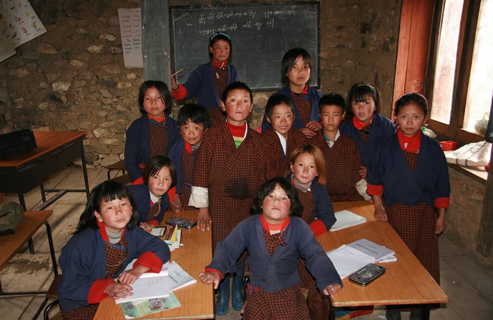
Special Information: Tashi Lakhang
In the centre of the village is a large two story building that used to be the community ‘safe-house’ where collected taxes were stored and locals kept valuables. Arrow slits on the ground floor are testimony to the buildings fortress-like history. In the time of the third King of Bhutan the building was converted into the village Lhakang (monastery), the site of the smaller original building is marked by a juniper tree and chorten near the gompa. Inside is a fine statue of Avolokishwara (Buddha to Remove Obstacles), the protector of Laya, Mayum seated on a horse (a recent donation from the current King) and many thanka, frescos, smaller statues and objects used in the annual festival that celebrates the Zhabdrung coming to Bhutan (held on the 3rd and 4th of April). The Zhabdrung created Bhutan in the 17th century after fleeing Tibet to take the protection of his friend and confidant, the King of Gasa. Every third year (the next time is 2011) the festival has dancing as well as a large puja.