Top
 

Kanchenjunga Base Camp

Trek to the base camp to the 3rd highest point on earth!

Kanchenjunga Base Camp

$2650 per person

Kanchenjunga Base Camp Trek

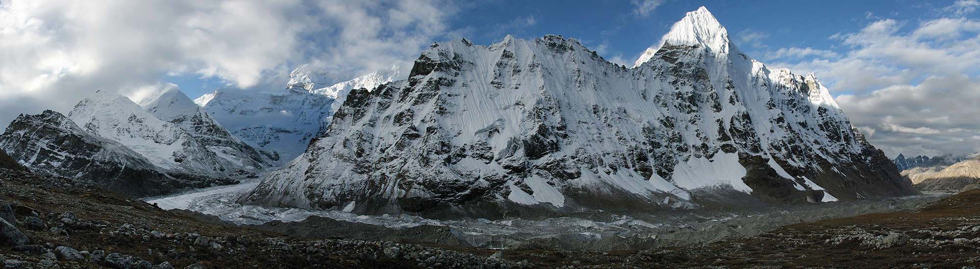
The Kanchenjunga Base Camp Trek is a journey of discovery to the 3rd highest mountain in the world.

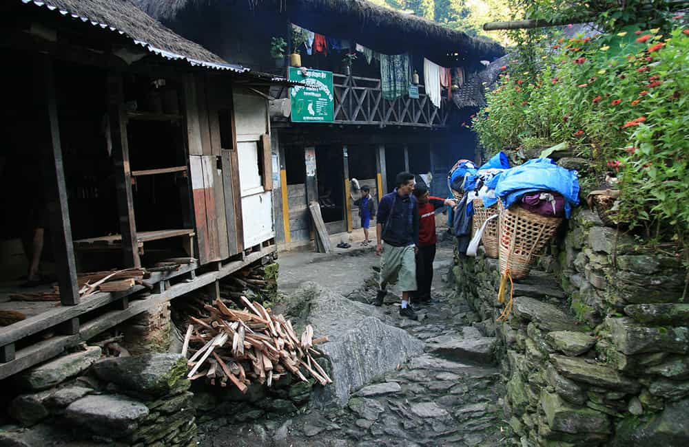
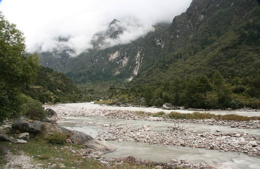
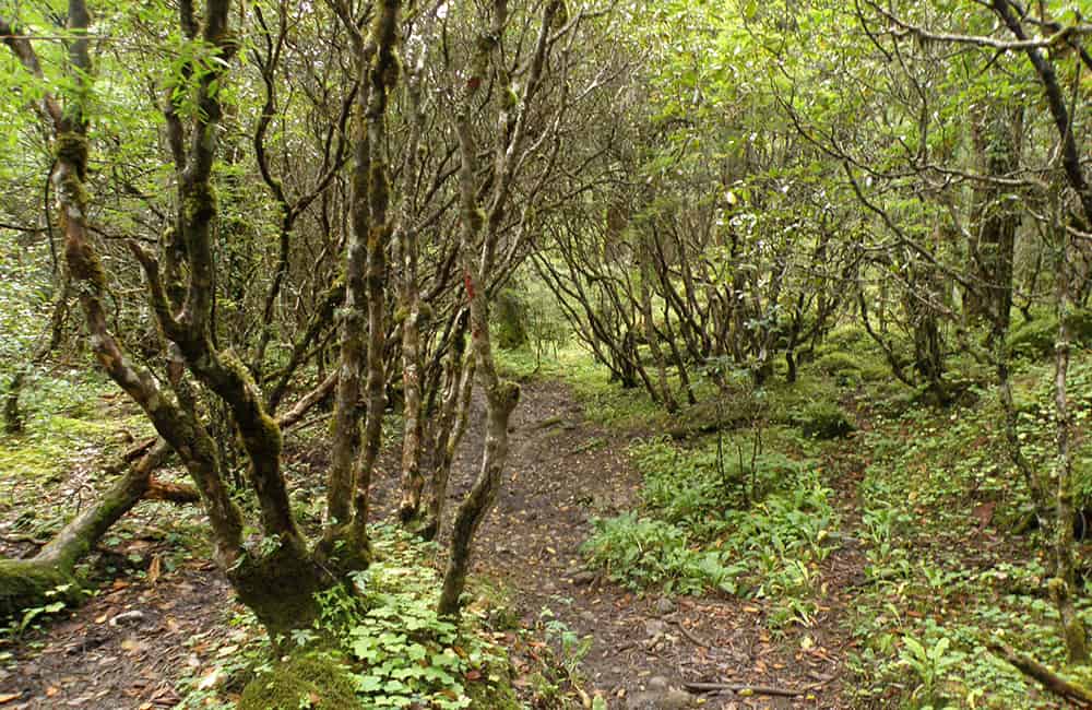
Follow trails to the remote northern base camp through stunning valleys, across glaciers and over high mountain passes. Plus there’s spectacular forests of rhododendron to explore. It’s all combined with the openhearted hospitality of the Sherpa, Limbu, Rai and Lhomi communities you can get to know along the way!

Key Points:

  • Trekking Grade: Grade 4 Energetic
  • Duration & distance: About 20 days total
  • Gradient: Some steep and arduous sections
  • Quality of path: Formed & rough tracks, some obstacles
  • Quality of markings: Limited signage
  • Experience required: Some walking experience required
  • Walking times: Less than 6½ hours per day
  • Steps: Many Steps
  • Highest point: 5143m
  • Best season: Apr-May or Oct-Nov
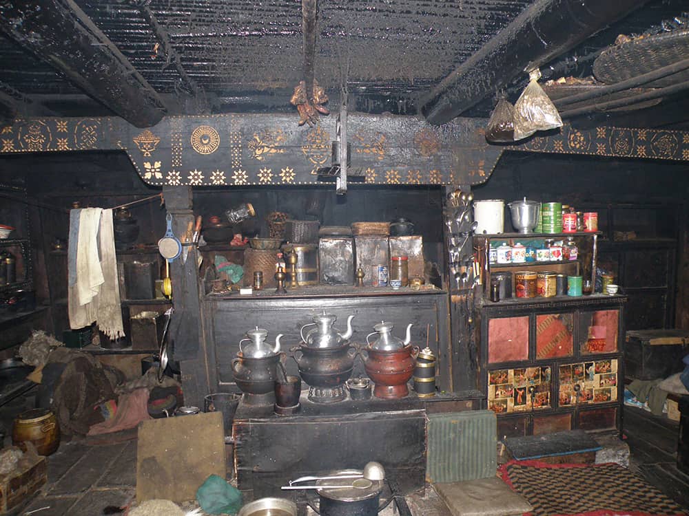
  • Accommodation: Camping or basic teahouses
  • Recommended map: NP101 GHT Kanchenjunga Region, Himalayan Map House, 2017
  • Recommended Guide Book: Nepal Trekking and the Great Himalaya Trail, Trailblazer, 2020.
Trek Grade 4

GRADE 4

Kanchenjunga Base Camp Trek

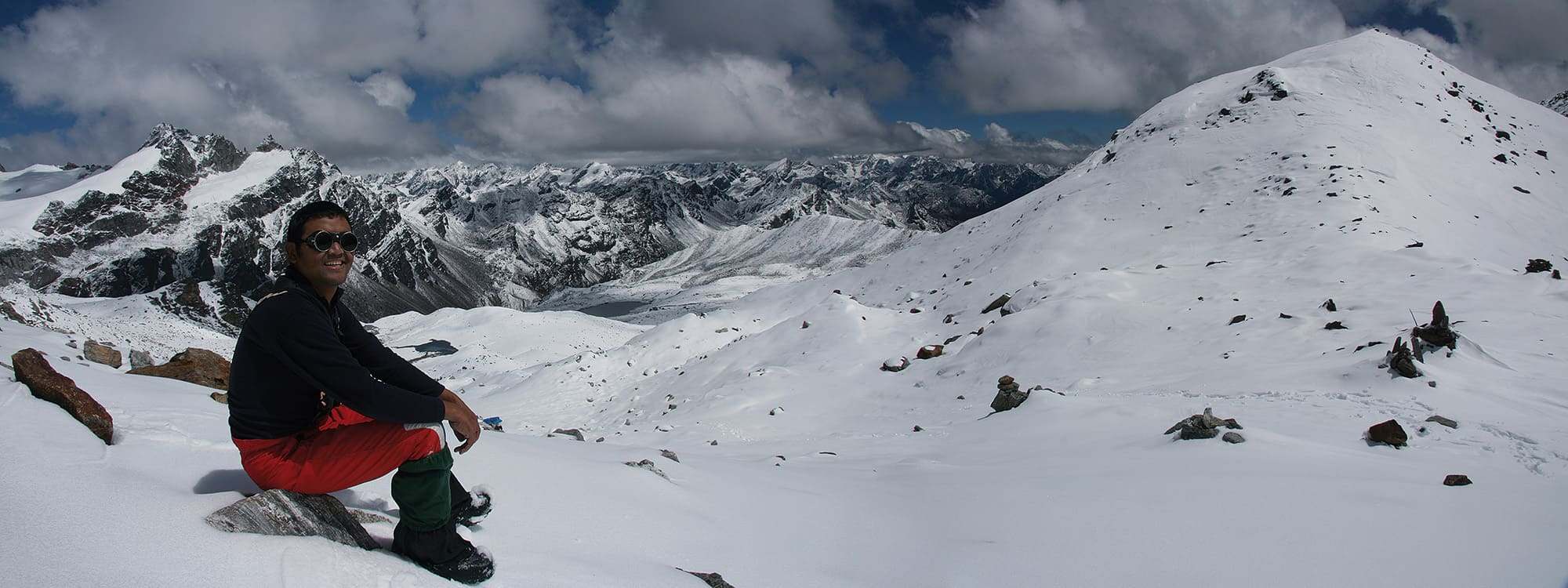
The trail and communities to Kanchenjunga Base Camp are Himalayan magic!

Kanchenjunga Base Camp Trek Olangchun Gola Typical Home

When to visit Kanchenjunga Base Camp?

There are two main seasons (April-May and October-November) for visiting Kanchenjunga Base Camp and both offer very different trekking experiences.

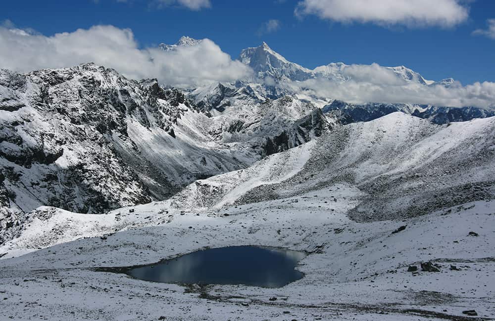
Being isolated from the other main ranges in Far East Nepal, Kanchenjunga is renowned for making its own weather and suffering from heavy monsoonal rains. After the monsoon has finished the mountains are free of lingering cloud and the views in late October and November are probably at their best. By mid-December snow closes the higher trails, which will not open again until mid to late March at the earliest. The pre-monsoon period is famous for the stunning forests of rhododendron that begin at Suketar and continue throughout the trek. These rhododendron forests are perhaps the most extensive throughout the Nepal Himalaya.

Getting to and from the Kanchenjunga region can be time consuming. In the main trekking seasons a scheduled flight operates between Biratnagar and Suketar a few times a week. For the remainder of the year, you either have to drive to Taplejung or Phidim, or charter a helicopter to Suketar.

Kanchenjunga Base Camp: Route Options

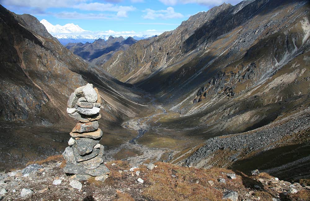
The trek to Kanchenjunga Base Camp takes about 20 days. The main trail can be combined with a number of routes to explore some magnificent wilderness areas. If you want to visit the southern Kanchenjunga Base Camp (yes there are two base camps), combine trails to Yalung via Ghunsa and Yamphudin. Another great option is over Nango La from Ghunsa to the intriguing communities of Olangchun Gola and the very remote community at Yangma. From Yangma you can explore one of the wildest hidden corners of the Himalaya!

From Ghunsa, there is a trail to Olangchun Gola (Walangchung Gola) via Nango La, which takes a total of three days to complete. The trail from Olangchun Gola back to Lelep/Sekatum takes two days. There is a convenient riverside camp at Magawa, after 3½ hours of walking on the first day.


Explore Yangma

It is possible to trek to a remote 5700m Tibetan border pass via Yangma without any additional permits. Camping is the only option, but if you have the time this is one of the most remote corners of the entire Himalaya. Allow three to four days from Ghunsa to Yangma, then four days minimum (without an acclimatisation stop) to reach the border and return to Yangma. Then it’s a further two tough days to Olangchun Gola, where it would be wise to rest for a day or two.


Visit Kanchenjunga South Base Camp

An alternative route from Suketar to Ghunsa goes via Yamphudin, Cheram (Tseram) and Yalung Base Camp (South Kanchenjunga Base Camp) to create a circular trek. It requires camping gear and takes 10-14 days depending on your route and time spent at Yalung. Note that a major landslide has made access to Yalung dangerous and it is not advisable to take laden porters.


The Border with India on Singalilla Ridge

The border with India and the spectacular Singalilla National Park are restricted areas that require a special permit issued from the police station in Chyangthapu (Phunlading) or, a valid Indian tourist visa. From Phalut, trails head almost due west to Taplejung in about six days via Sablakhu and Kande Bhanjyang. En route you pass near to Pathibhara Temple, a very popular pilgrimage site and a worthy side trip to any itinerary. Trails further westwards to the Makalu region from Taplejung either head through Dobhan or Topkegola.


Visiting the India Border Near Kanchenjunga Base Camp (north)

If you have experienced crew, or can employ a local guide, it is worth the effort to continue along a small, dangerous trail that climbs around the massive curve in the glacier to the north. This route is very rarely trekked and after three hours will require you to traverse and then walk across a glacier. Beyond here you will need ropes and associated climbing equipment. After two days you reach Jhinsang La and the border with Sikkim and Tibet. Expect to take another two days to return. Be paranoid about the weather, this is not a place to get caught out.

The small river that creates the landslide and loose rock about an hour below Kanchenjunga Base Camp flows from a glacier complex on Mera Peak. On either side of the river are two minor rocky summits of close to 6000m, which do not require permits to climb and are fantastic viewpoints.

Kanchenjunga Region Map Trailblazer Guide Book

How Much does the Kanchenjunga Base Camp Trek Cost?

To help you budget and plan, we’ve made a comprehensive costing explanation on How Much Does the GHT Cost? But here’s a simplified breakdown.

GHT Kanchenjunga base Camp Trek for 23-days estimated costs:

  • Solo as much as possible US$3,500.
  • Twin-share with minimum guiding US$2,650 per person.
  • Twin-share fully supported US$5,100 per person.

Do you have any questions about costs? Please Get in Touch for more details.

Kanchenjunga Base Camp Trek

Customisation is Normal

Want to do things a little differently? Maybe take some extra time, or go a bit faster? Or avoid technical sections or combine with other trails? Every GHT trek is different and that changes the price, but please feel free to Get in Touch to ask questions and how to customise your own trek.


Bookings

Please note that www.greathimalayatrail.com does not handle bookings for treks. We are here to inform you about the trails and logistics, but you will need to book through a registered trekking operator in Nepal. If you would like an operator recommendation or feedback on a company you are already talking to, then please Get in Touch.

Your Impacts on the Kanchenjunga Base Camp Trek

Kanchenjunga Base Camp Social Impact SOLO

Solo (Independent)

The Kanchenjunga Base Camp is quite self-sufficient so you can easily create positive social impacts. But it is remote, so transport adds to your footprint.

If you can add some extra time to do the side trips, you’ll be making a bigger positive difference to local villages.

Kanchenjunga Base Camp GHG and Waste Impact SOLO
Kanchenjunga Base Camp Social Impact TWIN

Twin Share (Independent)

The Kanchenjunga Base Camp is quite self-sufficient so you can easily create positive social impacts. But it is remote, so transport adds to your footprint.

If you can add some extra time to do the side trips, you’ll be making a bigger positive difference to local villages.

Kanchenjunga Base Camp GHG and Waste Impact TWIN
Kanchenjunga Base Camp Social Impact CAMPING

Camping (supported)

The remoteness of Kanchenjunga Base Camp increases GHG and waste impacts.

So only consider going with a camping crew if you are going to explore the remoter areas and stay an extra week or more.

Kanchenjunga Base Camp GHG and Waste Impact CAMPING

For more information about social, Green House Gas and waste impacts of treks, see The Impact of your Trek.

  • Destination
  • Departure
    Kathmandu
  • Dress Code
    Mid-altitude alpine clothing and camping equipment required
  • Included
    Kanchenjunga Base Camp
  • Grade
    Grade 4
  • Idea Date Range
    15/10/2021
  • Style of Trek
    Teahouse or camping
1
DAY 1: KATHMANDU – TAPLEJUNG/SUKETAR 2HRS
The only scheduled flights to Suketar (2420m) from Kathmandu are on Sunday and Wednesday (Tara Air), for the rest of the week you either have to fly via Biratnagar (causing an overnight delay), or charter your own flight, or use a combination of flight and bus to the large Limbu settlement of Taplejung (1820m). Flights can be delayed due to bad weather so it is wise to organise a second option, just in case. If you arrive late in the day at Suketar there are some simple teahouses next to the airport, alternatively it is an easy downhill walk for two hours to Taplejung.
2
DAY 2: SUKETAR/TAPLEJUNG – PHURUMBU - CHIRUWA 3-8.5HRS
Some extensive road building in the region now links Suketar and Taplejung with Chiruwa (via Phurumbu) and it is easy to jump on a local jeep. The road follows much of the old trekking route, so the walk isn’t very pleasant and lacks accommodation (expect an eight hour trek compared to the 3 hour jeep).For those who want to trek straight away, head downhill to Mitlung (921m, 3 hrs) via Aangshyanpati, which sits beside the Tamor Nadi. The villages you pass by are part of a historically important region in Nepal; this is where the Kirati warriors came from who first tried to unite the many kingdoms of the Himalaya into a single sovereign state.Follow the easy riverside trail for another 2.5hrs to Sinwa (Siwan, 980m) where there is a checkpost and simple teahouse. A further 3 hrs of riverside trail brings you to Chiruwa (1270m), a compact settlement of teahouses, shops and school, all squeezed between the river and steep hillside. The school sportsground, which doubles as a campsite, is 10 minutes further on and off the main trail to your left.
3
DAY 3: CHIRUWA – SUKATHUM 5½HRS
The new road is expected to follow much of the trekking route to Lelep and on to Olanchun Gola in the coming years, so you might find construction sites en-route.After the heat of the previous day it’s a relief to start walking in the cool morning air from Chiruwa. The main trail remains on the river’s south bank and if you get an early start you won’t need to walk in the sun until just before the National Park checkpost at Taplechok (1380m, 1¾hrs). It is necessary to stop and complete formalities with the National Park staff, perhaps over a cup of tea, and confirm if there are any landslides ahead, which might mean taking an alternative trail.From Taplechok, the main trail crosses a long suspension bridge to the west bank (true right) trail. You first wind through cardamom fields and then into dense forest before gradually climbing away from the Tamor Khola to Lelep (1750m, 3hrs) which has a small teahouse. A trail descends rapidly from Lelep to a suspension bridge across the Tamor Khola to Sukathum (1576m, 40 mins) and a large campsite.The old route, only used if the main trail is broken, takes the east bank (true left) trail and follows the river before climbing a little after Tamewa (1420m, 2hrs), then down to Simbuwa Khola at Hellok (1550m, 1hr) where there is a small teahouse. A trail winds around to the Ghunsa Khola valley and across a suspension bridge to Sukathum (1576m, 30 mins) and the campsite.
4
DAY 4: SUKATHUM – AMJILOSA 6HRS
This is the toughest and most dramatic day of the trek so far. Cross the suspension bridge at the Sukathum campsite to the true left bank of the Ghunsa Khola, and follow a trail through dense forest until the valley narrows into a deep gorge (2hrs). Waterfalls cascade down both sides of the valley; the sound of the river will make conversation difficult. It is essential you concentrate on the trail. Locals have built a stone walkway beneath a cliff-face along the river’s waterline, which makes for some great pictures but care is needed at all times. After negotiating this section, there is another hour of dense forest trail before you cross a bridge at the base of a steep climb. Switchbacks ascend 350m (2hrs) before the gradient eases, about one hour before Amjilosa (2308m).
5
DAY 5: AMJILOSA – GYABLA (KYAPRA) 5HRS
The trail leaving Amjilosa wastes no time in climbing a minor ridge to a sharp turn to the north (30 mins). The forest is dense and dark as you again descend towards the Ghunsa Khola at Thyanyani (2405m, 1hr) and the first of a few slippery log bridges across streams. There are a few small stone shelters here which are normally only used by herders in monsoon.For the first time in a number of days the trail doesn’t seem to continually climb up and down, as the valley widens slightly and feels less claustrophobic. After the third bridge (2hrs) the trail climbs another steep track for roughly 300m (2hrs), the last section beside a stream can be slippery so care is needed. You crest the climb and find yourself on the outskirts of the picturesque village of Gyabla (Kyapra, 2730m). For those with time and energy there is a pleasant walk up behind the village with views of the Birdhungga Danda.
6
DAY 6: GYABLA (KYAPRA) – GHUNSA 4½HRS
After the previous week this day marks a noticeable change in the flora and fauna along the trail. At first, the trail seems much like that of the previous afternoon; a broader valley bottom permits views of the river and hillsides, which continue for 1½ hours. Then the trail climbs for 200m (1hr) and suddenly you notice rhododendron, camellias and azaleas rather than bamboo and cardamom beside the trail. The village of Phale (Phere, 3140m) is spread over a large area. The first houses are the winter village for Ghunsa, before the village proper (30 mins). This is a Tibetan refugee settlement where it’s possible to buy handicrafts and homemade rugs from some of the locals, ask around when you arrive and potential sellers will soon find you! From Phale a pretty trail winds through dwarf conifer and pine forest before crossing a suspension bridge (to the true left bank) and arriving at Ghunsa (3595m, 1½hrs) in a broad section of valley. Waterfalls fall from the steep cliffs above this Sherpa village that feels like the edge of nowhere on a cloudy day.
7
DAY 7: GHUNSA ALL DAY
As you have now passed the 3000m mark, it is wise to take an acclimatisation rest day at Ghunsa. You can relax and explore the village. Sherpa hospitality is legendary and the local school is proud to show off its computer (you can charge iPods here for a donation).Alternatively, explore the Yamtari Khola which boasts a fantastic view of Jannu (7711m) from the south – first follow the water pipe for the village hydro-generator and climb on the true right side of the river until you reach some herders’ huts, then cross boulders to reach the viewpoint. This valley is also the route to the disused and dangerous Lapsang La (5161m), as well as Sele La (4290m) and Sinion La (4440m) both of which offer interesting route variations to/from Yalung if you have camping gear (see Other Trails in the Kanchenjunga Region).Special Information:The Kanchenjunga School ProjectThe Kanchenjunga School Project (KSP) funded the building of the Ghunsa and Phale schools and medical clinics in 1990 and 1992. Since then the KSP has maintained these facilities, provided salaries and training for the health-care worker, a midwife and pre-school teachers. The Nepal government provides primary-school-level teachers and some support for the health posts. KSP always need additional support and donations, which can be made locally through businesses in the villages or through : www.kanchenjunga.org.
8
DAY 8: GHUNSA – KHANGPACHEN (KHAMBACHEN) 5½HRS
Deodar pine and rhododendron forest, grassy glades dotted with wild flowers, and increasingly spectacular mountain scenery combine into what is perhaps the most impressive section of trail along the entire trek. It will take about 1½ hours to reach a bridge that crosses to the true right bank of the Ghunsa Khola and Rampuk Kharka (3720m). Note that the bridge is often blocked with sticks to prevent yaks from wandering. The trail now climbs almost 400m past, and then through, a large landslide (beware of rockfall) beside the terminal moraine of the Kanchenjunga Glacier to 4100m (2½hrs). A brief traverse of the hillside offers a good view of Jannu before descending to the yak farming settlement of Khangpachen (Khambachen, 4050m, 1½hrs).
9
DAY 9: KHANGPACHEN (KHAMBACHEN) ALL DAY
A day to acclimatise is normally taken at Khangpachen (Khambachen), where there are two great day walks to help you adjust to the 700m altitude gain tomorrow. One route is to explore the valley directly behind Khangpachen and walk up to the base of Tha Nagphu (5980m), a massive snow and rock dome that you can see from the village. Alternatively, for those feeling fit, cross the river and climb the true right (left-hand) side of the Kumbhakarna Glacier lateral moraine to the popular pilgrimage site beneath the massive vertical north face of Jannu – there is a large boulder and plenty of prayer flags to mark a viewpoint.
10
DAY 10: KHANGPACHEN (KHAMBACHEN) – LHONAK 5HRS
The trail away from Khangpachen is surprisingly easy as you gradually climb scrubby lateral moraine for one hour. Then comes perhaps the hardest and most dangerous section of the entire trek, a climb up a long section of landslide, mostly across large boulders, which takes about 2½ hours. It is wise to keep moving, however slowly, across this section and complete the climb as early as possible as the risk of rockfall increases throughout the day. Once across the stream from the waterfall section the trail climbs steeply (beware of rockfall) for a short section to the top of an ancient lateral moraine at 4670m (a popular lunch stop), where the gradient eases as you cross some scrubby and grass-covered moraine. On the far side is the Lhonak Khola, which you follow to a seasonal bridge and a few stone shelters at Lhonak (4780m, 2hrs).
11
DAY 11: LHONAK ALL DAY
The large sandy bed of the Lhonak Khola offers an inviting walk for an acclimatisation trip. It is important that you are prepared for and understand the hazards of river crossings if you want to fully explore this valley. It is possible to explore a rough track along the western edge of the Lhonak glacier to the confluence of the Chabuk and Chijima glaciers at 5080m, 5 hours’ return. Alternatively, you can enjoy the views of Gimmigela, Wedge Peak, Nepal Peak and Tent Peak (Tharpu Chuli) that line and head the valley to the east. Try to spot the rock pinnacle on the far side of the glacier, just at the point it turns south-west.
12
DAY 12: LHONAK – KANCHENGJUNGA BASE CAMP 4HRS
The trail from Lhonak climbs gently along the massive lateral moraine of the Kanchenjunga glacier for the first 2 hours. It’s hard not to stop and admire the views of the peaks and the glacier below. A short steep section of loose rock and landslide formed by a side river will take 40-60 minutes to cross. The trail then climbs more gently for another hour before you reach the few stone huts of Pangpema and Kanchenjunga Base Camp (5143m). Expedition groups will probably not have a permanent camp here as an advanced base camp across the glacier has become a preferred spot.
13
DAYS 13-20
Return to Suketar along same route, then fly to Kathmandu