Top
 

Annapurna Sanctuary

Easy, comfy and spectacular! What more do you need?

Annapurna Sanctuary

$885 per person

Annapurna Sanctuary

Easy, comfy and spectacular! What more do you need?

Annapurna Sanctuary Trek

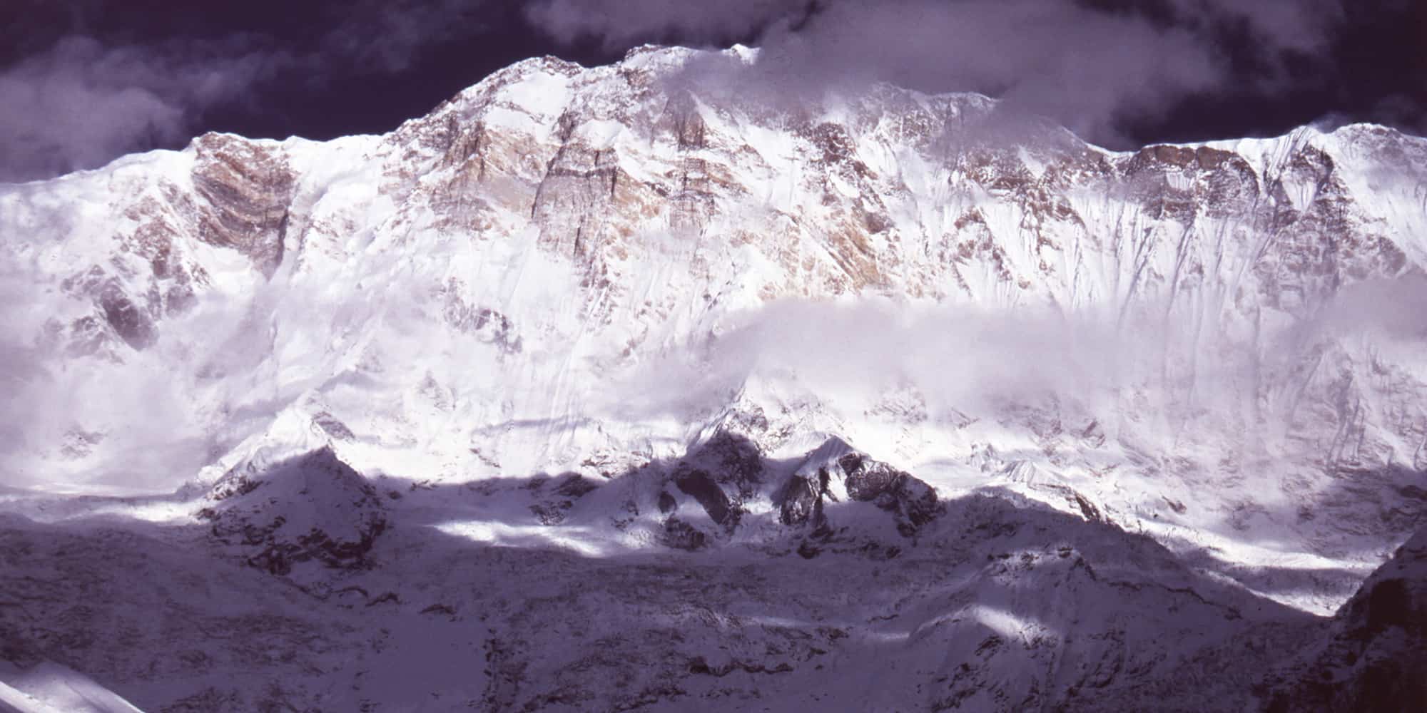
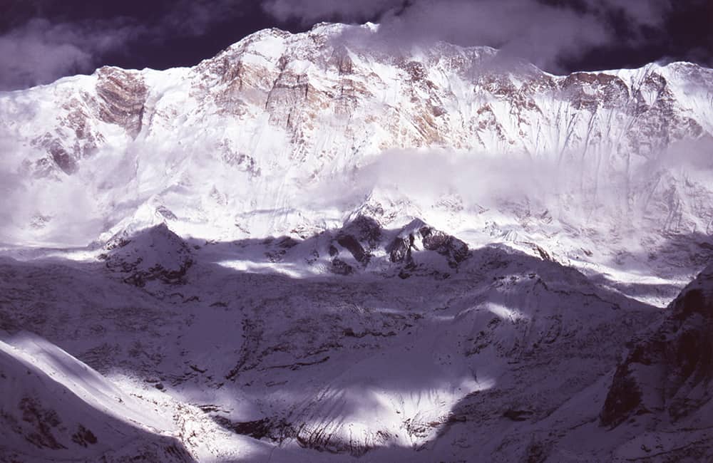
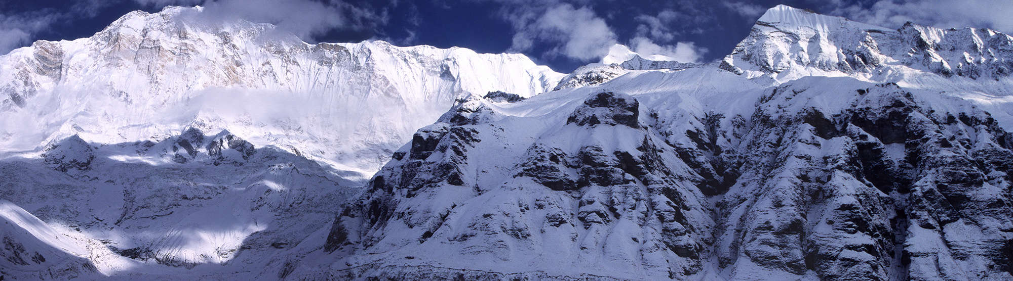
The Annapurna Sanctuary is a fabulous mountain amphitheater with magnificent views of the surrounding peaks. En route there are relaxing hot springs, lush forests and fun-loving Gurung communities. Plus there’s many wonderful extension options if you have a little more time.

Is this tour for me?

Travel Style: Active with Guide in Teahouses

Hiking, trekking, adventure with a guide, and staying in teahouses.

Physical Rating: 3 - Energetic

Trail is sometimes on a rough track with obstacles and arduous sections with limited signage.

Service Level: Basic Teahouse

Comfy, family-owned teahouses with all meals provided along the trail.

Check Your Visa Requirements

Before booking, use our handy entry requirements tool so you know which documents you need to enter and travel through the countries on your trip.

Recommended Group Size

Small group experience; Max 12, Avg 2 to 8

Age requirement: 12+

All travellers under age 18 must be accompanied by an adult.

When to Trek to Annapurna Sanctuary?

Lying to the south of the Great Himalaya Range, the Annapurna Sanctuary region has a typical monsoonal climate. A long rainy season from June/July through to the end of September. This is followed by period of stable weather through to mid-January. Later winter storms frequently fill the Sanctuary with large amounts of snow, often burying the teahouses completely. The spring thaw is in March and the trails soon re-open through monsoon.

The teahouses along the Annapurna Sanctuary trail remain open for almost the entire year. However in recent years avalanche danger (resulting in deaths in 2020) closed the trail in March. If you want to trek then please be sure to check weather forecasts and local information every day!

Annapurna Sanctuary
From 8-10 days

Annapurna Sanctuary

Difficulty

days

Postive Impacts

GHG Footprint of 15kg CO2e per day

Social Impacts: 60% of trek expenses support local communities directly

Why you will love this Trek

Trekking Grade: Grade 3 Energetic Stunning mountain views Super friendly villages Beautiful forests Enchanting cultures Comfy teahouses
Annapurna, Naar and Phu
ANNAPURNA sanctuary

Annapurna Sanctuary: Route Options

The Annapurna Sanctuary has remained relatively unchanged since the first trekking boom in the mid-1990s. This is probably because local investment concentrated on the Circuit route and there are limited high trail combination options. It’s easy to link this trek with Poon Hill and/or Khopra Ridge (Khopra Danda) via Tadapani.To the east of Landruk you could connect to the Mardi Himal trails and even go cross country as far as Siklis and the old (and high) monsoon route over the Namun Bhanjyang to Timang.

Annapurna Circuit, Naar and Phu

How can your Annapurna Sanctuary Trek create positive impacts?

To help you budget and plan, we’ve made a comprehensive costing explanation on How Much Does the GHT Cost? But here’s a simplified breakdown.

Estimated Cost US$2,095

Trek cost per person (twin share)

Total GHGe per trekker

54kgCO2e

Total GHGe per trekker per day

6kgCO2e

Average per capita EU GHGe = 20kgCO2e per day (www.statistica.com)

Go Local equals positive impacts

What we do…

…make Positive Impacts

% of Trek Cost

Go Local Transport

Use Local Accommodation

Eat Local Meals

Waste Management

Highly Experienced Guide

Biodiversity

Locally supplied transport reduces drive times and fuel usage

Locally supplied accommodation reduces commissions

More nutritious, fresher ingredients, no packaging

Carry out ALL PLASTIC, avoid snacks and soda drinks

A knowledge bank for your peace and wellbeing

National Park entry fee for you and the team

Administrative and office costs

22%

38%


0%

20%

15.2%

4.8%

Do you have any questions about the trail, when to go or the costs? Please Get in Touch to ask an expert and for more details.

Bookings

Please note that www.greathimalayatrail.com does not handle bookings for treks. We are here to inform you about the trails and logistics, but you will need to book through a registered Local Operator LINK in Nepal. Get in Touch

Customisation is Normal

Want to do things a little differently? Maybe take some extra time, or go a bit faster? Or avoid the technical sections? Every GHT is different and that changes the impact and the price, but this it totally normal and your Local Operator will be able to adjust plans without problems. Get in Touch

Social and Environmental Impacts

The GHT has been designed around the principles of Responsible Sustainable Tourism and we do our very best to make sure that the GHT is good news for the locals and the environment along the trails. To walk the talk, we have pioneered the development of social impact assessment and Greenhouse Gas emissions, and environmental impacts like waste created for each trek. There is more information about how we calculate impacts at Impact of Your GHT Get in Touch

Itinerary

DAY 1: KATHMANDU – MACHHAKHOLA

After an early start, you should reach Machhakhola after lunchtime and have time to relax in the afternoon with views of the Budhi Gandaki river.

DAY 2: MACHHAKHOLA – JAGAT 6.5 HRS

We follow the dirt road north out of the village and soon reach Khorlabesi (970m, 1 hour) and then on to Tatopani (990m, 1 hour) where the waterspouts make a good washing stop. At the end of the village, cross a suspension bridge to the true left (east) bank and continue through sometimes dense forest to Dobhan (1070m, 1.5 hours), where there are teahouses.

Continue on a broad trail on the true left bank of the river to Yaruphant (1170m, 1 hour), where there are a few teashops on a broad grassy slope. From here, the trail climbs about 200m up what was once an enormous landslide that blocked the Budhi Gandaki. The trail descends a little from the top of the climb to the broad riverbed. In the trekking seasons, there are some temporary teashops (1.5 hours from Yaruphant) at the confluence of the Yara Khola.

Vertical cliffs rise on both sides of the valley as a spectacular trail continues on the true left (eastern) bank for 15 minutes to a bridge, which you cross to the true right bank and where the Budhi Gandaki has cut a narrow gorge. After a short climb and descent of 20 minutes, you reach a flat area where there is a teashop and two grassy campsites signposted ‘Jagat’. The village is 10 minutes further up the trail, behind a rocky spur. As you enter Jagat (1340m) on a good stone-paved trail, there is a community-owned campsite on your left and some teahouses before the Manaslu Conservation Area Project (MCAP) and police checkpost. Jagat is a common village name in the high mountains as it means ‘customs post’ and is the traditional tax collection point for trade to and from Tibet. 

DAY 3: JAGAT – DENG 6 HRS

Beyond the village is the Pangaur Khola, which is crossed using stepping stones and log bridges. The trail now climbs an easy gradient to a chautara (1 hour), where there are good views of Shringi Himal to the north. Descend to Sirdibas (1420m, 40 mins) and turn a sharp left turn at the end of the village to ascend a stream for about 50m before turning sharp right for the main trail. Continue to a suspension bridge, which you cross to the true left bank of the Budhi Gandaki (there is a police checkpost at the bridge), and then climb 200m to the village of Phillim (1570m, 40 minutes), another MCAP checkpost and teahouses.

This next section of trail is spectacular and well worth the effort of a long day’s walk. Ekla Bhatti (1650m) is about 45 minutes from Phillim, but take your time and admire the waterfalls on the west side of the valley. After the monsoon, there is a large waterfall beyond Ekla Bhatti, after which you enter a scrubby forest that gives way to large pine trees. Forty minutes from Ekla Bhatti you reach a trail junction, where you turn left (the right-hand trail goes to Tsum, see pp000-00). Descend (5 minutes) to and cross a bridge, where the trail begins a gradual climb as the valley turns westwards. After the initial climb away from the bridge there is a small trail junction where you turn right (the left trail climbs steeply to Nyak).
Another bridge across the Budhi Gandaki is reached in 45 minutes, which you cross to the true left (north) bank to avoid a steep cliff. In another 15 minutes, you cross back to the true right (south) bank using a suspension bridge. In 20 minutes, you will reach Pewa and the junction with the high trail from Nyak (this is where you join the Circuit trail from Rupina La). It’s a good campsite and teahouses at Deng (1860m), which is now 30 minutes away along a pleasant trail with good views of the narrow gorge cut by the Budhi Gandaki.

DAY 4: DENG – NAMRUNG 5 HRS

As the Manaslu Circuit trail turns westwards, the shape of the homes changes to squat, dry-stone structures to reflect the changing demands of climate and the architectural influences of Tibet. Mani walls, chorten, and kani are common along the trail. Rice and wheat are replaced by buckwheat, barley, and maize in the fields. The trail descends to a suspension bridge, which you cross to the true left (north) bank of the Budhi Gandaki and then climbs roughly 100m to Rana (1910m, 35 minutes).

The trail now climbs an easy gradient beneath the village of Umbaie (above which is Shringi Gompa) before winding through the Shringi Khola gorge to Bhi (1990m, 45 minutes). Follow an undulating trail through sparse pine trees and hamlets to a large kani (1½ hours) that marks the entry to the Prok and Ghap communities. The paintings and mani stones on this kani are in good condition. The fierce blue and red characters on the kani ceiling and walls are protectors who are meant to stop evil spirits from entering the villages beyond. There is a teahouse and campsite at Prok, only 10 minutes further on.

The trail now gradually swings back to the river, which you cross to the true right bank via a suspension bridge. It’s a slight climb to Ghap, where there are a couple of teashops. The valley narrows and you pass through fine broad-leaf forest to a spectacular canyon carved by the river (45 minutes), which you re-cross in another 15 minutes on a larger bridge.
Note: the Himal Chuli Base Camp trail veers left here and climbs the Sherang Khola valley.
From the second bridge, the trail climbs more steeply for almost an hour to Namrung (2630m), where there is a campsite and teahouses.

DAY 5: NAMRUNG – SAMA (RYO) 5.5 HRS

Leave Namrung by crossing Therang Khola along an easy trail that passes a waterfall on your left before entering the scattered village of Barchham (20 minutes). The trail now climbs a bit less than 300m on an easy gradient to Lihi (2920m, 50 minutes), where there is a campsite and teahouses. Descend and cross the Hinan Khola on the far side of the village and ascend an easy trail to Sho (2880m, 45 minutes). It is now an easy uphill gradient to Lho (3180m, 1 hour), where there is a campsite and teahouses, but take your time and enjoy the evolving mountain panorama around you.
Manaslu dominates the skyline at Lho and if you have the time explore the village’s mani walls, kani, and Ribang Gompa, which sits on a hill above the village. The trail descends to the Thusang Khola and then climbs a steady gradient for 300m to Shyala (80 minutes), a community of mainly log cabins where there is another campsite and teahouses. Next, the trail dips through the Numla Khola before descending slightly and then becoming flat to Sama (Ryo; 3520m, 70 minutes), where there are teahouses and campsites to choose from at the far end of the village.

DAY 6: SAMA (RYO) ALL DAY

It is a good idea to spend a day in Sama (Ryo) exploring the village and/or some of the surrounding viewpoints as part of an acclimatisation programme. One of the most popular places to visit is the Pung Gyen Gumba beneath the east face of Manaslu. To get there, backtrack on the Shyala trail to a junction before the Numla Khola, where you turn right and begin a long and sometimes steep climb for 2 hours and 20 minutes. Once you have crested the ridge above the river the gradient eases and ahead you will see the small gompa. You will be expected to provide a donation to the gompa if you visit it. Higher still is a cave gompa and hot springs, but relaxing in the grassy kharka near the gompa and enjoying the view of Manaslu is a popular pastime before returning to Sama in 1½ hours. Alternatively, explore the village and gompas of Sama, or take a local guide to Birendra Kund for reflections of Manaslu and its northern icefall. 

DAY 7: SAMA (RYO) – SAMDO 2.5 HRS

An easy day to Samdo can be combined with a side trip to Birendra Kund. Leave Sama on a broad trail that runs north from the village across grassy kharkas. Remain on the western side of the valley, following a trail that runs parallel to the Budhi Gandaki. After 45 minutes cross the outflow from Birendra Kund to the summer herding area of Kermo Kharka where there is an excellent view of Manaslu from the impressive mani wall.
The trail continues to climb an easy gradient for an hour before dropping to a bridge over the river. Climb to an impressive kani, which marks the entry to Samdo (3875m, 30 minutes). This is a Tibetan refugee settlement of about 40 homes, created after the Chinese occupation of Tibet. The border runs along the top of the hills above Samdo and makes an ideal side trip.

DAY 8: SAMDO – LARKYE LA DHARAMSALA 3 HRS

From Samdo the trail descends to a bridge across the Gyala Khola. Climb the trail on the far side to a large pile of mani stones (40 minutes), where you can look down on Larkye Bazaar, a trading ground (there are no buildings as such) where Tibetans sell large herds of goats before the Nepali festival of Dashain in October/November. The trail now climbs an easy gradient with views of Larkye Peak and the north face of Manaslu for 2 hours and 20 minutes to Larkye La Dharamsala (4460m), where there is a teahouse. Take some time to check that you are well prepared to cross the pass tomorrow.

DAY 9: LARKYE LA DHARAMSALA – LARKYE LA – BIMTANG 7 HRS

The longest and toughest section of the Manaslu Circuit now awaits, but also the most magnificent views – Himalayan majesty and grandeur all around. It is wise to start before sunrise and climb an ablation valley to view of Cho Danda. Although there are some prayer flags at the top of the Ablation Valley (4690m, 80 minutes) you are not at the top of the pass. The trail now crosses rough undulating moraines for 30 minutes to another dharamsala (4905m). From here the trail begins to climb more steeply to the top of Larkye La (5135m, 1¾ hours), where you will be greeted by magnificent views of the upper Bimtang valley and a roofless dharamsala. Views of Himlung and Cheo Himals, Gyagi Kang, Menjung, Kang Guru, and Annapurna II fill the horizon. Descend from the pass down a steep slope, which is often snow-covered and icy (and may require a handline), for 1½ hours. Beneath you are three glaciers spotted with numerous turquoise lakes; head for the ablation valley to the left of all the glaciers. An easy gradient then leads down to the campsite at Bimtang (3590m, 2 hours), which is serviced by four competing teashops staffed by pretty Gurung women.

DAY 10: BIMTANG – KHARCHE 5.5 HRS

Continue to follow the ablation valley south from Bimtang, which soon gives way to lateral moraine after 10 minutes. There are good views of the west face of Manaslu from here. Cross a branch of the glacial melt and then turn left, over some more moraine before crossing the main stream of glacial melt and then climbing a ridge of lateral moraine topped by some prayer flags (20 minutes).
The trail descends a little steeply through pine and rhododendron forest for 15 minutes before levelling to a gentle downhill gradient. As you descend towards the Dudh Khola through forest the trail passes through a few kharka. There is a lone teashop at Yak Kharka (aka Sangure Kharka, 3020m, 80 minutes) after a copse of mountain pepper trees. From here the trail can be a little difficult to follow across some large landslides and through scrubby forest to the scattered settlement of Kharche (1 hour).

DAY 11: KARCHE – DHARAPANI 4 HRS

The trail now climbs an imposing ridge that juts into the centre of the valley before a long descent to the many fields of Goa (2515m, 1.5 hours), where there are two teahouses. It is now a gentle downhill to the large Gurung village of Tilije (2300m, 50 minutes), where you cross a bridge pass a new school, and begin road-trekking again. After 20 minutes you come to a trail junction; turn right and descend to Thonje (1965m, 50 minutes), which you reach after crossing a long suspension bridge. Once at the village continue on the road to a T-junction in front of a teahouse. Turn left onto a dirt track and pass the school; after a short descent, cross a suspension bridge over the Marsyangdi river to Dharapani (1965m, 10 minutes), where there is a police checkpost and many comfortable teahouses. 

DAY 12: DHARAPANI – BESISAHAR – POKHARA/KATHMANDU

A road has been built from Besisahar to Manang, so you can take a jeep service from Dharapani and then you can transfer to a bus in Besisahar for services to Pokhara or Kathmandu. 

Trip Information

  • Trekking Grade: Grade 3 Moderate
  • Duration & distance: About 8 days total
  • Gradient: Short steep sections
  • Quality of path: Formed track, some obstacles
  • Quality of markings: Signs at beginning, end and major intersections
  • Experience required: Some walking experience required
  • Walking times:  Less than 5¾ hours a day
  • Steps: Steps most days
  • Highest point: 4234m 
  • Best season: Mar-May/Oct-Jan  
  • Accommodation: Camping and teahouses
  • Recommended Guide Book: Nepal Trekking and the Great Himalaya Trail, Trailblazer, 2020
  • Recommended map: NP107 GHT Series Annapurna, Naar & Phu, Himalayan Map House, 2017

20-35 days

20-35 days

Tea – House Trekking with a Guide

Trekking with a Camping Crew

Make Sure You Include in Your Budget

Transportation

Private or Public Bus/Jeep,
plus walking conditions.

Accommodations

ask for GHT Check-In Point Teahouse
Lodges (6 nights).

Safety & Wellbeing

Does your guide have Wilderness First
Aid training?

Other things to consider:

  • Special care airport pickup
  • English or your preferred language speaking local guide for the trek and city tours
  • All necessary permits for trekking
  • Local porters could be included on the trek
  • All transport between destinations and to/from included activities

Choose Your Local Operator

  • Destination
  • Departure
    Kathmandu
  • Dress Code
    Mid-altitude alpine clothing and camping equipment required
  • Included
    Annapurna Sanctuary
  • Grade
    Grade 3
  • Idea Date Range
    15/10/2021
  • Style of Trek
    Teahouse
1
Day 1: Pokhara–Birethanti–Ghandruk 6hrs+
There are many taxis plying the new road route from Pokhara to Kimche (3hrs’ drive), or you can take a bus to Birethanti (1050m) and begin your trek along the road route (add an extra 4½ hours of walking time). To begin at Birethanti first cross the metal bridge to the true right bank of the Modi Khola and register at the ACAP checkpost. The trail heads north from Birethanti, up the Modhi Khola valley, following a rough dirt-road route. Currently the road ends at Kimche (1640m) where you then follow an impressive stone-paved trail, climbing all the way to Ghandruk (1940m, 3hrs). This village is an amazing example of stone-work and is worth spending a day exploring. Spread over the entire hillside there are views of the Annapurna range which are best appreciated from one of the many bakery cafés in the village. Note: It is easy to link Birethanti and Ghandruk with trails to Poon Hill, adding another 2 days to this itinerary, see Poon Hill and Khopra Ridge
2
Day 2: Ghandruk–Chhomrong 5hrs
There are a number of route options between Ghandruk and Chhomrong. The fastest and most popular is via Kot Danda and Kimrong. Both the two other routes descend into the Modi Khola valley (via New Bridge and/or Jhinu) and take considerably longer. The New Bridge option is only worth considering if you are not going to return on the Chhomrong–Landruk route (see day 7), which passes the hot springs. To reach Kot Danda, follow the main trail out of the north-western end of the village, which heads to Tadapani. To your north rises the impressive bulk of Annapurna South and the dramatic Machhapuchhare. Once you leave the village it is easy to see Kot Danda on a ridge across a small valley and the trail route as it branches away from the Tadapani trail. It’s a pleasant stroll for 2 hours to Kot Danda where there are some tea shops to sit and enjoy the view. It is a steep downhill to Kimrong (1860m, 45 mins) where groups often stop for lunch. A steady climb for 1¼ hours brings you to Taulung (2180m) and Chhomrong (2170m) is less than an hour further.
3
Day 3: Chhomrong–Himalaya 4¾hrs
Descend a stone stairway and cross a bridge to the true left bank of the Chhomrong Khola and then climb through some small terraces to Tilche (2010m, 40 mins). Beyond the village, enter a bamboo forest and traverse above Bhanuwa and enter the Modhi Khola valley, which forms a striking V shape ahead. The trail climbs to the last permanent settlement of Sinuwa (2360m, 35 mins) and continues through oak and rhododendron forest interspersed with large stands of bamboo. After another 45 minutes you should reach Kuldhigar (2540m), where there are a few teahouses and an ACAP post. From here onwards, sections of the valley are affected by avalanche debris falling from the flanks of Hiun Chuli; you should check with ACAP staff if the trail is clear and safe. A short climb is followed by a steep descent on a well-prepared paved track to Bamboo (2310m, 30 mins), where the trail now deteriorates with many tree roots and slippery sections forcing your pace to slow. Three small bridges cross tributaries en route to Dobhan (2600m, 1¼hrs), where there are a few teahouses. From Dobhan the forest becomes more impressive with large rhododendrons covered in Spanish moss and pockets of orchids. The locals believe that the god Baraha protects the Sanctuary. Accidents are frequently explained as the unfortunate outcome of upsetting him by taking meat or eggs beyond a small shrine you’ll find opposite a pretty ‘weeping waterfall’. In an hour you reach the village of Himalaya (2920m), so named because there was initially a single teahouse here, called Himalaya, and the village sprang up around it once the trek became popular.
4
Day 4: Himalaya–Machhapuchhare Base Camp (MBC) 3¼hrs
Continue to climb through dense forest to a large rock overhang, called Hinku Cave (3170m, less than an hour), once the site of a teahouse. Deurali (3230m, 45 mins) can be seen ahead, beyond another avalanche-prone area. The valley broadens and a fine birch forest fills the far bank before you pass a small snow cave that has been slowly melting for years. Two obvious rock pillars mark the ‘gateway’ to the Sanctuary, which suddenly opens out to broad grassy slopes and a series of teahouses at MBC (3700m, 1½hrs). The last expedition to climb this sacred mountain was in 1957; out of respect, it stopped short of the summit. Many trekkers begin to feel the effects of altitude at MBC, so it is a good idea to initially rest and enjoy the views of Machhapuchhare, Gangapurna and Annapurna South on arrival. If you are still feeling symptoms of altitude sickness later that evening or the following morning, you should rest for the day or consider descending to Himalaya.
5
Day 5: MBC–Annapurna Base Camp (ABC) 2hrs
The trail climbs ancient moraine, now covered in grass, to the west of MBC. There are many trails that wind slowly upwards to ABC (4130m, 2hrs), some on the edge of the moraine for views of the Annapurna South Glacier, others towards the lower slopes of Hiun Chuli (giving a better perspective of the Sanctuary). There are four teahouses at ABC, which was the site for the 1970 British Annapurna Expedition, and a day spent wandering further up the valley or along the edge of the nearby moraine is a great way to absorb the majesty of the Himalaya.   Side trip from Annapurna Base Camp (ABC) For those who are acclimatised and have the time, there is an excellent viewpoint on the far side of the Annapurna South Glacier and above the Tent Peak Base Camp. From ABC descend to the glacier and look for a trail marked by cairns, which crosses the glacier to a large gully (beware of rockfall!) cut by a stream through the moraine on the far side of the valley. Climb to the left of the gully to a grassy moraine and head west as a small trail winds around the base of some buttresses. Before the rim of another deep gully (4350m, 1½hrs), climb straight up the face of a buttress which soon begins to level to a point where you can cross a small stream to the west bank and ascend a broad grassy slope that leads up to a viewpoint (4890m, 2hrs) of the entire western basin of the Sanctuary. To the east is Tent Peak (Tharpu Chuli), to the north-east is Singu Chuli, to the north is Khangsar Kang (Roc Noir) and to the west is the massive face of Annapurna I (8091m). The southern horizon is filled with Annapurna South and Hiun Chuli. Your return to ABC will take 2¼ hours.  
6
Day 6: ABC–Bamboo 5½hrs
Backtrack along the same route to Bamboo (2310m, 4½hrs), or if trail conditions allow continue on to Sinuwa
7
Day 7: Bamboo–Landruk 5¼hrs
Reach Sinuwa (2360m) in one hour from Bamboo and continue to Taulung (2180m, 1½ hours from Sinuwa). At the end of the village the trail forks: the right leads back to Kimrong, but take the left trail, which descends steeply to Jhinu (1780m, 45 mins). Before the track swings sharply west (into the Kimrong Khola valley) there is a small sign for a hot spring about 40 minutes to the north in the Modhi Khola valley. If you don’t want a hot bath, continue along the trail as it descends to a bridge, which you cross to the true right bank of the Kimrong Khola and then climb the far bank to Samrung (1750m, 30 mins). After Samrung, descend to the Modhi Khola on a trail heading towards New Bridge (1340m, 20 mins). Just before the final descent to the bridge there is a sign to another hot springs down a scrambly track to the north of the bridge. Cross the bridge to the true left bank of the Modhi Khola and pass through some small villages before a short climb to the large Gurung village of Landruk (1565m, 1¼hrs).
8
Day 8: Landruk–Pothana– Pokhara 4¼hrs
The trail now climbs an easy gradient sometimes on soft ground and sometimes on stone paving to Pothana (1890m, 2½hrs), which straddles the Manjh Danda ridge. There are fine views of Machhapuchhare and the Annapurnas to the north from along the next section of trail, making this one of the best final days on a trek in Nepal. Descend from Pothana along a large ridge trail to Dhamphus (1650m, 1hr), before a final steep descent through forest to the taxi stand and car park at Phedi (1130m, 45 mins), which is only a short drive from Pokhara. Note: From Landruk and Pothana there are dozens of trails heading east and towards Pokhara that can add a touch of delightful cultural immersion to the end of this itinerary.

GHT India Short Treks

GHT Bhutan Short Treks

GHT Immerse Mustang

GHT Immerse Dolpo

GHT High Bhutan

GHT High India Himalaya

GHT Alpine High Route

GHT High Nepal Traverse

Rolwaling and Tashi Labsta

Upper Dolpo Circuit

Book Now

For more information. Please complete this form.

Ask Expert

For more information. Please complete this form.