Langtang Valley
Langtang Valley Trek
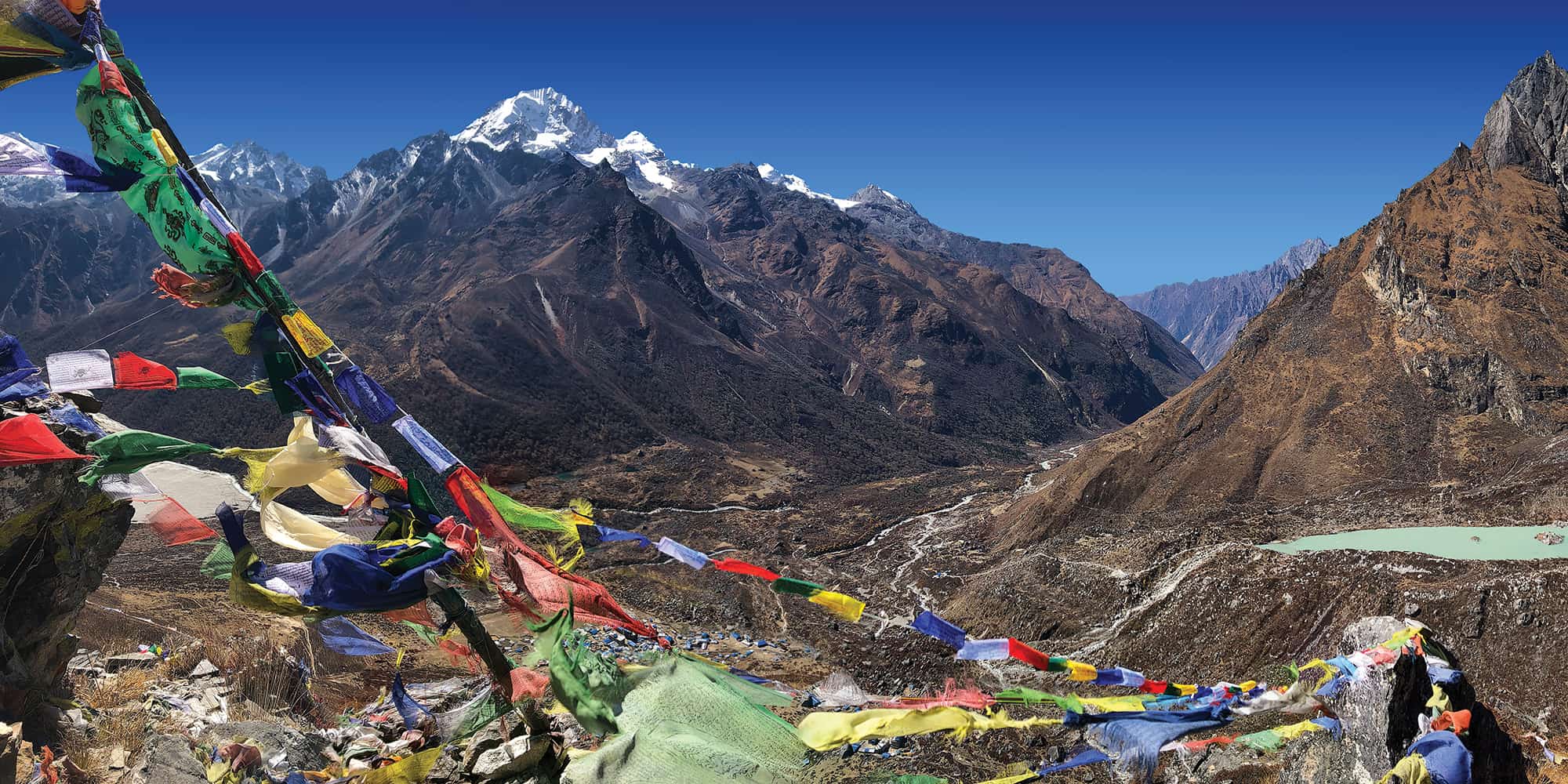
It’s easy to linger in the Langtang Valley Trek. Enjoy some stunning views of glaciers and mountains, amazingly photogenic sunsets, sacred lakes, Buddhist monasteries, Tibetan culture, and the possibility of seeing rare wildlife. In short, the Langtang Valley is a culturally rich and beautifully diverse National Park!
Key points:
- Trekking Grade: Grade 3 Moderate
- Duration & distance: About 9 days total
- Gradient: Short steep sections
- Quality of path: Formed & rough tracks, some obstacles
- Quality of markings: Signs at beginning, end and major intersections
- Experience required: No walking experience required
- Walking times: Less than 6 hours a day
- Steps: Occasional steps
- Highest point: 4984m
- Best season: Sep through to May
- Accommodation: Camping and teahouses
- Recommended map: NP105 GHT Series Langtang and Helambu, Himalayan Map House, 2017
- Recommended Guide Book: Nepal Trekking and the Great Himalaya Trail, Trailblazer, 2020.

GRADE 3


When to Trek to Langtang Valley?
When you are sitting in the congested and noisy tumult of Kathmandu, it is amazing to think that in a day’s bus drive you could be on the edge of pristine wilderness. Viewpoints above and beyond Kyangjin Gompa offer some stunning mountain vistas, and the opportunity to really immerse yourself in the Himalaya. Three high passes link to trails through Helambu and can be used to provide a range of loop itineraries.
The Langtang Valley can be trekked year-round, and although the mountains are covered in cloud during monsoon, carpets of wildflowers compensate handsomely. The most popular seasons are early October through to mid-February, when the weather is clear and stable. Then from mid-March to the end of May when the rhododendron forests are in full bloom. Care should be taken when attempting any of the high passes; Kangja (Ganja) La, Tilman Pass and Tilman East Pass. All are susceptible to sudden, fierce storms and snowfall at any time of year.

Langtang Valley Accommodation and Permits
Comfy teahouses are in every village from Dhunche and Syabrubesi to Kyangjin Gompa. After which you will need camping equipment. Supplies are expensive in Kyangjin so try to carry in as much as possible. If you want to attempt the high passes you will need ropes and rock, ice and snow climbing equipment.
Established in 1976, Langtang National Park has a reputation for being well managed. Locals actively help to maintain Park biodiversity and ecology. Human impact is limited but not absent as grazing is allowed in high pastures and permanent communities are permitted to exist in the heart of the Park.
As at August 2019, Rasuwa District (Tamang Heritage Trail) has a trekking permit of US$10 per person per week. Plus the Langtang National Park entry fee of NRs 3000 per person (foreigners), NRs 1500 (SAARC nationals) and NRs 100 (Nepali nationals).
Other Trails in Langtang Valley and Helambu
The Helambu and Langtang Valley region offers GHT through-hikers a wide range of options from technical routes to easy trails suitable for winter hiking and mountain biking.
An enjoyable village-to-village trek that is ideal in the winter-season. For those preferring a lower-altitude route links The Last Resort to Betrawati via Ratnaule, Pokhari Bhanjyang, Golphu, Kharnaitar and then to Betrawati (total 6-8 days, local teahouses en route). At any point along this route you can branch north towards Langtang by crossing one of the Tilman passes, Kangja (Ganja) La or Gosainkund. A road links Betrawati with Syabrubesi as well as a number of trails that head into the Ganesh Himal.
Shivapuri
The highest point on the northern Kathmandu valley rim, offers a stunning viewpoint (2732m, 6hrs) of the city below. Try to go on an clear night when the lights imitate the stars above. There are many trails, which often causes confusion, so take a guide who knows the way.
Panch Pokhari
Panch Pokhari, translates as ‘five lakes’, is a very popular pilgrimage site in the monsoon and location of a Mahadev Temple. These five sacred lakes at 4010m make an excellent 9-day loop trek from the road-head town of Chautara. The route is via Sano Okhareni, Kami Kharka, Pauwa Bas, Hille Bhanjyang, Nasim Pati and then to Panch Pokhari. Instead of returning the same route, head down to Tupi Danda and then via Dhap to the road-head at Melamchi. And maybe take an extra day or two to relax en route? Chautara, where you begin the trek with a long ridge climb, is a few hours’ drive from the centre of Kathmandu. The trail ascends the Kamikharka Danda above the Indrawati Khola before linking with the Hutprang Danda and then heading north to the lakes.
The villages en route are a diverse blend of Hindu, Tamang and Bhotia communities separated by extensive rhododendron, pine and fir forests. From the lakes there are great views of the Kangja Himal, Jugal Himal, Rolwaling Himal and distant views of Mt Everest, Mt Makalu and Kanchenjunga. This route can be combined with treks to/from Helambu, Gosainkund and over Kangja (Ganja) La or one of the Tilman passes to the Langtang valley. Alternatively, you could combine with the other sacred lakes in the region at Gosainkund or Bhairav Kund for a doubly auspicious trek!
Kangja (Ganja) La
This pass should only be attempted by experienced trekking groups with appropriate climbing and camping equipment. Kangja La offers a great circular trek back through Helambu, some fantastic views of the Langtang range and an approach to the popular trekking peak, Naya Kanga. From Kyangjin Gompa, retrace the trail towards Langtang village and after about 20 minutes take the left fork, which drops down to the river and a small wooden bridge. A small but obvious trail climbs through birch and rhododendron forest to simple teahouses and a good campsite, Ngegang Kharka (4430m, 2hrs). Continue climbing, staying on the west bank of a watercourse, across steep ground until you reach the base of moraine deposited by the glacier above, and a potential campsite (4640m, 2hrs).
The pass is a further 2-hour climb up a steep rock scramble, which is often made treacherous by snow. Mountaineering skills and a fixed rope may be necessary to reach Kangja La (5130m) and to descend. There is a steep descent on loose moraine for 3 hours, do not head towards the glacier rather, stay on the east-facing (right) slope of the valley. Continue descending past some kharka and staying high on, but not on top of, a ridge that runs almost due south above the Yangri Khola. There is a good campsite at Keldang (4420m) after another 2 hours with water from a tributary of the Yangri Khola. Continue to traverse the ridge without losing height. The next campsite is Dhukpa (4030m, 6hrs). Follow the ridge until the trail swings up to some prayer flags (1hr) and then descends steeply to Tarkeghyang and the main Helambu trails.
The main route continues to Melamchi Bazaar (870m, 2 days via Sermathang) or via Tharepati and Chisapani (see reverse of Kathmandu to Gosainkund, days 1-4).
How Much does the Langtang Valley Trek Cost?
To help you budget and plan, we’ve made a comprehensive costing explanation on How Much Does the GHT Cost? But here’s a simplified breakdown.
GHT Langtang Valley Trek for 10-days estimated costs:
- Solo as much as possible US$930.
- Twin-share with minimum guiding US$935 per person.
- Twin-share fully supported US$2,360 per person.
Do you have any questions about costs? Please Get in Touch for more details.
Customisation is Normal
Want to do things a little differently? Maybe take some extra time, or go a bit faster? Or avoid technical sections or combine with other trails? Every GHT trek is different and that changes the price, but please feel free to Get in Touch to ask questions and how to customise your own trek.
Bookings
Please note that www.greathimalayatrail.com does not handle bookings for treks. We are here to inform you about the trails and logistics, but you will need to book through a registered trekking operator in Nepal. If you would like an operator recommendation or feedback on a company you are already talking to, then please Get in Touch.
Your Impacts on the Langtang Valley Trek

Solo (Independent)
Langtang Valley is a low impact trek for the solo hiker with moderate social impacts and relatively low GHG and waste impacts.
Consider taking a little extra time to explore side trips or stay a little longer to improve your social impact.


Twin Share (Independent)
Langtang Valley is a low impact trek for small groups with moderate social impacts and relatively low GHG and waste impacts.
Consider taking a little extra time to explore side trips or stay a little longer to improve your social impact.


Camping (supported)
A high social impact is from having a camping crew who will buy local products and services, but it increases your footprint.
Despite the good social impact, it is hard to justify camping on this trek.

For more information about social, Green House Gas and waste impacts of treks, see The Impact of your Trek.
- Destination
- DepartureKathmandu
- Dress CodeMid-altitude alpine clothing and camping equipment required
- IncludedLangtang Valley
- GradeGrade 3
- Idea Date Range15/10/2021
- Style of TrekTeahouse or camping
FROM OUR GALLERY
Stunning views of glaciers and mountains, amazingly photogenic sunsets, sacred lakes, Buddhist monasteries, Tibetan culture, and the possibility of seeing rare wildlife – Langtang is a culturally rich and beautifully diverse national park.


Day 1: Dhunche–Thulo Syabru–Lantang Khola trail 8-10hrs drive + 6hrs
Day 2: Syabru Besi – Rimche 5.5hrs
Day 3: Rimche–Ghoratabela 4¾hrs
Day 4: Ghoratabela–Kyangjin Gompa 4¾hrs
Day 5: Kyangjin Gompa all day
Days 6-9: Kyangjin Gompa–SyabruBesi–Kathmandu


